
SECURELY BECOME A 2025
WEATHER NUT SUPPORTER TODAY
–> When 4% of readers support at any level,
this community weather resource remains active:
(Secure options include Cards, PayPal, Venmo, Check)
~~~~~~~~~~~~~~~~~~
TABLE OF CONTENTS
* Daily Celestials (Sun/Moon Data)
* Sponsor Note
* Morning Discussion
* TIP: Scroll below for sections, or read all
~~~~~~~~~~~~~~~~~~~~~~
YOUR DAILY CELESTIALS
~~~~~~~~~~~~~~~~~~~~~~
STAR:
–OUR STAR ROSE AT: 6:48am this morning
–OUR STAR SETS AT: 5:20pm this evening
–TOTAL DAYLIGHT TIME: 10 hours and 32 minutes
MOON:
–OUR MOON RISES AT: 6:37pm this afternoon
–MOON RISE DIRECTION: East-Northeast
–OUR MOON SETS AT: 7:48am tomorrow morning
–MOON SET DIRECTION: West
–MOON PHASE: Waning Gibbous (99.2%)
~~~~~~~~~~~~~~~~~~~~~~
A NOTE FROM OUR SPONSOR
~~~~~~~~~~~~~~~~~~~~~~
Dave Hayes The Weather Nut is Sponsored by Individual Community Members, Patrons, and Tandem Bagel Company… No matter the weather, Tandem Bagel is always there for you at several valley locations to make your mornings brighter! With *New Pizza Bagels(!)*, along with bagels baked fresh daily (including Gluten-Free options), house-whipped cream cheese, coffee, and tons of lunch options, Tandem is the perfect quick stop for lunch, breakfast, or a coffee and bagel to go.
You can either 1) visit them in Easthampton, Northampton, Hadley, Florence, and/or West Springfield, 2) hire them to cater your next event, or 3) use their super-streamlined online ordering tool by visiting their website and clicking the “Catering” or “Order Online” links at https://www.tandembagelco.com
~~~~~~~~~~~~~~~~~~~~~~
YOUR MORNING DISCUSSION
~~~~~~~~~~~~~~~~~~~~~~
Good morning folks, except for perhaps some spots in far northern MA or SVT/SWNH, snow has changed (or is changing to) to sleet and freezing rain or freezing drizzle, with some plain rain in the far southern valley, and especially down into north-central CT.
Showers of freezing rain in southern areas and sleet in northern areas will continue to develop at times this morning with up to a tenth of an inch or so of ice accretion in some areas, causing slippery travel on untreated surfaces and roads as our storm continues to track into Quebec Province, well to our northwest, with colder air locked in at the surface.
Areas like the Berkshires, western hilltowns, Franklin County, northern CMass on north into VT and NH will see greater impacts from icing vs. areas like central Hampden County south into northern CT in the lower valleys where we should turn to plain rain faster, if we haven’t already.
Our storm will lift northeast and a dry slot will work through our region by late morning to early afternoon, followed by high temps into the mid 30s to low 40s as breezy conditions develop out of the southwest (which will later veer around from the west and pick up speed as we move into tonight).
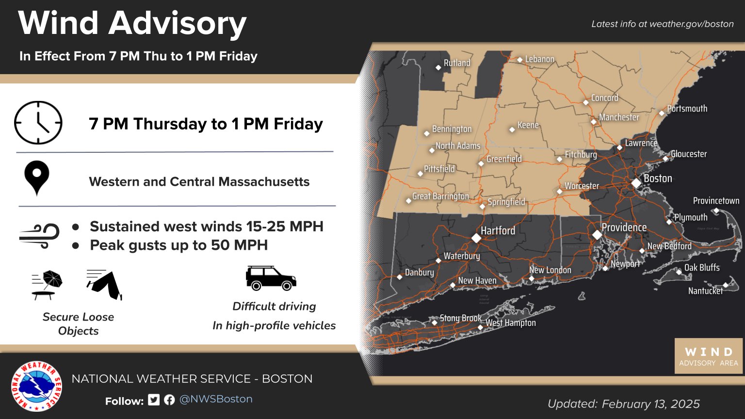
Wind Advisories have been hoisted for WMass, CMass, SVT and SWNH, and gusts will blow from the west 30-50mph this evening and overnight, so a noisy night lies ahead for some with lows dropping into the mid teens to mid 20s.
For Friday, gusty conditions will be present in the morning with wind gusts up to 35mph, slackening as the day wears on due high pressure moving in and relaxing the pressure gradient later in the day.
Said high pressure will provide us with a lovely and sunny day with highs in the mid 20s to low 30s, followed by lows in the upper single digits to mid teens with clouds increasing.
——————-
SECURELY BECOME A 2025 SUPPORTER TODAY
Your support is what fuels these reports
(Secure options include Cards, PayPal, Venmo, Check)
——————-
For Saturday, we’re getting ready for our next winter storm in this active period. Clouds will thicken and skies will become overcast as highs reach the upper 20s to low 30s.
With temps plenty cold at all levels of the atmosphere, snow will move in, likely between 3-6pm at this point, and it will begin accumulating soon after its arrival.
At this stage, we could see a low-moderate level snowfall, something on the order of 2-5” of snow (maybe a little more?) before milder air aloft works into the region and turns us over to sleet by Sunday morning.
Uncertainty remains, however, as this storm has been trending a bit more southerly, which could prolong snow and/or shorten icing time on Sunday, possibly ending as snow as the storm sweeps northeast and away from us by Sunday night.
If the storm ends up tracking more west, then some of us may turn to plain rain on Sunday, so I will keep updating as we get closer.
The bottom line for now, is that wintry impacts await us for late Saturday afternoon through Sunday, so plan accordingly.
Lows Saturday night will drop into the low to mid 20s, and highs on Sunday will reach the 30s, with lows bottoming out into the mid teens to low 20s with black ice potentially forming due to sub-freezing temps impacting any standing water.
As this storm sweeps by Sunday night, an Arctic blast of cold air will be unleashed into the region behind it with strong wind gusts expected. In fact, upwards of 50mph gusts are expected for Monday, which could help generate wind chills that may reach down to near 0º Monday night!
In general, the Monday through Wednesday timeframe looks to feature partly to mostly sunny skies with highs in the teens and 20s and lows in the single digits, starting off quite windy and then slackening as high pressure moves in towards mid-week.
By Thursday, however, the potential is there for a coastal winter storm, so our busy winter pattern continues well into next week!
Have a great day, and if you’d like to keep me in your service, you can chip in any comfortable one-time or monthy amount at the secure link to my site below, thank you!
——————-
SECURELY BECOME A 2025
WEATHER NUT SUPPORTER TODAY
–> When 4% of readers support at any level,
this community weather resource remains active:
(Secure options include Cards, PayPal, Venmo, Check)
“Follow your bliss and the universe will open doors for you where there were only walls.”
― Joseph Campbell