
SECURELY BECOME A 2025
WEATHER NUT SUPPORTER TODAY
–> When 4% of readers support at any level,
this community weather resource remains active:
(Secure options include Cards, PayPal, Venmo, Check)
~~~~~~~~~~~~~~~~~~
TABLE OF CONTENTS
* Daily Celestials (Sun/Moon Data)
* Sponsor Note
* Morning Discussion
* TIP: Scroll below for sections, or read all
~~~~~~~~~~~~~~~~~~~~~~
YOUR DAILY CELESTIALS
~~~~~~~~~~~~~~~~~~~~~~
STAR:
–OUR STAR ROSE AT: 6:51am this morning
–OUR STAR SETS AT: 5:18pm this evening
–TOTAL DAYLIGHT TIME: 10 hours and 27 minutes
MOON:
–OUR MOON RISES AT: 4:22pm this afternoon
–MOON RISE DIRECTION: East-Northeast
–OUR MOON SETS AT: 7:06am tomorrow morning
–MOON SET DIRECTION: West-Northwest
–MOON PHASE: Full Snow Moon (98.7%)
~~~~~~~~~~~~~~~~~~~~~~
A NOTE FROM OUR SPONSOR
~~~~~~~~~~~~~~~~~~~~~~
Dave Hayes The Weather Nut is Sponsored by Individual Community Members, Patrons, and Tandem Bagel Company… No matter the weather, Tandem Bagel is always there for you at several valley locations to make your mornings brighter! With *New Pizza Bagels(!)*, along with bagels baked fresh daily (including Gluten-Free options), house-whipped cream cheese, coffee, and tons of lunch options, Tandem is the perfect quick stop for lunch, breakfast, or a coffee and bagel to go.
You can either 1) visit them in Easthampton, Northampton, Hadley, Florence, and/or West Springfield, 2) hire them to cater your next event, or 3) use their super-streamlined online ordering tool by visiting their website and clicking the “Catering” or “Order Online” links.
~~~~~~~~~~~~~~~~~~~~~~
YOUR MORNING DISCUSSION
~~~~~~~~~~~~~~~~~~~~~~
Good morning everybody, it is not warm out! Temps have dropped into the single digits and teens for low temps under clear skies (for now). Look at us, plunging into another wintry day, good job everybody! #TomPapaReference
For today, we’ll see high and mid-level clouds increase from our south, as a snowstorm slides eastward off of the Mid-Atlantic coastline. Highs will reach the upper 20s to low 30s with a mix of sun and clouds. Southwest wind gusts may pick up and gust over 20mph at times as the Mid-Atlantic low approaches.
Clouds continue to increase tonight, especially south of the Route 2 corridor, and I can’t rule out some snow showers reaching into southern parts of northern CT, with maybe a thin sugar coating of snow in a few spots.
Otherwise, accumulating snow stays south of the greater WMass region, with lows bottoming out into the upper single digits and teens.
Highs on Wednesday will reach similar levels to today (upper 20s to low 30s) with partly sunny skies early followed by increasing clouds once again as a storm starts to sweep northeast up the Appalachians late in the day.
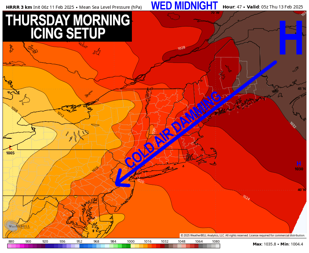
As the storm approaches from our southwest, it will spread snow into the greater WMass region tomorrow night, starting between 7-10pm from southwest to northeast.
This is not a strong storm system, but it will likely bring about 1-4” of snow, changing to sleet during the pre-dawn hours of Thursday morning with lows dropping into the low to mid 20s.
——————-
SECURELY BECOME A 2025
WEATHER NUT SUPPORTER TODAY
–> When 4% of readers support at any level,
this community weather resource remains active:
(Secure options include Cards, PayPal, Venmo, Check)
——————-
While a secondary low may try to form and pass southeast of us early Thursday morning, it will probably be too little too late to prevent a changeover to ice and then even rain briefly everywhere later Thursday morning before everything lifts northeast and away by afternoon.
Having said that, I can’t rule out some parts of northern MA into SVT and SWNH remaining as freezing rain or freezing drizzle with more of an icing concern up that way.
The bottom line is that the early Thursday morning commute looks icy and slippery, so give yourself extra time if you have to hit the road.
Highs on Thursday will reach well into the 30s, followed by lows in the mid teens to low 20s as we clear out.
Friday looks like a gorgeously sunny day with highs in the 25-30º range with light wind and lows in the low teens.
Saturday will start off dry, but clouds will increase as highs climb into the low to mid 30s.
By sometime in the afternoon, another storm system will be approaching, likely with snow moving into the region, but details are quite uncertain as to how this next storm system unfolds into Saturday night and the rest of the weekend.
It certainly looks like we would change to an icy mix, but I’ll need more time as we get closer to parse everything out.
Then we move into a fair weather period early to middle of next week before another larger winter storm system looks possible for next Thursday as our busy winter pattern continues!
Have a great day!
——————-
SECURELY BECOME A 2025
WEATHER NUT SUPPORTER TODAY
–> When 4% of readers support at any level,
this community weather resource remains active:
(Secure options include Cards, PayPal, Venmo, Check)
“Follow your bliss and the universe will open doors for you where there were only walls.”
― Joseph Campbell