
SECURELY BECOME A 2025
WEATHER NUT SUPPORTER TODAY
–> When 4% of readers support at any level,
this community weather resource remains active:
(Secure options include Cards, PayPal, Venmo, Check)
~~~~~~~~~~~~~~~~~~
TABLE OF CONTENTS
* Daily Celestials (Sun/Moon Data)
* Sponsor Note
* Morning Discussion
* TIP: Scroll below for sections, or read all
~~~~~~~~~~~~~~~~~~~~~~
YOUR DAILY CELESTIALS
~~~~~~~~~~~~~~~~~~~~~~
STAR:
–OUR STAR ROSE AT: 6:52am this morning
–OUR STAR SETS AT: 5:17pm this evening
–TOTAL DAYLIGHT TIME: 10 hours and 25 minutes
MOON:
–OUR MOON RISES AT: 3:11pm this afternoon
–MOON RISE DIRECTION: East-Northeast
–OUR MOON SETS AT: 6:40am tomorrow morning
–MOON SET DIRECTION: West-Northwest
–MOON PHASE: Waxing Gibbous (95.3%)
~~~~~~~~~~~~~~~~~~~~~~
A NOTE FROM OUR SPONSOR
~~~~~~~~~~~~~~~~~~~~~~
Dave Hayes The Weather Nut is Sponsored by Individual Community Members, Patrons, and Tandem Bagel Company… No matter the weather, Tandem Bagel is always there for you at several valley locations to make your mornings brighter! With *New Pizza Bagels(!)*, along with bagels baked fresh daily (including Gluten-Free options), house-whipped cream cheese, coffee, and tons of lunch options, Tandem is the perfect quick stop for lunch, breakfast, or a coffee and bagel to go.
You can either 1) visit them in Easthampton, Northampton, Hadley, Florence, and/or West Springfield, 2) hire them to cater your next event, or 3) use their super-streamlined online ordering tool by visiting their website and clicking the “Catering” or “Order Online” links.
~~~~~~~~~~~~~~~~~~~~~~
YOUR MORNING DISCUSSION
~~~~~~~~~~~~~~~~~~~~~~
Good morning folks, got any sunrise pics? Or sunset pics from last night? We’ve enjoyed a lovely and rather celestial pair of bookends to the night that just passed us by, so I’d love to see any pics you took.
As for our weather, we’re into a 3-day period of relaxed conditions, as another zonal slider storm passes well south of us for Tuesday and Tuesday night, bringing snow to the Mid-Atlantic this time.
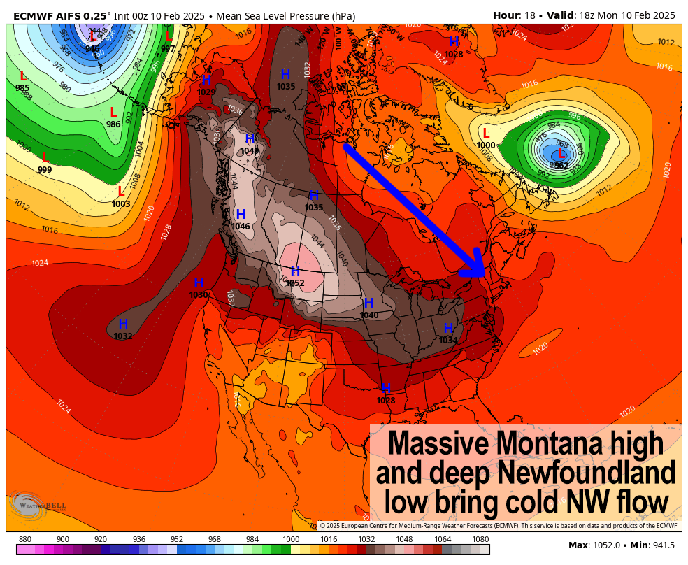
The quieter weather is due to a massive high pressure that is stretched out from southern Alberta, Canada all the way southeast into the center of the country. Between that and super potent low at the eastern tip of Newfoundland, Canada, we are in a lighter but persistent northwest flow of air which will keep us in the mid 20s to low 30s under partly sunny to mostly cloudy skies at times today, along with a few snow showers in the Berkshires and SVT. Lows will dip to the single digits, so a very cold night lies ahead.
Given these highs near or just above freezing, our current snowpack, the higher sun angle, and very cold temps at night, there is going to be melting and refreezing occurring each day/night, with black ice formation so just be aware.
For Tuesday, we’ll see more dry conditions, but clouds will increase as the day wears on, due to a weak storm passing south of us and bringing snow to the Mid-Atlantic and perhaps spreading some snow showers into far southern CT/RI and southeast MA. Highs will reach the upper 20s to low 30s with lows in the single digits once again.
Wednesday should start off partly sunny with similar highs to Tuesday, but clouds will increase late as another stronger storm is set to track northeast to our region.
There is uncertainty with this system in that at first glance a primary low will try to run west of us, which would usually just mean a snow to rain set up.
——————-
SECURELY BECOME A 2025
WEATHER NUT SUPPORTER TODAY
–> When 4% of readers support at any level,
this community weather resource remains active:
(Secure options include Cards, PayPal, Venmo, Check)
——————-
However, we’ll have plenty of cold air in place ahead of the storm, and there are signals for a secondary low to form and for that to pass southeast of us, which could lock in surface cold air, producing a couple-three inches of snow on the front end with a period of icing developing for Thursday morning causing problems for travel and notably the morning commute.
This bears watching and I will keep you updated as we get closer. Highs Thursday will reach into the 30s potentially, with lows in the teens as we dry out.
Friday represents a lovely end to the week with high pressure moving through with highs in the 25-30º range under mostly sunny skies, and lows in the teens.
By the weekend, we have more winter storminess expected, but there’s lots to sort out still. We actually see back to back storm systems, with the first one starting as early as Saturday afternoon, but likely more towards the nighttime.
A second wave may then pass through later Sunday, and both systems could bring a mix of snow and ice, and depending on track, rain for some.
The bottom line is we have an active pattern continuing, but we’ll get a few days here to reset the table, and take a breather for a bit… or maybe that’s me talking to myself out loud in front of you? ;-)
Have a great day!
——————-
SECURELY BECOME A 2025
WEATHER NUT SUPPORTER TODAY
–> When 4% of readers support at any level,
this community weather resource remains active:
(Secure options include Cards, PayPal, Venmo, Check)
“Follow your bliss and the universe will open doors for you where there were only walls.”
― Joseph Campbell