NWS Boston high temps
TABLE OF CONTENTS
* Daily Celestials (Sun/Moon Data)
* Weekly Weather Nutshell
* Morning Discussion
* TIP: Scroll below for sections, or read all
~~~~~~~~~~~~~~~~~~~~~~
YOUR DAILY CELESTIALS
~~~~~~~~~~~~~~~~~~~~~~
STAR:
–OUR STAR WILL RISE AT: 6:53am this morning
–OUR STAR WILL SET AT: 5:16pm this evening
–TOTAL DAYLIGHT TIME: 10 hours and 23 minutes
MOON:
–OUR MOON WILL SET AT: 6:17pm this evening
–MOON SET DIRECTION: West-Southwest
–OUR MOON WILL RISE AT: 8:06am tomorrow morning
–MOON RISE DIRECTION: East-Southeast
–MOON PHASE: Waxing Crescent (0.6%)
~~~~~~~~~~~~~~~~~~~~~~
>>> A NOTE FROM OUR SPONSOR <<<
Dave Hayes The Weather Nut is Sponsored by Individual Community Members, Patrons, and Gerard, Ghazey & Bates, P.C. GGBPC is a Northampton-based law firm regarded as the voice of pragmatic and well-reasoned estate planning, elder law and tax guidance in Western Massachusetts. The firm specializes in estate planning law, and expertly handles other matters such as Elder Law, Tax Law, as well as Real Estate purchase, sales, and refinance transactions. Contact GGBPC today to see how they can help!
~~~~~~~~~~~~~~~~~~~~~~
YOUR WEEKLY WEATHER NUTSHELL
~~~~~~~~~~~~~~~~~~~~~~
–Dense patchy fog, some freezing, abates, lifts, and breaks up as southwest flow develops
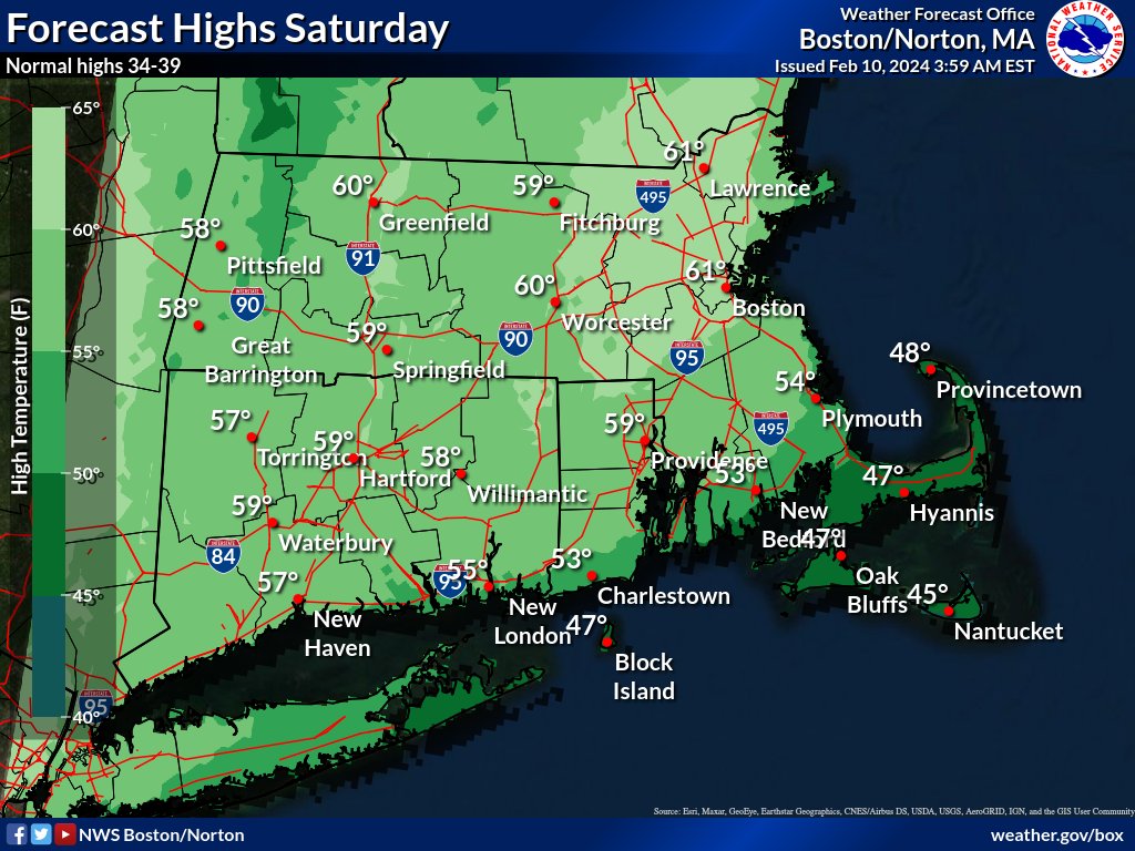
–Partly to mostly sunny skies increase as temps soar well into the 50s in the mild sector of a storm well north of us
–Some records may be broken or tied if temps rise into the upper 50s to low 60s
–A cold front and shortwave moves through late today, and brings a line of scattered showers with potential for an isolated thunderstorm with small hail
–Gusty winds may accompany this frontal passage, though the showers and any storm should weaken as they move into and east of the Pioneer Valley
–Lows tonight drop to the low to mid 30s under mostly cloudy skies
–Sunday and Monday look pleasant, and a bit more seasonable, though above average for temps, with highs upper 30s to mid 40s both days (lows in the mid 20s)
–We’ll see more clouds on Sunday with partial sunshine, and more sun on Monday ahead of the Tuesday snowstorm
–By Monday night, clouds will increase as a storm tracks from the Tennessee Valley toward the Mid-Atlantic coastline
–This will push snow into the greater WMass region around or just after midnight going into Tuesday morning, so the morning commute is likely impacted with accumulating snow
–Snow will fall, heavily at times for some, on Tuesday and taper off in the evening
–Right now this looks like a moderate-sized snowstorm, somewhere between 4-10″ for much of the area, but that is an early estimate and I will refine as we get closer
–Behind the storm a northwest colder flow will develop out of Canada, and it could be blustery at times with fair weather and highs in the 30s and lows in the teens as winter reasserts itself after today’s mild spike
~~~~~~~~~~~~~~~~~~~~~~
YOUR MORNING DISCUSSION
~~~~~~~~~~~~~~~~~~~~~~
Good morning everybody, we’ve got quite the mild day ahead after fog burns off, which it’s already in the process of completing.
Southwest wind will develop pushing highs into the mid to upper 50s, and with partial sunshine developing (to full sun, in some places) I would advise getting outside and enjoying the day because winter weather is returning with colder temps, accumulating snow and blustery wind chills.
We spike temps today, theen a cold front pushes into the region with showers and a possible thunderstorm. Small hail can’t be ruled out, either, with best chance of any thunder or hail occuring over the Taconics, Berkshires, western hilltowns, and SVT before waning into the valley and points east.
The timeframe for showers is 4pm-7pm from west to east, and some gusty winds may kick up with these as well, as lows drop to the low to mid 30s.
Sunday and Monday feature brief high pressure with cooler highs in the upper 30s to mid 40s both days. Sunday looks like a more partly sunny day with remnant moisture around, but a more fully sunny day looks good for Monday. Lows will be in the 20s with dry conditions.
However, I’ll be watching clouds increase Monday night as a southern stream storm system tracks east-northeast out of the Tennessee Valley and interacts with an upper trough that will be swinging into the Ohio valley and Great Lakes.
This storm will exit the coastline and head for an area south of Nantucket.
With a night time onset after midnight going into early Tuesday morning, and a southerly storm track and cold air to our north, this should be enough to produce accumulating snow in our WMass region overnight, and through Tuesday which likely will impact the Tuesday morning commute.
There is still some uncertainty about the storm track, whether or not a secondary storm develops and what that does to the precipitation shield, and a few other factors, but right now it looks like a moderate snowstorm with a 4-10″ snowfall across the region looks pretty likely, with potential for lower snow range north of the Rt. 2 corridor, and higher end south of the Rt. 2 corridor.
Any snow will taper off Tuesday evening.
For the mid to late week period, that storm looks to be swung north and even northwest over eastern Quebec, which could help drive cold air and windy conditions out of the northwest into our region with highs in the 30s and lows in the teens with cold wind chills developing along with fair weather.
Winter weather is returning, so enjoy today’s Spring taste, and have a great day!
>>> BE KIND <<<
“Hello babies. Welcome to Earth. It’s hot in the summer and cold in the winter. It’s round and wet and crowded. On the outside, babies, you’ve got a hundred years here. There’s only one rule that I know of, babies: Goddamn it, you’ve got to be kind.”
–Kurt Vonnegut
