
Windy today
–Weekly Nutshell (Quick impact list)
–Sponsor Note (Tandem Bagel Co.)
–NWS Alerts (Advisories, Warnings, Watches)
–Celestial Data (Sun/Moon info)
–Regional Summaries (quick in and out details)
–Morning Discussion (Longer-form explanation)
~~~~~~~~~~~~~~~~~~~~~~
DAVE’S WEEKLY WEATHER NUTSHELL
–Patchy dense fog this morning, some of it freezing fog with slippery surfaces
–Some areas in the low 50s already, some in the upper 20s!
–Temps rise into the 40s and 50s today, some spots south/east of Springfield may hit 60º!
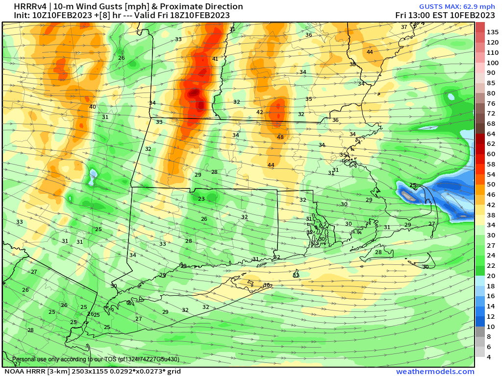
–Windy, westerly gusts 30-50mph, mostly sunny
–Cold front tonight, a few flurries, colder, lows 20s
–Breezy Saturday, cold, with sunshine and highs in the 30s, lows teens
–Sunday milder, highs 40s, mostly sunny, clouds at night, lows near freezing
–Storm stays south but mostly cloudy on Monday
–Variable clouds through mid week, highs upper 30s to 40s, but late week temps could reach record levels well into the 50s
–A substantial storm system with powerful cold front arrives late week, likely with rain, but then colder air for next weekend, but before we jump into the weather discussion/details below, let’s check a note from our local and delicious sponsor, #TandemBagelCo, with their newest location in West Springfield, MA.
~~~~~~~~~~~~~~~~~~~~~~
A NOTE FROM OUR SPONSOR:
Dave Hayes The Weather Nut is Sponsored by Members, Patrons & Tandem Bagel Company… No matter the weather, Tandem Bagel is always there for you at several valley locations to make your mornings brighter! With bagels baked fresh daily (including Gluten-Free options), house-whipped cream cheese, coffee, and tons of lunch options, Tandem is the perfect quick stop for lunch, breakfast, or a coffee and bagel to go. Find them in Easthampton, Northampton, Hadley, Florence, and West Springfield, or use their super-streamlined online ordering tool by visiting their website.
~~~~~~~~~~~~~~~~~~~~~~~~~~~~~~~~
***DHTWN DAILY WEATHER REPORT***
~~~~~~~~~~~~~~~~~~~~~~~~~~~~~~~~
NATIONAL WEATHER SERVICE ALERTS
–Wind Advisories are up for the Berkshires, western hilltowns and southern VT for gusts up to 50mph possible today
DHTWN REMINDER
–The odds of being a human are 1 in 400,000 billion, so do or share something you love today, even in a small way (see Kurt Vonnegut quote at end of post)
DAILY CELESTIAL (STAR):
–OUR STAR ROSE AT: 6:53am this morning
–OUR STAR WILL SET AT: 5:16pm this evening
–TOTAL DAYLIGHT TIME: 10 hours and 23 minutes
NIGHTLY CELESTIAL (MOON):
–OUR MOON WILL RISE AT: 10:17pm tonight
–OUR MOON WILL SET AT: 9:32am tomorrow morning
–MOON RISE DIRECTION: East
–MOON SET DIRECTION: West-Southwest
–MOON PHASE: Waxing Gibbous (80.5%)
~~~~~~~~~~~~~~~~~~~~~~~~~~~~~~~~
DAILY TERRESTRIAL (ZoneCast)
ZONE 1 (Northern Region)
Southern VT, Southwest NH, N. Taconics NY
–High Temps: Mid to Upper 40s
–Low Temps: Low to Mid 20s
–Wind: Westerly winds gust 30-50mph today
–Skies: Partly sunny west, mostly sunny east of the Greens
–Precipitation: A few morning showers possible, freezing fog very early in patchers, and a few flurries or snow showers tonight, but mostly dry during today and tonight
ZONE 2 (Central Region)
WMass, N. CMass, N. Litchfield County, C./S. Taconics NY
–High Temps: Upper 40s to Mid 50s
–Low Temps: Mid to Upper 20s
–Wind: Westerly winds gust 30-50mph today, highest in the hills
–Skies: Mostly sunny
–Precipitation: Patchy dense fog this morning burns off, a few flurries possible tonight, otherwise dry
ZONE 3 (Southern Region)
S. CMass, S. Litchfield County, NC.CT, & NE.CT
–High Temps: Mid to Upper 50s, a few spots may hit 60º
–Low Temps: Uppret 20s
–Wind: Westerly winds gust 25-45mph today
–Skies: Mostly sunny
–Precipitation: Patchy dense fog this morning, with a few flurries tonight possible
~~~~~~~~~~~~~~~~~~~~~~~~~~~~~~~~
MORNING DISCUSSION
Good morning everybody, we have a snaky warm front slithering around the region this morning, with some areas in the low 50s and others in the upper 20s to low 30s.
Combining this with patchy dense fog, and black ice is possible, so watch your surfaces as you head out the door.
Fog will lift by mid-morning or so and the warm front will track fully through the region as a storm system currently over southwest Quebec keeps tracking northeast into Canada.
This will help produce mostly sunny skies, develop southwest to westerly winds gusting 30-50mph at times (highest in the hills) and cause highs to rise into the 40s and 50s with some folks reaching 60º! Records highs may be broken in some spots.
A cold front sweeps through tonight, and drops our temps down into the 20s for lows as winds decrease to about 20-35mph.
Saturday will be seasonably cold with highs in the 30s under mostly sunny skies, and continued breezy conditions with northwest gusts to 30mph at times. Lows will be in the teens under clear skies and decreasing wind.
Sunday looks milder as high pressure passes into the region with highs in the 40s under mostly sunny skies. This will help suppress the coastal storm south of our region for early Monday, but clouds will build Sunday night with lows in the 20s and highs on Monday in the low to mid 40s with clouds early, but partly sunny skies developing later in the day.
At the moment, it looks like we’ve got fair weather through much of next week with highs in the upper 30s to 40s Monday through Wednesday, and then much milder for late week with highs in the 50s before yet another inside runner storm systems passes west of us by Friday bringing more rain into our region.
A strong cold front will move through and set us up for colder conditions next weekend, but still no wintry pattern or snowstorms in sight for now.
Have a great day!
Let’s Stay Together (click for options).
Join my Free Weekly Nutletter (click to join).
Follow me on Twitter (click to follow).
AND REMEMBER…
“Hello babies. Welcome to Earth. It’s hot in the summer and cold in the winter. It’s round and wet and crowded. On the outside, babies, you’ve got a hundred years here. There’s only one rule that I know of, babies: Goddamn it, you’ve got to be kind.”
–Kurt Vonnegut