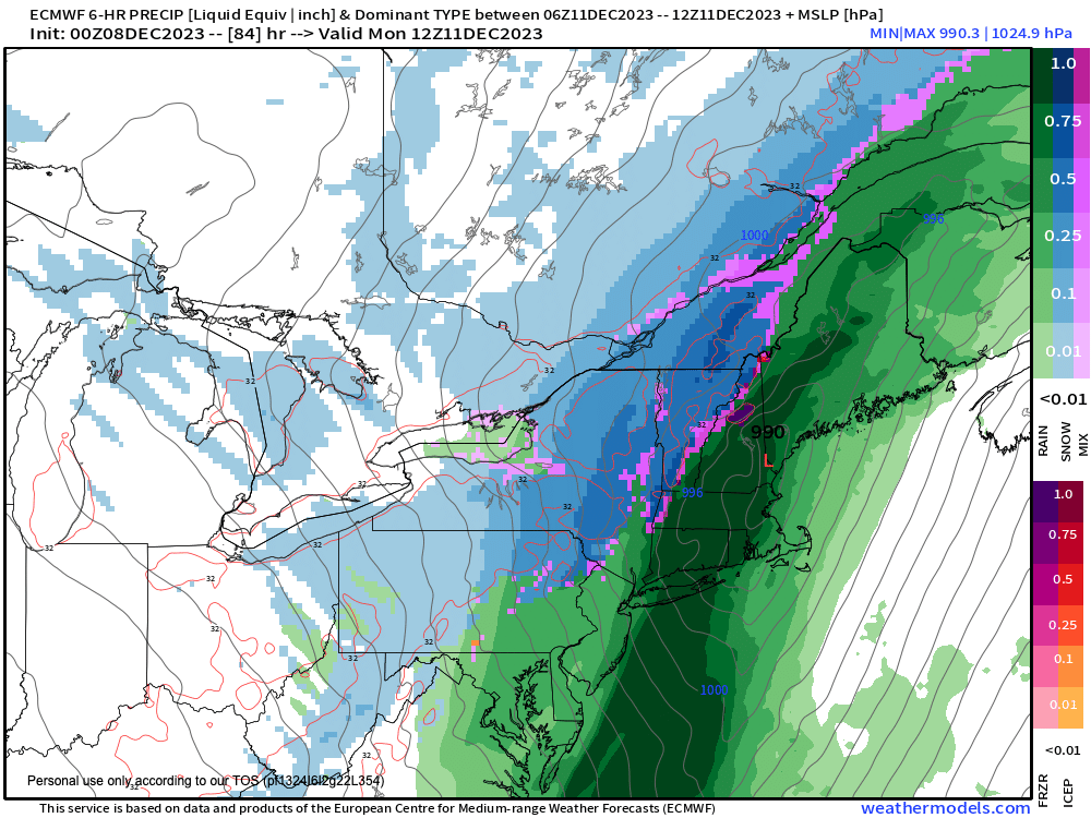
Major Windy Rainstorm with Heavy Berkshire Snow Possible Sun/Mon
TABLE OF CONTENTS
* Daily Celestials (Sun/Moon Data)
* Morning Discussion
* TIP: Scroll below for sections, or read all
~~~~~~~~~~~~~~~~~~~~~~
YOUR DAILY CELESTIALS
~~~~~~~~~~~~~~~~~~~~~~
STAR:
–OUR STAR ROSE AT: 7:05am this morning
–OUR STAR WILL SET AT: 4:18pm this evening
–TOTAL DAYLIGHT TIME: 9 hours and 13 minutes
MOON:
–OUR MOON WILL SET AT: 1:38pm this afternoon
–MOON SET DIRECTION: West-Southwest
–OUR MOON WILL RISE AT: 3:28am tomorrow morning
–MOON RISE DIRECTION: East-Southeast
–MOON PHASE: Waning Crescent (20.9%)
~~~~~~~~~~~~~~~~~~~~~~
A NOTE FROM OUR SPONSOR
~~~~~~~~~~~~~~~~~~~~~~
Dave Hayes The Weather Nut is Sponsored by Individual Community Members, Patrons, and Tandem Bagel Company… No matter the weather, Tandem Bagel is always there for you at several valley locations to make your mornings brighter! With bagels baked fresh daily (including Gluten-Free options), house-whipped cream cheese, coffee, and tons of lunch options, Tandem is the perfect quick stop for lunch, breakfast, or a coffee and bagel to go. Find them in Easthampton, Northampton, Hadley, Florence, and West Springfield, or use their super-streamlined online ordering tool by visiting their website.
~~~~~~~~~~~~~~~~~~~~~~
YOUR MORNING DISCUSSION
~~~~~~~~~~~~~~~~~~~~~~
Good morning everybody, so to pull up to the 1000 foot view for a second, I don’t expect anyone in the greater WMass region (WMass including the Berkshires, CMass, northern CT, southwest NH, southern VT and the Taconics of easternmost Columbia and Rensselaer Counties in NY which comprises my coverage/reporting area) to see a major snowstorm by Monday.
However, I am growing increasingly concerned that for the Berkshires, Taconics, western hilltowns and southern VT that we will see a sharp cold frontal passage that could crash temps early Monday morning and flip rain to moderate to heavy wet snow and cause slippery travel for high terrain Monday morning commutes well west of the I-91 corridor.
The trend for the secondary low developing as the primary low careens through teh Great Lakes has been more east and more strong, so while the Pioneer Valley points east remains mostly or all rainfall with some Monday afternoon cold advection snow showerse possible, some areas could see up to 2-6″ of wet snow and with westerlies gusting behind the cold frontal passage, some isolated outages are possible due both to Sunday night southerlies gusting 35-55mph, and then some isolated snow-loaded areas into Monday morning, so please stay tuned for updates.
Backing up, we’ve got a couple of tranquil days to move through before our Sunday/Monday system.
For today and tomorrow, I expect more clouds than sunshine as enough moisture is present aloft to keep the cloud production going, though we could see some sunny periods today vs. tomorrow.
High pressure is moving south of us today, and an upper ridge is pushing east into the northeast U.S. so we stay dry today and tomorrow with highs in the mid 30s to low 40s today with lows in the mid to upper 20s, and then milder highs in the mid 40s to low 50s tomorrow, which will feel pretty nice on the bones. Lows will set down into the low to mid 30s.
Clouds thicken Sunday, and then our storm starts pushing into the region from southwest to northeast.
The upper low will take on a neutral tilt as it sweeps through teh Ohio Valley, and then become a bit negatively tilted as it reaches the coast which will spawn a secondary low somewhere near NYC which will rip northeast into Maine by Monday.
The exact track, speed, development point, speed of strengthening, and how much the lower level low pressure circulations close off will help determine how fast the cold air is pulled in from west to east.
The trend is stronger, faster and more east so we’ll see how much that continues.
The bottom line is that showers arrive Sunday afternoon ito the evening and become heavy at times with strong southerlies picking up and gusting 35-55mph at times, which could cause some isolated outages. We can’t rule out a few thunderstorms after midnight, nor can we rule out some street flooding as well in some downpours. Rainfall of 1-3″ is possible. HIghs will reach the mid to upper 50s, so it will feel quite mild!
This is a multi-hazard storm system, with the potential for heavy wet snow early Monday morning in our high terrain areas from the western hilltowns in MA up into western Windham County VT on westward through southwest VT, the Berkshires, the northern Litchfields and the Taconics of eastern NY.
By Monday, cold air comes rushing back through, and some cold air advection snow showers are expected in the afternoon, with another Clipper system possible by mid-week.
My sole focus is now on the Sunday/Monday system, so please check back with me for updates, I will monitoring this constanty through the weekend, have a great day…
>>> BE KIND <<<
“Hello babies. Welcome to Earth. It’s hot in the summer and cold in the winter. It’s round and wet and crowded. On the outside, babies, you’ve got a hundred years here. There’s only one rule that I know of, babies: Goddamn it, you’ve got to be kind.”
–Kurt Vonnegut
