TABLE OF CONTENTS
* Daily Celestials (Sun/Moon Data)
* Weekly Weather Nutshell
* Morning Discussion
* TIP: Scroll below for sections, or read all
~~~~~~~~~~~~~~~~~~~~~~
YOUR DAILY CELESTIALS
~~~~~~~~~~~~~~~~~~~~~~
STAR:
–OUR STAR ROSE AT: 7:04am this morning
–OUR STAR WILL SET AT: 4:18pm this evening
–TOTAL DAYLIGHT TIME: 9 hours and 14 minutes
MOON:
–OUR MOON WILL SET AT: 1:18pm this afternoon
–MOON SET DIRECTION: West
–OUR MOON WILL RISE AT: 2:23am tomorrow morning
–MOON RISE DIRECTION: East
–MOON PHASE: Waning Crescent (29.2%)
~~~~~~~~~~~~~~~~~~~~~~
YOUR WEEKLY WEATHER NUTSHELL
~~~~~~~~~~~~~~~~~~~~~~
–A weak wave moves through today with not much more than a bunch of clouds and a passing flurry possible
–Highs upper 20s to mid 30s, cold, light west wind
–Lows either side of 20º tonight, clearing
–High pressure builds in to our south, increasing sunshine for Friday, highs mid 30s to low 40s, with lows in the upper 20s
–Saturday is even milder with highs in the mid to upper 40s under partly sunny skies, with lows in the mid 30s
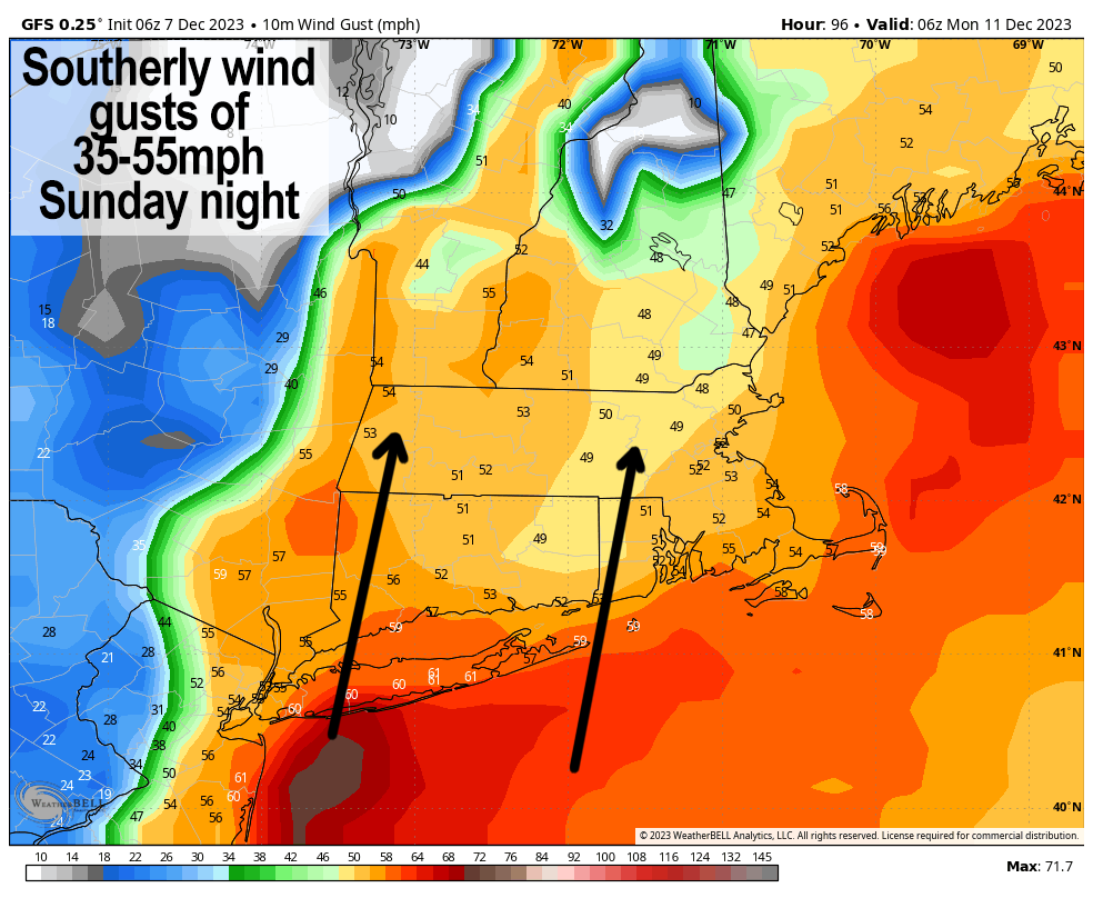
–Sunday will see increasing clouds with highs well into the 50s a as strong southerly flow is swept up the eastern seaboard
–A storm over the central Great Lakes develops a secondary low center that tracks into northern VT
–This sweeps rain and wind into our region starting sometime between later Sunday afternoon and night, and ending by around noon or so on Monday
–Strong southerly gusts of 35-55mph may produce isolated power outages, rainfall over an inch, thunderstorms possible, and back end snow in VT and the northern Berkshires could coat the ground on the way out, but before we talk zone summaries and details let’s check a note from our local and delicious sponsor, #TandemBagelCo, with their newest location in the Stop & Shop Plaza on King Street in Northampton, MA.
~~~~~~~~~~~~~~~~~~~~~~
A NOTE FROM OUR SPONSOR
~~~~~~~~~~~~~~~~~~~~~~
Dave Hayes The Weather Nut is Sponsored by Individual Community Members, Patrons, and Tandem Bagel Company… No matter the weather, Tandem Bagel is always there for you at several valley locations to make your mornings brighter! With bagels baked fresh daily (including Gluten-Free options), house-whipped cream cheese, coffee, and tons of lunch options, Tandem is the perfect quick stop for lunch, breakfast, or a coffee and bagel to go. Find them in Easthampton, Northampton, Hadley, Florence, and West Springfield, or use their super-streamlined online ordering tool by visiting their website.
~~~~~~~~~~~~~~~~~~~~~~
YOUR MORNING DISCUSSION
~~~~~~~~~~~~~~~~~~~~~~
Good morning everybody, aside from Sunday into Monday, we have mainly pedestrian, calm, peaceful weather conditions with which to interact between now and Sunday morning, and again Tuesday well into next week.
We’re quite cold today with winter time temps in the 20s and 30s for highs with partly sunny skies on average and a light west wind. Tonight will be the coldest we see for days to come, with lows in the upper teens to low 20s.
Friday looks like the nicest day over the next bunch of days, including into next week, with high pressure passing south of us and an upper level ridge moving overhead which will beget partly to mostly sunny skies and highs in the mid 30s to low 40s, with lows in the 20s.
Saturday is milder, with highs well into the 40s and dry conditions expected.
It is Sunday into Monday that is the main focus right now, and a lot of what will dictate our more precise impacts from that storm is the orientation of the upper trough axis as it sweeps into the eastern part of the country.
If it becomes negative more quickly, it could increase wind gust potential, outage potential, and heavy rain by inducing a secondary low (connected to the primary one over the central Great Lakes) that tracks more south to north.
However, it stays more neutral, then could create a more west to east component to the flow with a secondary storm tracking into central or northern New England, which would still produce plenty of wind, but possibly cut down on rainfall a bit, and also introduce potential for a changeover to heavy wet snow in the Berkshires and southern VT and the Taconics, so this all bears watching.
The second scenario is more progressive too, meaning inclement weather is active in our area for less time than the southerly freight train of rain and wind in the first scenario, which could also produce some street flooding.
Anyway, I am on it, and will keep you updated about this storm for sure.
After the storm passes, some cooler west winds gusting to 25mph picks up Monday night, and dry, calm, more seasonable conditions will arrive into the middle of next week.
Have a great day!
>>> BE KIND <<<
“Hello babies. Welcome to Earth. It’s hot in the summer and cold in the winter. It’s round and wet and crowded. On the outside, babies, you’ve got a hundred years here. There’s only one rule that I know of, babies: Goddamn it, you’ve got to be kind.”
–Kurt Vonnegut
