Still time to get one of the last-ever Weather Nut weather calendars:
(Final 2025 edition will sell out, first come first served)
~~~~~~~~~~~~~~~~~~~~~~
TABLE OF CONTENTS
* Daily Celestials (Sun/Moon Data)
* Sponsor Note
* Morning Discussion
* TIP: Scroll below for sections, or read all
~~~~~~~~~~~~~~~~~~~~~~
YOUR DAILY CELESTIALS
~~~~~~~~~~~~~~~~~~~~~~
STAR:
–OUR STAR ROSE AT: 7:04am this morning
–OUR STAR WILL SET AT: 4:18pm this evening
–TOTAL DAYLIGHT TIME: 9 hours and 14 minutes
MOON:
–OUR MOON WILL RISE AT: 11:30am this morning
–MOON RISE DIRECTION: East-Southeast
–OUR MOON WILL SET AT: 9:42pm tonight
–MOON SET DIRECTION: West-Southwest
–MOON PHASE: Waxing Crescent (27.2%)
~~~~~~~~~~~~~~~~~~~~~~
A NOTE FROM OUR SPONSOR
~~~~~~~~~~~~~~~~~~~~~~
Dave Hayes The Weather Nut is Sponsored by Individual Community Members, Patrons, and Tandem Bagel Company… No matter the weather, Tandem Bagel is always there for you at several valley locations to make your mornings brighter! With *New Pizza Bagels(!)*, along with bagels baked fresh daily (including Gluten-Free options), house-whipped cream cheese, coffee, and tons of lunch options, Tandem is the perfect quick stop for lunch, breakfast, or a coffee and bagel to go.
You can either 1) visit them in Easthampton, Northampton, Hadley, Florence, and/or West Springfield, 2) hire them to cater your next event, or 3) use their super-streamlined online ordering tool by visiting their website and clicking the “Catering” or “Order Online” links.
~~~~~~~~~~~~~~~~~~~~~~
YOUR MORNING DISCUSSION
~~~~~~~~~~~~~~~~~~~~~~
Good morning folks, it is super cold outside for early December with some wind chills in the single digits over the Berkshires and SVT.
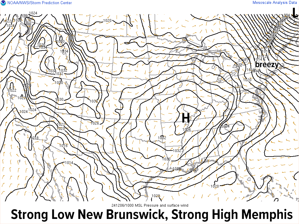
We are jammed between potent low pressure over Atlantic Canada and powerful high pressure over western Tennessee, which will keep our northwest breezy conditions up, with gusts 20-35mph this morning, slackening later.
Highs will only reach the 20s today, with lows tonight in the upper single digits to teens with a few lake effect snow showers into the Berkshires and SVT (mostly cloudy skies there, partly cloudy in the valley points south and east).
For Saturday, after a few morning Berkshire snow showers, we’ll settle out into a partly to mostly sunny day with highs in the upper 20s to mid 30s as cold northwest flow dominates one last time.
This sets the stage for Clipper system #2 to ride southeast in this flow, though this one will be weaker and a bit more north.
This means that while some light snow accumulations are possible, they should be relegated to northern MA up into SVT and SWNH with a coating to 2” possible there, and scattered coatings or just scattered snow showers south of the Rt. 2 corridor, but I will keep you updated on this for late Saturday night into Sunday morning. Lows will dip to the low to mid 20s.
After some light snow on Sunday morning, southerly flow will develop and clouds should persist, but it will be milder with highs reaching to either side of 40º, with lows in the mid to upper 20s under partly cloudy skies.
Next week looks active as well with two more systems, one Monday night and another Wednesday with highs generally in the 40s (peaking into the low 50s Wednesday) and lows in the 30s during that Monday to Wednesday stretch, before we cool back down behind the Wednesday system on Thursday to 30s for highs with fair weather.
These two systems (Monday night into Tuesday morning and Wednesday into Wednesday night) both carry potential for mixed precipitation in parts of our region, so I’ll need time to parse out those details.
In general, some mix is possible Monday night changing to rain Tuesday, and then rain Wednesday changing to mix Wednesday night, but I’ll stay on top of it and refine things in future reports/posts.
Have a great day, folks, and remember that I do still have a limited supply of 2025 weather calendars available, so if you want one or two, please click the secure link below to order…
HAIKU OF THE DAY
Alberta Clipper
You’ve provided hope’s flicker
For this snow lover
“Follow your bliss and the universe will open doors for you where there were only walls.”
― Joseph Campbell
