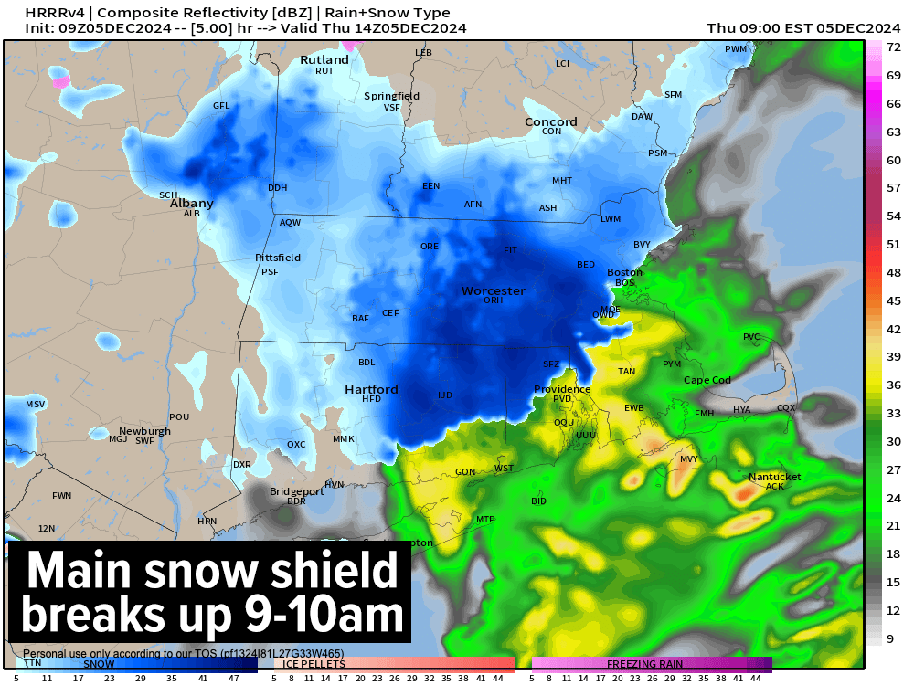
[6:43AM THURSDAY 12/5/24] SNOW SQUALL TRACKING THRU WMASS EARLY THIS MORNING, WATCH YOUR TRAVEL… WIDESPREAD 2-6” SNOW TOTALS RECEIVED, SOME SUB-2” AND ABOVE-6” AMOUNTS… HOW MUCH YOU HAVE? MAIN SNOW SHIELD ENDING THIS MORNING… WIND ADVISORIES ARE UP TODAY… SCATTERED SQUALLS / SNOW SHOWERS, WIND, AND COLD ALL INCOMING FOR LATE MORNING THROUGH AFTERNOON… GUSTS UP TO 45MPH POSSIBLE… WIND CHILLS SINGLE DIGITS BY FRIDAY MORNING… ANOTHER SUNDAY CLIPPER, BUT QUITE WEAK… MILDER AND TWO RAIN CHANCES NEXT WEEK… ACTIVE PATTERN… DAVE’S 2025 WEATHER CALENDARS CONTINUE TO ENTER THE MAIL STREAM THIS WEEK…

Still time to get one of the last-ever Weather Nut weather calendars:
(Final 2025 edition will sell out, first come first served)
~~~~~~~~~~~~~~~~~~~~~~
TABLE OF CONTENTS
* Daily Celestials (Sun/Moon Data)
* Sponsor Note
* Morning Discussion
* TIP: Scroll below for sections, or read all
~~~~~~~~~~~~~~~~~~~~~~
YOUR DAILY CELESTIALS
~~~~~~~~~~~~~~~~~~~~~~
STAR:
–OUR STAR ROSE AT: 7:03am this morning
–OUR STAR WILL SET AT: 4:18pm this evening
–TOTAL DAYLIGHT TIME: 9 hours and 15 minutes
MOON:
–OUR MOON WILL RISE AT: 11:00am this morning
–MOON RISE DIRECTION: Southeast
–OUR MOON WILL SET AT: 8:28pm tonight
–MOON SET DIRECTION: Southwest
–MOON PHASE: Waxing Crescent (10.8%)
~~~~~~~~~~~~~~~~~~~~~~
A NOTE FROM OUR SPONSOR
~~~~~~~~~~~~~~~~~~~~~~
Dave Hayes The Weather Nut is Sponsored by Individual Community Members, Patrons, and Tandem Bagel Company… No matter the weather, Tandem Bagel is always there for you at several valley locations to make your mornings brighter! With *New Pizza Bagels(!)*, along with bagels baked fresh daily (including Gluten-Free options), house-whipped cream cheese, coffee, and tons of lunch options, Tandem is the perfect quick stop for lunch, breakfast, or a coffee and bagel to go.
You can either 1) visit them in Easthampton, Northampton, Hadley, Florence, and/or West Springfield, 2) hire them to cater your next event, or 3) use their super-streamlined online ordering tool by visiting their website and clicking the “Catering” or “Order Online” links.
~~~~~~~~~~~~~~~~~~~~~~
YOUR MORNING DISCUSSION
~~~~~~~~~~~~~~~~~~~~~~
Good morning folks, it’s a cold, pretty morning out there with temps in the upper 20s to low 30s with lots of 2-6” snow totals reports from you and others.
I did hear of 8” in the northern Berkshires, and wide differences in northern CT with about an inch in Windsor but almost 5” in Stafford Springs in Tolland County.
How much do you have on the ground, and is it still snowing where you are?
I am curious about southern VT to see if any of the higher totals there came to pass, though we still do have to get through today which will feature additional snow showers and potential for squalls.
We do have one more pulse of moderate to heavier snow pushing into the Taconics of eastern NY, the central and southern Berkshires, western CT and Hampden County, tracking east-northeast before 7am.
After that, we start to wind down the main part of the precipitation shield with this storm.
However, by mid-morning onward and through the afternoon some of us will see additional scattered snow showers with potential for a snow squall or two with the incoming cold front which is slicing into NY and PA currently, headed our way.
LEARNING MOMENT
The reason for this is that colder air a mile or two above our heads will be tracking out of the west-southwest through our region, which is an abnormal direction for colder air to flow from.
The colder air aloft creates sharper temperature gradients from surface to sky, and like summer thunderstorms we can see snow squalls bubble up and drop quick inches of snow, causing rapidly changing road conditions and lowered visibility, so be aware today.
BACK TO THE REPORT
Highs will reach the mid to possibly upper 30s and then fall back after the cold front passes.
In addition, westerly wind gusts will pick up and gust 30-45mph at times this afternoon and tonight, and some isolated power outages are possible.
Wind will keep up tonight, and lows will fall into the teens to low 20s with wind chills in the single digits by Friday morning!
Friday is peak cold for this first wintry cycle, with highs only in the 20s and lows in the upper singles to teens under mostly sunny skies. Clouds may increase with a snow shower possible Friday night into Saturday morning.
Saturday sees highs in the upper 20s to mid 30s under partly sunny skies with lows in the upper teens to low 20s.
Sunday should cloud up with a weak Clipper system diving southeast into northern New England with some scattered light snow showers possible along and north of the Rt. 2 corridor in MA, SVT and SWNH. Highs will be in the 30s, with lows either side of 30º.
The Mildening commences next week with southwest flow, upper ridging setting up, and two rain chances Monday and again Wednesday with a low chance for mixed wintry precip in the western high terrain. Highs will be in the 40s to near 50º which will be a welcome feel to folks not yet ready for winter.
Have a great day, folks, I will keep you updated about changing conditions today, and remember that I do still have a limited supply of 2025 weather calendars available, so if you want one or two, please click the secure link below to order…
HAIKU OF THE DAY
Of what are we made?
Star-explosion ejecta
Fleshy consciousness
“Follow your bliss and the universe will open doors for you where there were only walls.”
― Joseph Campbell
