Still time to get one of the last-ever Weather Nut weather calendars:
(2025 edition, first come first served)
~~~~~~~~~~~~~~~~~~~~~~
TABLE OF CONTENTS
* Daily Celestials (Sun/Moon Data)
* Sponsor Note
* Morning Discussion
* TIP: Scroll below for sections, or read all
~~~~~~~~~~~~~~~~~~~~~~
YOUR DAILY CELESTIALS
~~~~~~~~~~~~~~~~~~~~~~
STAR:
–OUR STAR ROSE AT: 7:02am this morning
–OUR STAR WILL SET AT: 4:18pm this evening
–TOTAL DAYLIGHT TIME: 9 hours and 16 minutes
MOON:
–OUR MOON WILL RISE AT: 10:23am this morning
–MOON RISE DIRECTION: Southeast
–OUR MOON WILL SET AT: 7:15pm this evening
–MOON SET DIRECTION: Southwest
–MOON PHASE: Waxing Crescent (10.8%)
~~~~~~~~~~~~~~~~~~~~~~
A NOTE FROM OUR SPONSOR
~~~~~~~~~~~~~~~~~~~~~~
Dave Hayes The Weather Nut is Sponsored by Individual Community Members, Patrons, and Tandem Bagel Company… No matter the weather, Tandem Bagel is always there for you at several valley locations to make your mornings brighter! With *New Pizza Bagels(!)*, along with bagels baked fresh daily (including Gluten-Free options), house-whipped cream cheese, coffee, and tons of lunch options, Tandem is the perfect quick stop for lunch, breakfast, or a coffee and bagel to go.
You can either 1) visit them in Easthampton, Northampton, Hadley, Florence, and/or West Springfield, 2) hire them to cater your next event, or 3) use their super-streamlined online ordering tool by visiting their website and clicking the “Catering” or “Order Online” links.
~~~~~~~~~~~~~~~~~~~~~~
YOUR MORNING DISCUSSION
~~~~~~~~~~~~~~~~~~~~~~
Good morning folks, thanks for the reports yesterday evening about those snow showers that really stood up in some cases, with almost 4” reported in Lee, MA!
As for today, we will begin with a partly to mostly sunny day with highs in the 30s, but our Clipper system is already diving southeast through the Great Lakes. This means clouds will increase across the region by mid day give or take, and it will LOOK like snow is coming.
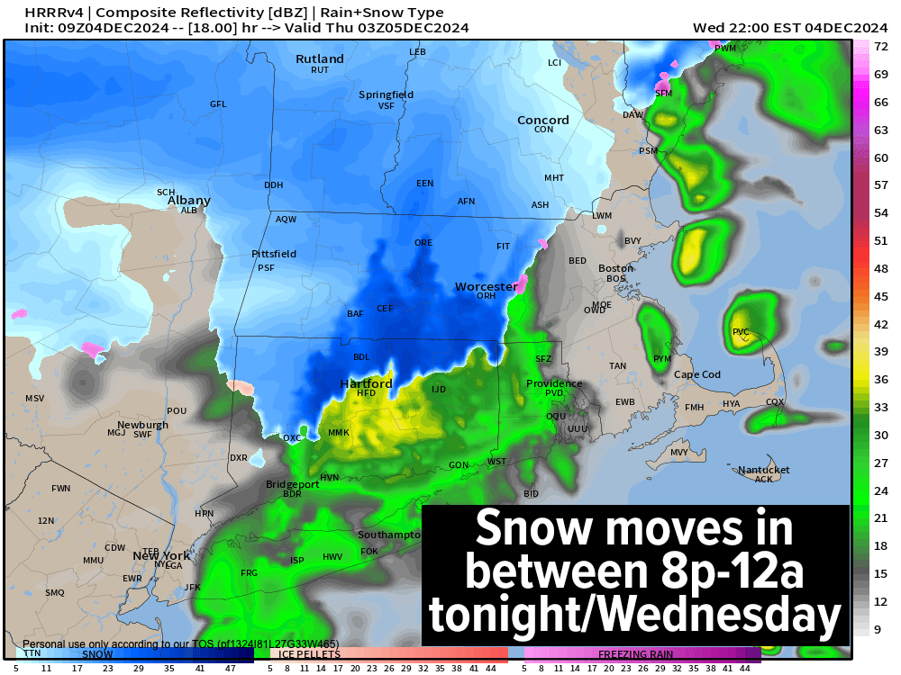
In fact, we could see a few snow or rain showers before sunset or just after as the first wave of moisture washes through, but it’s really any time after 7pm or so when snow will overspread the greater WMass region from west to east, with some rain mixed in over areas near Springfield south to Hartford.
Yes, this storm is passing to our north keeping us on its milder side with southwest flow, and that is why some rain will keep totals down in parts of northern CT like Hartford up to Windsor Locks, but the brunt of the storm will be arriving at night, and it has been cold.
This will combine to help bloom a snow shield in much of our greater WMass region between 7pm and midnight, and it will snow steadily to even briefly heavy at times overnight into Thursday morning. Lows will dip into the upper 20s to low 30s.
The Thursday morning commute will be slowed for most of us, especially along and north of the Pike, so give yourself extra time tomorrow morning. The bulk of the snow should be over by noon.
Our Clipper low center will track southeast into northern NH and western Maine before hooking east and then northeast and away as it strengthens.
This will help pull a cold front through our region Thursday afternoon with additional snow squalls possible and changing road conditions. Not only that, but as our storm deepens the pressure gradient will tighten, and we will see blustery conditions develop Thursday afternoon, night and into Friday with westerly gusts of 30-45mph at times.
This could produce blowing snow, lowered visibility, isolated power outages, and even wind chills at or briefly below zero in far northwest MA and southern VT by Friday morning with lows plummeting into the teens to low 20s.
As for snow totals, I am sticking with 2-5” for WMass, CMass, northern Litchfield County, southwest NH an eastern Windham County VT. There may be a few sub-2” amounts in the Springfield metro if rain mixes in for a while.
A coating to 2” should cover much of northern CT, and 5-10” should cover much of southern VT, the northern Berkshires, and western Franklin/Hampshire Counties, though I would lean to the lower end of that range for most of towns in this sub-region (maybe more 4-8”), with the higher range being relegated to the mountain peaks of southern VT where someone could see a fluffy foot.
Friday through Sunday look partly to mostly sunny with highs in the 20s to low 30s Friday and Saturday, and in the 30s Sunday, with lows in the teens Friday and Saturday night, and in the mid 20s Sunday night.
Friday will be the peak cold in this first real wintry pattern early in the season.
By early to mid next week, The Mildening will be underway with highs in the 40s to near 50º and a couple of chances at rain showers during the Monday to Wednesday timeframe.
Have a great day, folks, I will keep you updated about tonight’s storm, and remember that I do still have a limited supply of 2025 weather calendars available, so if you want one or two, please click the secure link below to order…
HAIKU OF THE DAY
Of what are we made?
Star-explosion ejecta
Fleshy consciousness
“Follow your bliss and the universe will open doors for you where there were only walls.”
― Joseph Campbell
