
TABLE OF CONTENTS
* Daily Celestials (Sun/Moon Data)
* Weekly Weather Nutshell
* Morning Discussion
* TIP: Scroll below for sections, or read all
~~~~~~~~~~~~~~~~~~~~~~
YOUR DAILY CELESTIALS
~~~~~~~~~~~~~~~~~~~~~~
STAR:
–OUR STAR WILL RISE AT: 7:18am this morning
–OUR STAR WILL SET AT: 4:27pm this evening
–TOTAL DAYLIGHT TIME: 9 hours and 9 minutes
MOON:
–OUR MOON WILL RISE AT: 8:02pm this afternoon
–MOON RISE DIRECTION: East-Northeast
–OUR MOON WILL SET AT: 10:25am tomorrow morning
–MOON SET DIRECTION: West-Northwest
–MOON PHASE: Waning Gibbous (88.5%)
~~~~~~~~~~~~~~~~~~~~~~
>>> A NOTE FROM OUR SPONSOR <<<
Dave Hayes The Weather Nut is Sponsored by Individual Community Members, Patrons, and Gerard, Ghazey & Bates, P.C. GGBPC is a Northampton-based law firm regarded as the voice of pragmatic and well-reasoned estate planning, elder law and tax guidance in Western Massachusetts. The firm specializes in estate planning law, and expertly handles other matters such as Elder Law, Tax Law, as well as Real Estate purchase, sales, and refinance transactions. Contact GGBPC today to see how they can help!
~~~~~~~~~~~~~~~~~~~~~~
YOUR WEEKLY WEATHER NUTSHELL
~~~~~~~~~~~~~~~~~~~~~~
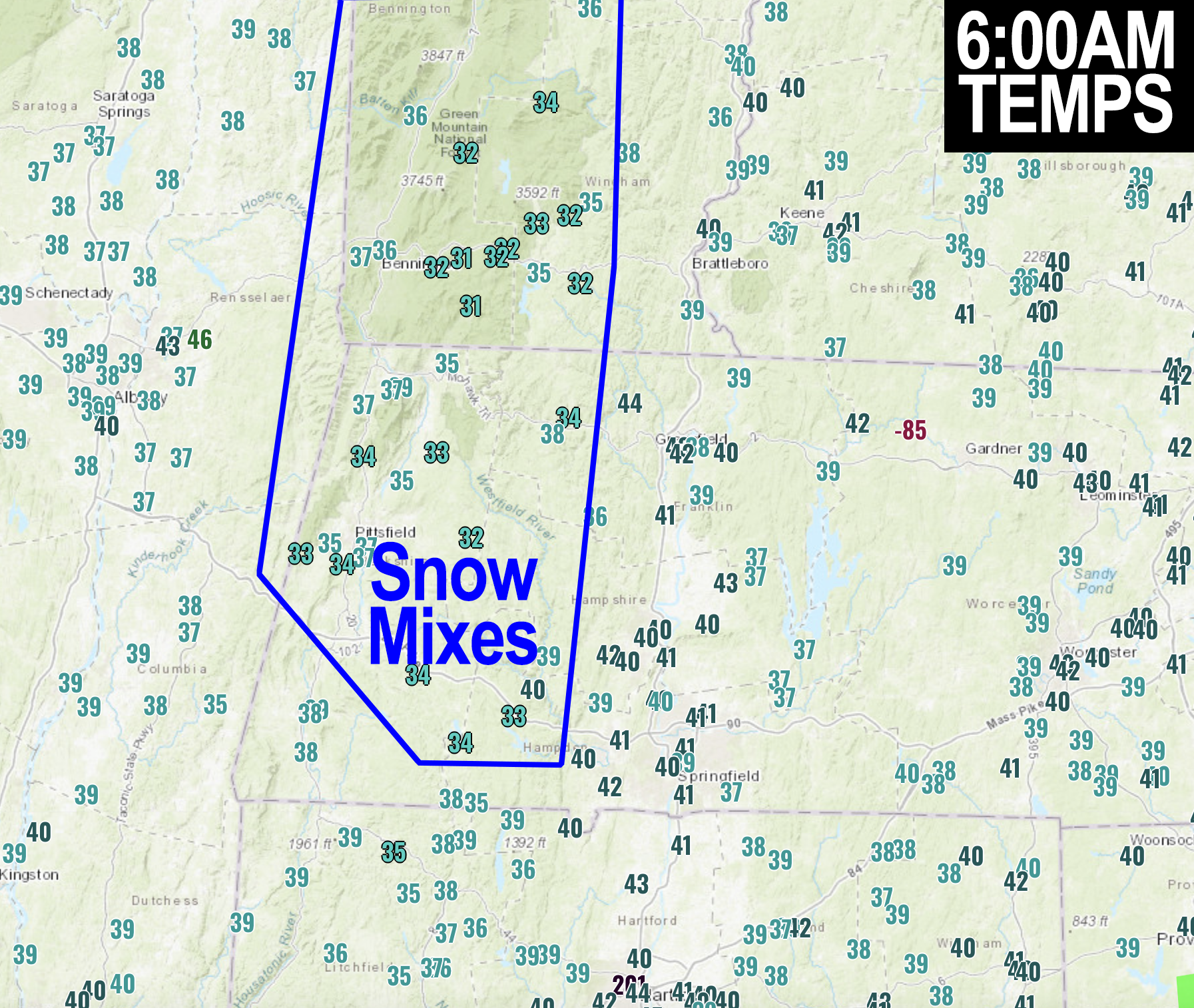
–Morning scattered rain and snow showers will quit by around mid-day, maybe last into early afternoon for CMass/NE.CT
–Some coatings to an inch are possible in parts of the Berkshires, SVT and far western hilltowns
–Otherwise, we are in a drying phase by afternoon with a cold frontal passage
–highs reach the low to perhaps mid 40s then fall back into the mid to upper 20s for lows tonight
–West-northwest winds kick up 15-25mph in gusts behind the front, leading to a blustery and drier evening
–Watch for breaking clouds and some partial sunshine late in the day, could be a nice sunset, take pics and post ’em!
–After a cold overnight, New Year’s Eve Day will feature our first fully sunny day in a long time with seasonable highs in the 30s
–New Year’s Eve will be chilly with lows in the 20s, but it will be dry, with clouds building late
–A system will track to our south on New Year’s Day, so it looks like more of a partly sunny day, with more clouds than sun near and south of the Pike with highs again in the 30s, with lows either side of 20º
–Tuesday and Wednesday will feature more sunshine and seasonably cold temps in the 35-40º range to kick off 2024
–By Thursday, I’ll be watching northern and southern stream systems approaching the region
–How these two interact will dictate whether they phase into a larger storm over New England, or remain mostly separate, with more of an Alberta Clipper type system for the WMass region with the juice staying south
–Currently I am favoring the latter setup, but I will keep an eye on the late week period and keep you updated
~~~~~~~~~~~~~~~~~~~~~~
YOUR MORNING DISCUSSION
~~~~~~~~~~~~~~~~~~~~~~
Good morning everybody, well 2023 is winding down fast now and here comes 2024. It’s strange to think how we’ll be long gone from this world when someone in 2112 might be referring back to the early 21st century, but such thoughts can help us be grateful for being here now, provided you’re not sick with one of the many virulent bug-based maladies swirling around our region right now. If that’s you, hang in there!
As for our weather, we have one final day of mostly cloudy skies with showers in the area, but this time we have some snow mixing in this morning as well, though mostly in the mountains of Berkshire and Bennington County as well as the Taconics of eastern NY. Some snow may bleed or mix into some western hilltowns or western Windham County VT, and we can’t rule out a coating to an inch or so by tonight (a few more lake effect snow showers may dot the Berkshires/SVT this eve).
This is all thanks to an upper level low finally tracking east through our region today, dragging a surface a cold front through as well.
Highs will reach the low to MAYBE mid 40s, but then our cold front will shift winds out of the west-northwest, cool us down into tonight, with most rain/snow showers ending by early to mid afternoon.
We should get some sunny breaks in the afternoon, so hopefully we’ll get a nice sunset!!
Lows tonight will drop into the 20s on decent cold air advection, which will set us up for a gorgeous final day of 2023.
Highs Sunday will be in the 30s under mostly sunny skies with light wind, and it will be dry at night as well, so all New Year’s Even plans will go off without a hitch! It’ll be near freezing at midnight, with lows ending up in the mid to upper 20s.
For New Year’s Day, a storm system steams south of us, and will throw its northern cloud shield into the southern parts of our greater WMass region, with partial sunshine generally north of the Pike, and more clouds than sun south of it with dry conditions, highs in the 30s, and lows near 20º.
Tuesday and Wednesday will feature high pressure building into the region with highs 35-40º under mostly sunny skies and lows in the 20s, so get ready for more yellow-white sky orb resplendency!
By Thursday, as mentioned in the Nutshell above, a pair of storm systems will be approaching the region, and will either phase to some degree, producing a potential wintry impact here in southern New England, or they will remain more zonal in track and separate in interaction, which could produce a more light snow or snow showery impact Thursday evening into Friday morning.
For now, I am favoring the lighter impact, but I will keep you updated as we get closer.
Have a great day and let me know if you see snow or a great sunset!
>>> BE KIND <<<
“Hello babies. Welcome to Earth. It’s hot in the summer and cold in the winter. It’s round and wet and crowded. On the outside, babies, you’ve got a hundred years here. There’s only one rule that I know of, babies: Goddamn it, you’ve got to be kind.”
–Kurt Vonnegut