
Potential winter storm late next week
TABLE OF CONTENTS
* Daily Celestials (Sun/Moon Data)
* Weekly Weather Nutshell
* Morning Discussion
* TIP: Scroll below for sections, or read all
~~~~~~~~~~~~~~~~~~~~~~
YOUR DAILY CELESTIALS
~~~~~~~~~~~~~~~~~~~~~~
STAR:
–OUR STAR WILL RISE AT: 7:18am this morning
–OUR STAR WILL SET AT: 4:26pm this evening
–TOTAL DAYLIGHT TIME: 9 hours and 8 minutes
MOON:
–OUR MOON WILL RISE AT: 6:57pm this afternoon
–MOON RISE DIRECTION: East-Northeast
–OUR MOON WILL SET AT: 10:01am tomorrow morning
–MOON SET DIRECTION: West-Northwest
–MOON PHASE: Waning Gibbous (93.9%)
~~~~~~~~~~~~~~~~~~~~~~
A NOTE FROM OUR SPONSOR
~~~~~~~~~~~~~~~~~~~~~~
Dave Hayes The Weather Nut is Sponsored by Individual Community Members, Patrons, and Tandem Bagel Company… No matter the weather, Tandem Bagel is always there for you at several valley locations to make your mornings brighter! With bagels baked fresh daily (including Gluten-Free options), house-whipped cream cheese, coffee, and tons of lunch options, Tandem is the perfect quick stop for lunch, breakfast, or a coffee and bagel to go. Find them in Easthampton, Northampton, Hadley, Florence, and West Springfield, or use their super-streamlined online ordering tool by visiting their website.
~~~~~~~~~~~~~~~~~~~~~~
YOUR WEEKLY WEATHER NUTSHELL
~~~~~~~~~~~~~~~~~~~~~~
–A wave dives southeast toward New England bringing more scattered showers today tracking west to east
–Highs will reach the mid to upper 40s under cloudy skies
–A few more showers are expected tonight with lows in the upper 30s
–A cold front drops south into the area tomorrow as an upper low presses east and out to sea
–This will lower temps and cause Saturday morning showers to flip to or mix with snow in SVT and the highest terrain of northwest MA where coatings are possible by Saturday afternoon
–Some partial sunshine is possible by afternoon with highs in the low to mid 40s, and lows in the mid to upper 20s
–By Sunday / New Year’s Eve we should see high pressure nudging into the region with mostly sunny skies and highs in the upper 30s
–New Year’s Eve looks clear, dry, and colder with lows in the mid to upper 20s, so fully supportive for going to First Night Northampton (where I’m performing music with King Radio at St. John’s Episcopal Church on Elm St. at 7pm) or other plans
–New Year’s Day looks dry and partly sunny with highs in the upper 30s to low 40s, so a good day to rest and relax or take a walk
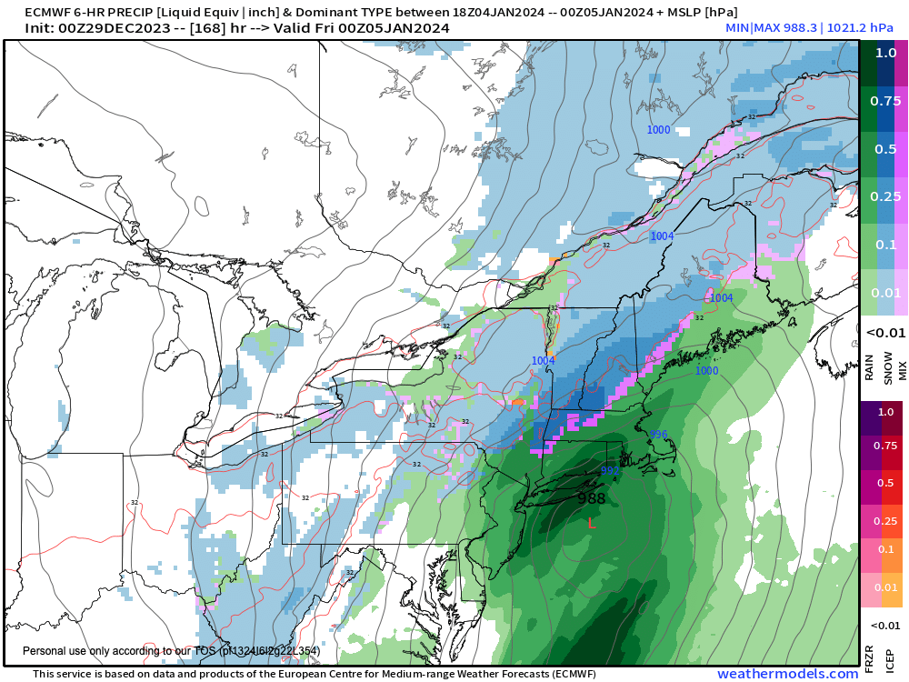
–The rest of the week looks cool and dry, but by later Thursday or Friday we may have another storm on our hands, and it could have wintry impacts, so stay tuned for updates
~~~~~~~~~~~~~~~~~~~~~~
YOUR MORNING DISCUSSION
~~~~~~~~~~~~~~~~~~~~~~
Good morning everybody, fog is less of a concern this morning, but there are a couple of denser areas in Cheshire County NH down into eastern Franklin over into northern CMass, for example.
Otherwise, we have scattered showers tracking through the WMass region this early morning, so some of us will get wet.
This will continue off and on during the day and into this evening with highs in the 40s under cloudy skies, and with lows in the upper 30s as we get set to traverse one more Day of Meh.
Colder air will start to bleed south later tonight and iinto Saturday as a cold front approaches, and this should flip rain to snow showers in parts of southwest VT and possibly the highest terrain in far northwest MA where fresh coatings are more likely than not, and maybe up to an inch or so in eastern Bennington County or Mt. Snow/Stratton.
Saturday morning snow and rain showers clear the region, and some partial sunshine will break out in the afternoon, hopefully, and start to clear this air mass out to sea.
Highs will reach the low to mid 40s tomorrow with lows in in the mid to upper 20s as we dry out.
New Year’s Eve and Day look lovely, with partial to full sunshine, albeit cooler with highs in the mid 30s to low 40s and lows in the 20s, which will be fully supportive for 2023’s final holiday weekend.
Tuesday through Thursday looks like fair weather to me, with highs generally in the mid 30s to low 40s and lows in the 20s, but by late week there are some signals that cold-enough air to our north may meet up with a southern stream system that tracks east-northeast toward the Mid-Atlantic coast which could bring snow and rain by Friday, so stay tuned for updates, and have a great day!
>>> BE KIND <<<
“Hello babies. Welcome to Earth. It’s hot in the summer and cold in the winter. It’s round and wet and crowded. On the outside, babies, you’ve got a hundred years here. There’s only one rule that I know of, babies: Goddamn it, you’ve got to be kind.”
–Kurt Vonnegut