
TABLE OF CONTENTS
* Daily Celestials (Sun/Moon Data)
* Weekly Weather Nutshell
* Morning Discussion
* TIP: Scroll below for sections, or read all
~~~~~~~~~~~~~~~~~~~~~~
YOUR DAILY CELESTIALS
~~~~~~~~~~~~~~~~~~~~~~
STAR:
–OUR STAR WILL RISE AT: 7:17am this morning
–OUR STAR WILL SET AT: 4:25pm this evening
–TOTAL DAYLIGHT TIME: 9 hours and 8 minutes
MOON:
–OUR MOON WILL RISE AT: 5:51pm this afternoon
–MOON RISE DIRECTION: Northeast
–OUR MOON WILL SET AT: 9:33am tomorrow morning
–MOON SET DIRECTION: Northwest
–MOON PHASE: Waning Gibbous (97.6%)
~~~~~~~~~~~~~~~~~~~~~~
A NOTE FROM OUR SPONSOR
~~~~~~~~~~~~~~~~~~~~~~
Dave Hayes The Weather Nut is Sponsored by Individual Community Members, Patrons, and Tandem Bagel Company… No matter the weather, Tandem Bagel is always there for you at several valley locations to make your mornings brighter! With bagels baked fresh daily (including Gluten-Free options), house-whipped cream cheese, coffee, and tons of lunch options, Tandem is the perfect quick stop for lunch, breakfast, or a coffee and bagel to go. Find them in Easthampton, Northampton, Hadley, Florence, and West Springfield, or use their super-streamlined online ordering tool by visiting their website.
~~~~~~~~~~~~~~~~~~~~~~
YOUR WEEKLY WEATHER NUTSHELL
~~~~~~~~~~~~~~~~~~~~~~
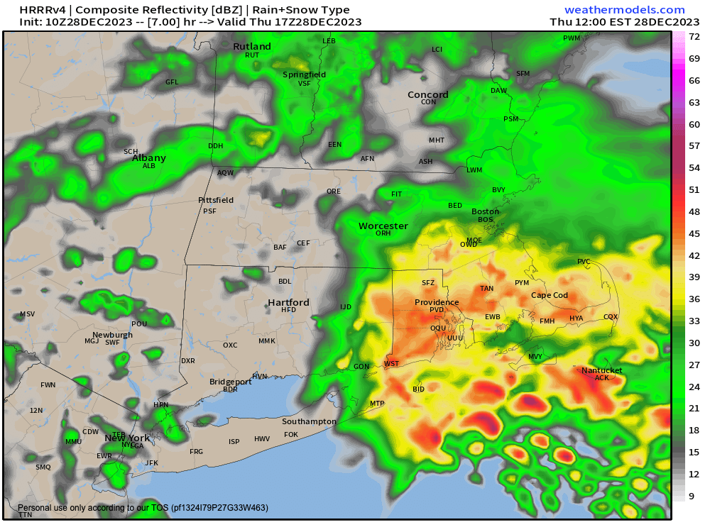
–Steadier rain departs WMass, SVT, SWNH, northwest and north-central CT this early morning, with scattered showers remaining later on
–A final burst of heavier rain should develop and lift through northeast CT and CMass by late morning into mid day
–The trend overall today is less rain, dry/cloudy periods, and some scattered showers at times
–Highs kind of hang where they are now in this stagnant pattern, in the mid to upper 40s, with lows tonight only in the upper 30s to low 40s with patchy fog possible
–Friday into the first part of Saturday sees the upper low track east into the region with additional scattered showers
–Highs will be in the mid 40s again Friday, then near 40º on Saturday with a few high terrain snow showers in the morning by that time
–Cold front finally pushes through, and clears this malignant maladacious morass of meteorological moribundity out of here Saturday night into Sunday!
–Colder Sunday into early next week with highs in the 35-40º range and lows in the 20s with increasing sunshine for New Year’s Day and a dry New Year’s Eve!
~~~~~~~~~~~~~~~~~~~~~~
YOUR MORNING DISCUSSION
~~~~~~~~~~~~~~~~~~~~~~
Good morning everybody, if you didn’t see it in the Nutshell above, I coined a new, elegant, and easy-to-remember term for this current air mass:
Malignant maladacious morass of meteorological moribundity.
I know, I know, it rolls right off of the tongue just like the Western Mass Snow Lovers’ Triangle of Disappointment.
While the former is replete with an abundance of alliteration, they both clearly illustrate that I should have been a marketer or advertising copywriter, given my succinct word usage.
Alas, the late comedian Bill Hicks would instead likely have applauded my detour into my weather nutdom, so I’ve got that going for me!
As for our weather, we continue in this stagnant air mass, but the steadier rainfall will push out of the WMass region this morning into early afternoon, quitting first in the west (Berkshires / SVT / Valley), and later in the east (CMass / Northeast CT).
At the end, most of us will have received about a third of an inch up to an inch or inch and a half down in the Springfield metro northern CT.
Highs will reach the mid to upper 40s today, and as I said, after the WMass rain this morning, and a burst of heavier rain in northeast CT and CMass around mid day, we will be tapering to dry periods with some scattered showers at times. Lows will drop to near 40º with patchy fog tonight.
Friday and Saturday represent the ending portion of our stagnant air mass, with the upper low finally tracking east and through our region during this timeframe.
Highs will generally reach the mid 40s Friday with some scattered showers, which should continue into the night with lows in the mid to upper 30s as the upper low continues moving through the region.
By Saturday, colder air will be on our doorstep with a cold front that will be pushing through at night.
Before it does, a few rain or snow showers will be possible with highs in the upper 30s to mid 40s and lows near freezing.
New Year’s Eve and Day look much better with drying and colder air moving into the region with highs in the mid 30s to low 40s under partly to mostly sunny skies, with lows in the 20s.
Into the middle of next conditions look similar to New Year’s Day, and by the next weekend into the 2nd week of January there are some signals of a colder conditions and a bit more storminess, so I will be watching to see if those start to shake hands over New England and possibly produce some wintry weather, so stay tuned for updates, and have a great day!
>>> BE KIND <<<
“Hello babies. Welcome to Earth. It’s hot in the summer and cold in the winter. It’s round and wet and crowded. On the outside, babies, you’ve got a hundred years here. There’s only one rule that I know of, babies: Goddamn it, you’ve got to be kind.”
–Kurt Vonnegut