
TABLE OF CONTENTS
* Daily Celestials (Sun/Moon Data)
* Weekly Weather Nutshell
* Morning Discussion
* TIP: Scroll below for sections, or read all
~~~~~~~~~~~~~~~~~~~~~~
YOUR DAILY CELESTIALS
~~~~~~~~~~~~~~~~~~~~~~
STAR:
–OUR STAR WILL RISE AT: 7:17am this morning
–OUR STAR WILL SET AT: 4:24pm this evening
–TOTAL DAYLIGHT TIME: 9 hours and 7 minutes
MOON:
–OUR MOON WILL RISE AT: 3:48pm this afternoon
–MOON RISE DIRECTION: Northeast
–OUR MOON WILL SET AT: 8:13am tomorrow morning
–MOON SET DIRECTION: Northwest
–MOON PHASE: Full Cold Moon
~~~~~~~~~~~~~~~~~~~~~~
A NOTE FROM OUR SPONSOR
~~~~~~~~~~~~~~~~~~~~~~
Dave Hayes The Weather Nut is Sponsored by Individual Community Members, Patrons, and Tandem Bagel Company… No matter the weather, Tandem Bagel is always there for you at several valley locations to make your mornings brighter! With bagels baked fresh daily (including Gluten-Free options), house-whipped cream cheese, coffee, and tons of lunch options, Tandem is the perfect quick stop for lunch, breakfast, or a coffee and bagel to go. Find them in Easthampton, Northampton, Hadley, Florence, and West Springfield, or use their super-streamlined online ordering tool by visiting their website.
~~~~~~~~~~~~~~~~~~~~~~
YOUR WEEKLY WEATHER NUTSHELL
~~~~~~~~~~~~~~~~~~~~~~
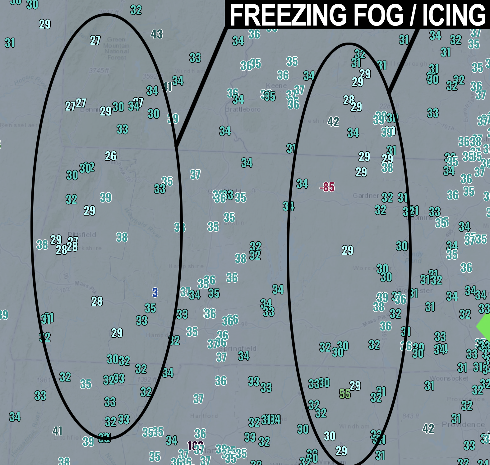
–Dense Fog Advisories are up everywhere this morning
–Freezing fog is noted in spots with temps in the upper 20s to low 30s in some areas
–Icy travel is possible, proceed with caution
–Fog should lift later this morning and temps will crest into the upper 40s for highs under mostly cloudy skies
–Fog redevelops again tonight, lows in the mid to upper 30s
–Cloudy tomorrow with a storm moving in with highs in the upper 40s again
–Rain begins by very late afternoon into the early evening, lasting through Thursday morning
–Up to an inch of rainfall looks probable, flooding is not expected
–Rain abates Thursday afternoon, highs upper 40s again
–Friday and Saturday feature an upper low and possibly a second weaker surface storm
–Scattered rain showers turning to snow showers Saturday
–Colder this weekend into Monday, highs mid to upper 30s, lows 20s
–New Year’s Eve and Day look calm and fair
~~~~~~~~~~~~~~~~~~~~~~
YOUR MORNING DISCUSSION
~~~~~~~~~~~~~~~~~~~~~~
Good morning everybody, the Nutshell is going to cover the main weather happenings for this morning, but I will write up a discussion and post it later this afternoon, and in the comments below this post once I publish it.
I do love telling the local weather story, but I’ve been off my mark with recent sickness, and for that I apologize.
I am starting to feel better, and will “stand back up” in short order, but for now *proceed with caution this morning due to freezing fog* potential.
There are two pockets of our region with temps at freezing or below, and fog is dense, so some icing is likely, whether on your decks, cars, or even some sidewalks and roads.
This will improve as the morning wears on and temps come up. Have a great day!
>>> BE KIND <<<
“Hello babies. Welcome to Earth. It’s hot in the summer and cold in the winter. It’s round and wet and crowded. On the outside, babies, you’ve got a hundred years here. There’s only one rule that I know of, babies: Goddamn it, you’ve got to be kind.”
–Kurt Vonnegut