
>>> YOUR DAILY CELESTIALS <<<
STAR:
–OUR STAR ROSE AT: 7:16am this morning
–OUR STAR WILL SET AT: 4:23pm this evening
–TOTAL DAYLIGHT TIME: 9 hours and 7 minutes
MOON:
–OUR MOON WILL RISE AT: 2:14pm this afternoon
–MOON RISE DIRECTION: Northeast
–OUR MOON WILL SET AT: 6:14am tomorrow morning
–MOON SET DIRECTION: Northwest
–MOON PHASE: Waxing Gibbous (93.1%)
~~~~~~~~~~~~~~~~~~~~~~
>>> A NOTE FROM OUR SPONSOR <<<
Dave Hayes The Weather Nut is Sponsored by Individual Community Members, Patrons, and Gerard, Ghazey & Bates, P.C. GGBPC is a Northampton-based law firm regarded as the voice of pragmatic and well-reasoned estate planning, elder law and tax guidance in Western Massachusetts. The firm specializes in estate planning law, and expertly handles other matters such as Elder Law, Tax Law, as well as Real Estate purchase, sales, and refinance transactions. Contact GGBPC today to see how they can help!
~~~~~~~~~~~~~~~~~~~~~~
>>> DAVE’S WEEKLY WEATHER NUTSHELL <<<
–A weak wave is tracking east into and through the regioin today, tonight and early Christmas morning
–This is a low impact event, with the main impact being this morning through about 9am or 10am
–Patchy black ice may form, especially on raised surfaces like bridges and overpasses
–Light areas of freezing rain or freezing drizzle will develop in some areas, so watch for slick spots this morning when traveling
–Temps will climb out of the low to mid 30s this morning, with highs in the upper 30s to low 40s under mostly cloudy skies with a few showers possible
–For Christmas Eve a few light showers are possble, otherwise it will be dry with lows in the mid 30s and some patchy fog possible
–For Christmas Day, we could see a few isolated showers in the morning, otherwise it just be a mostly cloudy day with highs in the low to mid 40s with partial sunshine possible later in the afternoon
–Christmas Night lows will drop into the mid 30s
–Southwest flow develops Tuesday through Thursday highs climbing into the mid to upper 40s, and possibly reaching 50º by Thursday
–After a dry Tuesday under partly sunny to mostly cloudy skies, another storm system will track into the Ohio Valley and spawn a secondary low that runs into New England Wednesday night
–This will push more rainfall into the region for the second half of Wednesday into Thursday with up to an inch of rainfall possible
–Behind that storm on Friday, temps will cool down into the weekend as we head toward New Year’s Eve, which looks dry at the moment
–The first week in January looks colder overall, so we’ll see if that trend holds
~~~~~~~~~~~~~~~~~~~~~~
>>> MORNING DISCUSSION <<<
Good morning everybody, once again the Nutshell is going to have to do it for conveying the sensible weather impacts, as I need to rest some more, but wanted to get the morning post out as there could be some icy areas of travel through today’s mid-morning period.
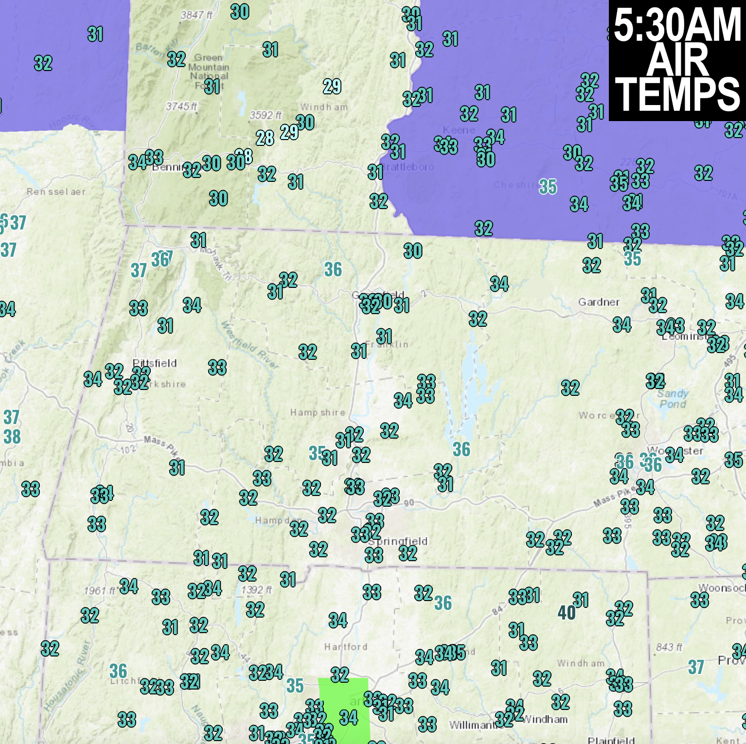
Please take it easy on the road ways, especially in elevated parts of the WMass and northwest CT regions, as well as southern VT, and southwest NH where a Winter Weather Advisory is up until 9am.
Many areas are between 30-32º this early morning, with some upper 20s in SVT, so watch for slick spots!
Have a great day, and a safe and enjoyable Christmas Eve if you’re celebrating!
>>> BE KIND <<<
“Hello babies. Welcome to Earth. It’s hot in the summer and cold in the winter. It’s round and wet and crowded. On the outside, babies, you’ve got a hundred years here. There’s only one rule that I know of, babies: Goddamn it, you’ve got to be kind.”
–Kurt Vonnegut