
>>> YOUR DAILY CELESTIALS <<<
STAR:
–OUR STAR ROSE AT: 7:16am this morning
–OUR STAR WILL SET AT: 4:22pm this evening
–TOTAL DAYLIGHT TIME: 9 hours and 6 minutes
MOON:
–OUR MOON WILL RISE AT: 1:39pm this afternoon
–MOON RISE DIRECTION: East-Northeast
–OUR MOON WILL SET AT: 5:03am tomorrow morning
–MOON SET DIRECTION: West-Northwest
–MOON PHASE: Waxing Gibbous (87.3%)
~~~~~~~~~~~~~~~~~~~~~~
>>> A NOTE FROM OUR SPONSOR <<<
Dave Hayes The Weather Nut is Sponsored by Individual Community Members, Patrons & Gerard, Ghazey & Bates, P.C. GGBPC is a Northampton-based law firm regarded as the voice of pragmatic and well-reasoned estate planning, elder law and tax guidance in Western Massachusetts. The firm specializes in estate planning law, and expertly handles other matters such as Elder Law, Tax Law, as well as Real Estate purchase, sales, and refinance transactions. Contact GGBPC today to see how they can help!
~~~~~~~~~~~~~~~~~~~~~~
>>> DAVE’S WEEKLY WEATHER NUTSHELL <<<
–Sunshine early will fade behind increasing clouds
–It will be seasonably cold with highs in the mid to upper 30s
–High pressure scoots off to the east tonight, increasing southerly flow a bit
–This combined with a shortwave moving in from the west will produce some scattered light snow, sleet or rain showers tonight into tomorrow morning
–Freezing drizzle also possible and this could create some black icing late tonight into tomorrow morning
–Lows tonight will sit down around the freezing mark
–For Sunday, a mostly cloudy day is now expected with highs in the upper 30s to low 40s with some morning mixed showers possible
–On Christmas Eve we should again see lows in the low 30s
–Christmas Day is a drying day, but there likely will be some morning cloudiness around with milder highs in the mid 40s, with potential for some afternoon sunny breaks
–Christmas Night should produce partly cloudy skies with lows in the mid 30s, dry
–A mostly cloudy week lies ahead after the holiday and before New Years Day
–Tuesday is milder as southerly flow develops with highs in the mid to upper 40s under mostly cloudy skies
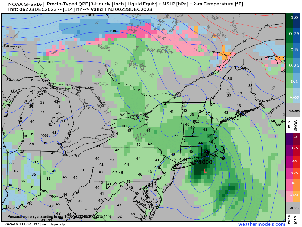
–Thereafter, there are timing discrepancies with when our coastal low will bring more rainfall
–This could be as early as Tuesday night arrival, or as late as a Wednesday late afternoon arrival
–It looks showery for Wednesday and Thursday with mild temps well into the 40s
–Then sometime by Friday or so we should cool down and clear out as the storm departs the region
~~~~~~~~~~~~~~~~~~~~~~
>>> MORNING DISCUSSION <<<
Good morning everybody, I’m still under the weather and need to rest. Obviously if our weather were more active I’d be diving into the details with more specificity and would be all over it (I once posted an update in the midst of a kidney stone attack, unbeknownst to anyone) but with this relatively benign setup, the Weekly Weather Nutshell will do most of the talking for the time being.
The main issues are that we could see some light freezing drizzle or rain later tonight into tomorrow morning, so watch for patches of black ice.
In addition, Christmas Eve and Day look mostly dry, especially the 25th, and our next chance for substantial rainfall/precip is sometime between Tuesday afternoon and Thursday afternoon and I will keep you updated as the timing of arrival and departure becomes more clear.
For now, it’s a busy weekend, so be kind to each other, hold the door for somebody, and keep taking your Vitamin C and drinking lots of fluids because there’s a lot of bugs making a lot of people ill this late part of 2023, try not to be one of them, no fun.
>>> BE KIND <<<
“Hello babies. Welcome to Earth. It’s hot in the summer and cold in the winter. It’s round and wet and crowded. On the outside, babies, you’ve got a hundred years here. There’s only one rule that I know of, babies: Goddamn it, you’ve got to be kind.”
–Kurt Vonnegut