
My 9th Edition, 2023 Weather Wall Calendars are still available if you are a later-calendar-shopper.
——————————-
DAVE’S WEEKLY WEATHER NUTSHELL
–Mostly cloudy today
–Rain this morning lets up by mid to late morning, resumes afternoon
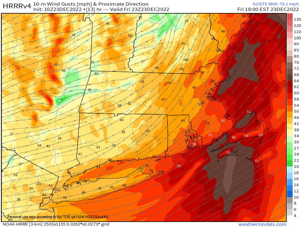
–Southerly wind gusts generally 30-50mph this morning, some exceed 50mph, with gusts up to 60mph or so in SVT
–Scattered outages continue
–Cold front comes through early to mid afternoon along with more showers and downpours, changing to snow
–Wind shifts to southwest and gusts 30-50mph, additional outages
–Temps crash from the 50s through the 20s into the single digits overnight with wind slackening to gusts to 35mph by morning and into Saturday
–Cold and fair this weekend, highs 20s lows singles, but less wind Christmas Day
–Temps climb back to the 30s by mid next week, then warming by late next week into first week of January
Now then, before we jump into the weather discussion/details below, let’s check a note from our local and delicious sponsor, #TandemBagelCo, with their newest location in West Springfield, MA.
——————–
A NOTE FROM OUR SPONSOR:
DHTWN Is Sponsored by Members, Patrons & Tandem Bagel Company: No matter the weather, Tandem Bagel is always there for you at several valley locations to make your mornings brighter! With bagels baked fresh daily (including Gluten-Free options), house-whipped cream cheese, coffee, and tons of lunch options, Tandem is the perfect quick stop for lunch, breakfast, or a coffee and bagel to go. Find them in Easthampton, Northampton, Hadley, Florence, and West Springfield, or use their super-streamlined online ordering tool by visiting their website.
——————————————-
***DHTWN DAILY WEATHER REPORT***
——————————————-
NWS ALERTS
–Wind Advisories much of the WMass region
–High Wind Warning Bennington County
–Flood Warning southwest NH
–Wind Chill Advisories for CT, MA and VT locations bordering NY state
DHTWN REMINDER
–The odds of being a human is 1 in 400,000 billion… make it count, even in a small way (see Kurt Vonnegut quote at end of post)
DAILY CELESTIAL (STAR):
–OUR STAR ROSE AT: 7:16am this morning
–OUR STAR WILL SET AT: 4:22pm this evening
–TOTAL DAYLIGHT TIME: 9 hours and 6 minutes
NIGHTLY CELESTIAL (MOON):
–OUR MOON WILL SET AT: 4:26pm this afternoon
–OUR MOON WILL RISE AT: 8:52am tomorrow morning
–MOON SET DIRECTION: Southwest
–MOON RISE DIRECTION: Southeast
–MOON PHASE: Waxing Crescent (0.1%)
———————-
DAILY TERRESTRIAL (ZoneCast)
ZONE 1 (Northern Region)
Southern VT, Southwest NH, N. Taconics NY
–High Temps: Mid to Upper 40s
–Low Temps: Single digits
–Wind: Southerly gusts up to 55mph this morning, then southwesterly gusts up to 50mph this afternoon
–Skies: Mostly Cloudy
–Precipitation: Scattered Rain into the afternoon and Snow showers later
ZONE 2 (Central Region)
WMass, N. CMass, N. Litchfield County, C./S. Taconics NY
–High Temps: Low to Mid 50s
–Low Temps: Single digits
–Wind: Southerly gusts up to 50mph this morning, then southwesterly gusts up to 50mph this afternoon
–Skies: Mostly Cloudy
–Precipitation: Scattered Rain into the afternoon and Snow showers later
ZONE 3 (Southern Region)
S. CMass, S. Litchfield County, NC.CT, & NE.CT
–High Temps: Mid to Upper 50s
–Low Temps: Single digits to low 10s
–Wind: Southerly gusts up to 55mph this morning, then southwesterly gusts up to 50mph this afternoon
–Skies: Mostly Cloudy
–Precipitation: Scattered Rain into the afternoon and Snow showers later
———————-
WHERE’S DAVE?
–I’ve been reporting our weather daily here for almost 10 years
–Sign up for my free weekly newsletter here: https://westernmassweather.com/homepage/dhtwn-nutletter-signup/
–Please visit my this FB page via the app or web like selecting a channel you want to tune into if I’m not auto-kissing your screens
–I’m always here daily, so keep stopping by!
———————-
MORNING DISCUSSION
Good morning everybody, we had a burst of wind blow through earlier which knocked out power for some of us in WMass/CMass up into SVT, but especially northern CT where about 30000 are without power right now.
The last burst of morning rain is moving through as I type (before 7am) and it will be gusty at times out of the south. We’ve seen peak gusts close to 50mph so far.
Expect scattered showers this morning with gusty southerly winds, and then we look to the afternoon for our cold frontal passage.
This is going to be a memorable on, as it will drop temps from where they are now (mid to upper 50s in some cases) down into the single digits overnight, which is up to a 50º drop in 24 hours, which doesn’t happen very often!
Before that, our cold front redevelops more showers, some heavy, and maybe a thunderstorm by late morning into early to mid afternoon, after a bit of a lull into the mid-morning after this early morning batch of rain moves through.
Then the cold front comes through about mid-afternoon and wind will shift from the south to southwest and gust 30-50mph, when a new round of outages may occur.
In addition, temps will drop rapidly and into the 20s and 30s by sunset or just thereafter, with rain showers changing to snow showers and bringing new coatings to some of us.
This will combine with dropping temps to potentially cause slippery travel for some, especially if some of these snow showers are more robust than modeled.
PLEASE NOTE: BE VERY CAREFUL regarding rapidly changing weather conditions and their affect on roads ways this late afternoon and evening. Be more alert than normal this afternoon and evening when driving, as many others WON’T be, and you can hopefully avoid any problems that might arise.
Snow showers abate later on, and we’re left with slackening wind but still-breezy conditions overnight as temps continue to gust 25-40mph at times.
With temps crashing into the single digits, wind chill readings will drop to 10 to 25 BELOW zero, so those late-night or early morning dog or human walks are going to need to be accompanied by massive amounts of bundling up!
High Saturday will only reach the mid teens to low 20s with southwest wind gusting to 30mph at times, and with lows in the single digits as wind slackens further.
Christmas Day is still breezy, but less than Saturday and with highs in the low to mid 20s and lows again in the single digits.
Fair weather dominates with high pressure next week with moderating temps through the 20s Monday and Tuesday and into the 30s Wednesday and Thursday, and potentially well into the 40s by Friday with partly to mostly sunny skies the whole way, sans a few mid-week showers of snow or rain.
Have a great day, stay alert, and I will update later as our cold front moves in… if you missed the order deadline I still have my 2023 weather calendars with WMass photos at the link below: I won’t be doing one next year, so get ’em while you can!
Follow me on Twitter while it’s still a thing.
AND REMEMBER…
“Hello babies. Welcome to Earth. It’s hot in the summer and cold in the winter. It’s round and wet and crowded. On the outside, babies, you’ve got a hundred years here. There’s only one rule that I know of, babies: Goddamn it, you’ve got to be kind.”
–Kurt Vonnegut