
Strong low pressure in NY state Friday
——————————-
DAVE’S WEEKLY WEATHER NUTSHELL
–High pressure builds into the region with fair weather today and tomorrow, seasonable cool temps
–Winds gust 10-20mph first bit of today, then slacken
–Radiational cooling maximizes tonight leading to a very cold night in the low teens, upper singles in the high terrain possible
–Nice sunrise potential for Thursday morning then clouds build into the afternoon
–Depending on precipitation onset, should start as snow or sleet in the high terrain of the Berkshires, western hilltowns, SVT, and rain elsewhere
–Everyone goes to rain as a powerful Midwest and Great Lakes Blizzard cranks up with rapidly deepening low pressure
–This sends strong southerly flow surging into New England, everyone goes to rain, and it rains hard at times on Friday
–Outages expected in spots, as winds gust 40-60mph, Wind Advisories likely get hoisted, possible High Wind Warnings too
–River flooding is possible as well with mild air in the 50s and snow melt, along with rainfall of 1-3″ total
–We may briefly end as snow Friday night as cold air comes CRASHING through the region, shifting southerlies to westerlies with gusts up to 40mph
–Flash freeze very possible, making travel difficult from some Vermont and western MA country dwellers, especially where snow pack is deep right now
–Arctic cold and blustery Christmas Eve and Christmas Day, but fair weather
–Clipper with light snow possible by Tuesday
Now then, before we jump into the weather discussion/details below, let’s check a note from our local and delicious sponsor, #TandemBagelCo, with their newest location in West Springfield, MA.
——————–
A NOTE FROM OUR SPONSOR:
DHTWN Is Sponsored by Members, Patrons & Tandem Bagel Company: No matter the weather, Tandem Bagel is always there for you at several valley locations to make your mornings brighter! With bagels baked fresh daily (including Gluten-Free options), house-whipped cream cheese, coffee, and tons of lunch options, Tandem is the perfect quick stop for lunch, breakfast, or a coffee and bagel to go. Find them in Easthampton, Northampton, Hadley, Florence, and West Springfield, or use their super-streamlined online ordering tool by visiting their website.
——————————————-
***DHTWN DAILY WEATHER REPORT***
——————————————-
NWS ALERTS
None
DHTWN REMINDER
–The odds of being a human is 1 in 400,000 billion… make it count, even in a small way (see Kurt Vonnegut quote at end of post)
DAILY CELESTIAL (STAR):
–OUR STAR ROSE AT: 7:14am this morning
–OUR STAR WILL SET AT: 4:21pm this evening
–TOTAL DAYLIGHT TIME: 9 hours and 7 minutes
NIGHTLY CELESTIAL (MOON):
–OUR MOON WILL SET AT: 1:58pm this afternoon
–OUR MOON WILL RISE AT: 5:15am tomorrow morning
–MOON SET DIRECTION: West-Southwest
–MOON RISE DIRECTION: East-Southeast
–MOON PHASE: Waning Crescent (11.8%)
———————-
DAILY TERRESTRIAL (ZoneCast)
ZONE 1 (Northern Region)
Southern VT, Southwest NH, N. Taconics NY
–High Temps: Low to Mid 30s
–Low Temps: Upper Singles to Low 10s
–Wind: Westerly gusts up to 10-20mph early, then lighter
–Skies: Mostly Cloudy Bennington area early, then Mostly Sunny
–Precipitation: None
ZONE 2 (Central Region)
WMass, N. CMass, N. Litchfield County, C./S. Taconics NY
–High Temps: Low to Mid 30s
–Low Temps: Low to Mid 10s
–Wind: Westerly gusts up to 10-20mph early, then lighter
–Skies: Mostly Cloudy Berkshires early, then Mostly Sunny
–Precipitation: None
ZONE 3 (Southern Region)
S. CMass, S. Litchfield County, NC.CT, & NE.CT
–High Temps: Mid to Upper 30s
–Low Temps: Mid to Upper 10s
–Wind: Westerly gusts up to 20-30mph
–Skies: Mostly Sunny
–Precipitation: None
———————-
WHERE’S DAVE?
–*I’ve been reporting our weather daily here and at https://www.westernmassweather.com for almost 10 years*
–Please visit my this FB page via the app or web like selecting a channel you want to tune into if I’m not auto-kissing your screens
–I’m always here daily, so keep stopping by!
———————-
MORNING DISCUSSION
Good morning everybody, we have another couple of tranquil, mostly sunny days ahead, and Thursday during the daylight hours won’t be stormy either, but Thursday night through Friday into the evening is going to rip around here, most likely, with rain heavy at times, strong southerly winds will knock out power for some with tree damage given southeasterly gusts of 40-60mph, along with some stream or river flooding being possible, and a flash freeze being probable by early Saturday morning.
For today, high pressure builds into the region and any westerly breezes this morning should slacken with time this afternoon and become calm to light overnight.
Highs will reach lower to mid 30s north and mid to upper 30s south (my region covers SVT/SWNH down into WMass/CMass down into northern CT).
For tonight, high pressure pushes into the region and winds die down. Given dry air, low to no wind and mostly clear skies, radiational cooling will maximizes as any “heat” radiates out into the void of Space from which everything sprang forth in this Universe, which for us means lows dive into the upper singles to mid/upper teens from north to south.
Wednesday looks lovely with sunshine and highs in the low to upper 30s with high pressure exiting away from the region. As it does so, clouds build into the region overnight with lows in the teens.
Thursday could feature a lovely sunrise, and then overcast skies developing with highs in the mid 30s to low 40s, with rain showers by evening possibly starting as snow or sleet in far northwest MA and southern VT where light accumulations are possible before everywhere flips to rain overnight.
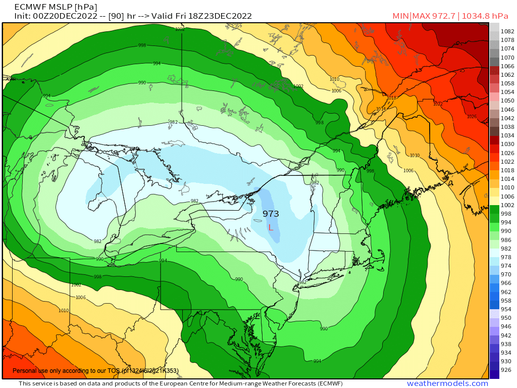
What will become the Great Lakes Blizzard of 2022 in the history books (not Storm Dumb Dumb like some outlets will name it) will by Friday morning developing rapidly along the edge of a massive Arctic outbreak that is spilling into the center and center-east of the United States.
Since storms like to form along baroclinic boundaries (i.e. boundaries of great temperature contrast) this one will deepen and undergo bombogenesis as it tracks through the Ohio valley, into western NY and then into eastern Ontario through Friday.
This puts us FIRMLY on the warme/east side of a powerfully-deepening cyclone, which will be paired with a massive high pressure system near Newfoundland, Canada.
The pressure difference is going to be mighty, and this will induce a ripping 75-100mph low level jet streak a mile above our heads to roar into New England.
Not all of this wind will mix to the surface, but with highs reaching the low to mid 50s, thermal lapse rates (i.e. the gradient from surface to sky) will steep enough to bring down southerly gusts of 40-60mph, which will cause some tree and resulting property damage bringing down power lines with scattered to pockets of more numerous power outages into Friday night.
In addition to wind damage and outage potential, we are expecting 1-3″ of rainfall in less than 24 hours, so it will rain heavy at times, and given mild temps and recent thick snow pack, rain and snow melt may combine to produce some river and stream flooding, or street flooding on country roads.
Then as we move into Friday night, a chunk of that super cold Arctic air sweeps west to east into our region as the storm lifts into Canada, and we should see a flash freeze by Saturday morning as temps rapidly drop from the low to mid 50s to the low to mid teens – a 40º drop in 12-15 hours!!
This could cause real headaches with secondary and tertiary high terrain country roads and resulting problematic travel.
This storm is going to cause a lot of air flight headaches as well upstream as it will bring heavy snow and high winds to the northern part of the U.S. from the western Ohio Valley and Great Lakes into the eastern part of the northern Plains, so planning for earlier holiday travel may be a consideration for some of you.
The holiday weekend looks blustery and cold as we gust 25-40mph out of the west Saturday, with less wind Sunday on Christmas Day.
Partly to mostly sunny skies will be present, but so will highs only in the low to mid 20s with lows in the upper singles to low teens both weekend/holiday nights, so bundle up!!
We moderate a bit with temps early next week, but a Clipper low may bring some snow showers by Tuesday.
Have a great day, stay tuned for updates on this impactful windswept Grinchstorm, and if you missed the order deadline I still have my 2023 weather calendars with WMass photos at the link below: I won’t be doing one next year, so get ’em while you can!
Follow me on Twitter while it’s still a thing.
AND REMEMBER…
“Hello babies. Welcome to Earth. It’s hot in the summer and cold in the winter. It’s round and wet and crowded. On the outside, babies, you’ve got a hundred years here. There’s only one rule that I know of, babies: Goddamn it, you’ve got to be kind.”
–Kurt Vonnegut