
My 9th Edition, 2023 Weather Wall Calendars have shipped, but you can order them here if you are a later-shopper.
——————————-
DAVE’S WEEKLY WEATHER NUTSHELL
–Blustery and cold today, mostly fair weather but cloudier in the hilltowns, NW.CT, Berkshires and SVT with some snow showers
–Some coatings are possible out in those areas
–Northwest winds gust 20-30mph at times today, chilly
–Winds slacken through Tuesday
–Mostly sunny and seasonable Tues/Wed, with Tuesday night the coldest of the week in the low teens
–Thursday clouds up, and mixed rain, snow and ice moves in during the evening, wintry precip at elevation, rain in the valleys
–Everybody turns to rain, and we soar into the low to mid 50s for a day Friday
–Powerful low level jet streak likely mixes wind gusts of 40-60mph out of the southeast Friday
–Outages are expected, along with some tree, limb and line damage in pockets
–Arctic air swings in from the west Friday night and may flip some areas back to snow briefly before ending
–Very cold and a bit blustery Christmas Eve and Day, but no active weather
–Clipper with light snow possible early next week
Now then, before we jump into the weather discussion/details below, let’s check a note from our local and delicious sponsor, #TandemBagelCo, with their newest location in West Springfield, MA.
——————–
A NOTE FROM OUR SPONSOR:
DHTWN Is Sponsored by Members, Patrons & Tandem Bagel Company: No matter the weather, Tandem Bagel is always there for you at several valley locations to make your mornings brighter! With bagels baked fresh daily (including Gluten-Free options), house-whipped cream cheese, coffee, and tons of lunch options, Tandem is the perfect quick stop for lunch, breakfast, or a coffee and bagel to go. Find them in Easthampton, Northampton, Hadley, Florence, and West Springfield, or use their super-streamlined online ordering tool by visiting their website.
——————————————-
***DHTWN DAILY WEATHER REPORT***
——————————————-
NWS ALERTS
None
DHTWN REMINDER
–The odds of being a human is 1 in 400,000 billion… make it count, even in a small way (see Kurt Vonnegut quote at end of post)
DAILY CELESTIAL (STAR):
–OUR STAR ROSE AT: 7:14am this morning
–OUR STAR WILL SET AT: 4:20pm this evening
–TOTAL DAYLIGHT TIME: 9 hours and 6 minutes
NIGHTLY CELESTIAL (MOON):
–OUR MOON WILL SET AT: 1:29pm this afternoon
–OUR MOON WILL RISE AT: 3:57am tomorrow morning
–MOON SET DIRECTION: West-Southwest
–MOON RISE DIRECTION: East-Southeast
–MOON PHASE: Waning Crescent (19.8%)
———————-
DAILY TERRESTRIAL (ZoneCast)
ZONE 1 (Northern Region)
Southern VT, Southwest NH, N. Taconics NY
–High Temps: Upper 20s to Low 30s
–Low Temps: Upper Teens to Low 20s
–Wind: Westerly gusts up to 20-30mph
–Skies: Mostly Cloudy west, Partly Sunny east
–Precipitation: Scattered snow showers in SVT, coatings possible
ZONE 2 (Central Region)
WMass, N. CMass, N. Litchfield County, C./S. Taconics NY
–High Temps: Low to Mid 30s
–Low Temps: Upper Teens to Low 20s
–Wind: Westerly gusts up to 20-30mph
–Skies: Mostly Cloudy west, Partly to Mostly Sunny east
–Precipitation: Scattered snow showers in the Berkshires, western hilltowns and Litchfields, coatings possible
ZONE 3 (Southern Region)
S. CMass, S. Litchfield County, NC.CT, & NE.CT
–High Temps: Mid to Upper 30s
–Low Temps: Low to Mid 20s
–Wind: Westerly gusts up to 20-30mph
–Skies: Partly Sunny to Mostly Sunny
–Precipitation: A few flurries in southern Litchfield County possible, otherwise dry
———————-
WHERE’S DAVE?
–*I’ve been reporting our weather daily here and at https://www.westernmassweather.com for almost 10 years*
–Please visit my this FB page via the app or web like selecting a channel you want to tune into if I’m not auto-kissing your screens
–I’m always here daily, so keep stopping by!
———————-
MORNING DISCUSSION
Good morning everybody, we have a potentially impactful wind event coming for Friday, so I wanted to make mention of that out of the gate (I’ll return to it below).
For today, we’ll be sandwiched between high pressure to our southwest and a stubborn coastal low south of Atlantic Canada which will produce a pressure gradient resulting in west to northwest winds gusting 20-30mph at times, so it’ll be blustery.
Under mostly cloudy skies in western highlands and partly to mostly sunny skies in the Pioneer Valley of MA and CT points east, highs will reach the upper 20s to upper 30s, and since there will be some wind chill effect, be sure to bundle up.
In addition, the decaying remnants of lake effect snow shower activity off of Lake Ontario will dust parts of the Berkshires and SVT, and possibly the western hilltowns and Litchfields with some coatings here and there.
Wind starts to slacken tonight as high pressure pushes closer into New England relaxing the gradient with lows in the upper teens to low 20s. Some breeziness will continue into tonight.
By Tuesday, wind should relax into the afternoon, and mostly sunny skies will rule the day with highs in the upper 20s to mid 30s.
Nighttime lows will crash into the low teens, and possibly upper single digits in SVT and northwest MA where snowpack is deepest. Skies will be mostly clear under high pressure.
Wednesday is looks like the pick of the week with calm wind, sunny skies, and highs in the low to mid 30s, and lows in the upper teens.
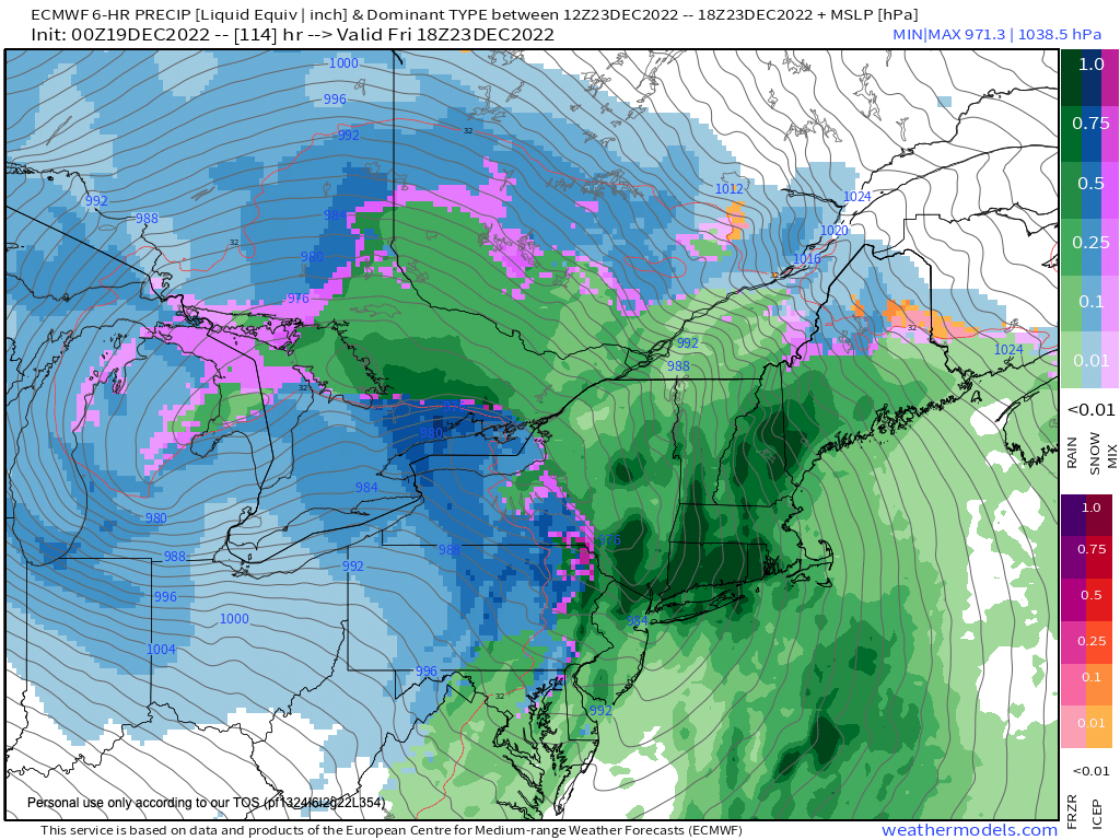
By Thursday, a major storm system will be cranking up on the foot of a major Arctic cold blast into the country.
The core of the cold is diving more southerly into the U.S. rather than southeasterly, which is why a storm is going to develop well west of us along the easterly edge of that cold outbreak.
Clouds will increase in the greater WMass region, and highs will reach the 35-40º range.
Given antecedent cold air at the surface, we may see snow and sleet showers break out across the western highlands west of the I-91 in CT, MA, VT and eastern NY, but with a powerful southerly siphon being drawn up the east coast, we will all turn to rain as milder floods the region, and winds will pick up overnight into Friday.
Friday looks like a very windy and very rainy day, and I’m concerned for the potential for scattered to more widespread power outages, if the wind potential verifies.
Highs will climb into the low to mid 50s, and with such a uniform surface to sky air mass, and a low level jet streak blowing up to 80mph half a mile up, we could see wind gusts of 40-60mph in our region, which would not only prompt Wind Advisories or High Wind Watches to be hoisted, but could result in some wind damage and outages.
By Friday night, Arctic air rushes in behind this system which will deliver a blizzard to areas near or in the Great Lakes region.
This means we may flip back to snow briefly before ending at night with lows crashing into the teens with a flash freeze possible, and a potential hilltown headache mess with all that snowpack melting and then refreezing! That’s a 40 degree temperature drop in 12-18 hours.
Christmas Weekend looks like the coldest of our soon-to-be nascent Winter with highs in the 20s and lows in the low 10s along with blustery conditions, accompanied by partly to mostly sunny skies.
Have a great day, and if you missed the order deadline I still have my 2023 weather calendars with WMass photos at the link below: I won’t be doing one next year, so get ’em while you can!
Follow me on Twitter while it’s still a thing.
AND REMEMBER…
“Hello babies. Welcome to Earth. It’s hot in the summer and cold in the winter. It’s round and wet and crowded. On the outside, babies, you’ve got a hundred years here. There’s only one rule that I know of, babies: Goddamn it, you’ve got to be kind.”
–Kurt Vonnegut