
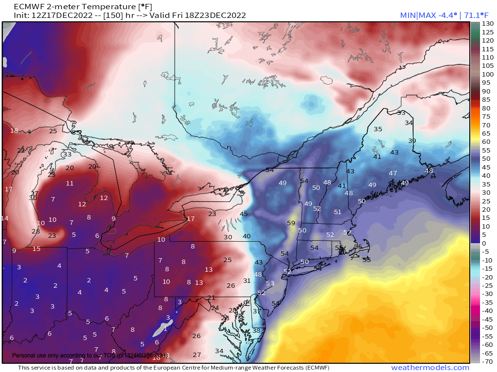
Arctic temps for XMas Day
——————————-
WEEKLY WEATHER NUTSHELL
I hope you had good dreams last night and not wackadoodle ones like I had, wow! I must have eaten too much potato leek soup yesterday, less leeks next time! Just kidding, I love leeks… more leeks next time!
As for our weather nutshell, we’ve got a mixed sky day with clouds increasing and a few snow or rain showers possible later this afternoon and evening with some coatings possible in northwest MA and SVT into Monday morning to be followed by fair but blustery conditions at times, a sweet and sunny Wednesday, a windswept rainy and mild Thursday night into Friday and an Arctic blast for Christmas, but before we dive into all of the weather details below, let’s check a note from our new local weekend sponsor, #CranberryHillHealingArts located in Amherst, MA.
——————–
A NOTE FROM OUR WEEKEND SPONSOR:
DHTWN is sponsored by members, patrons, and Cranberry Hill Healing Arts. The turning of the seasons can be challenging, and Carolyn Walker of Cranberry Hill Healing Arts in Amherst is there for you. When you are searching for ways to be at peace, seek relaxation, and feel more energetic, let Reiki & Sound Healing guide you on your journey to wholeness. Through energy work and the gentle vibrations of singing bowls, chimes, and chanting, Carolyn crafts a safe and calming space to experience renewal. Learn more and/or book your session today by visiting her website.
——————————————-
***DHTWN DAILY WEATHER REPORT***
——————————————-
Good morning everybody, today’s report is also going to be brought to you by The Bulletization Mobile(TM), the finest purveyor of double–dash detailed weather information proliferation since 2011.
TBM has been known to jumpstart Dave’s brain with a combination of morning beeps, honks, scronks, hollers, yells, and ahhhh-OOOOOOO-gahs for over a decade, and is a proud supporter of Dave’s brand of weather nutcakery and artisinal wackiness, and seeks to curb his propensity for run-on sentences (good luck with that).
TODAY’S NUTSHELL
–For today, we’ve got an upper level feature that will run west to east through the region
–This will end up producing more clouds than sunshine through the day
–Highs will reach the low to mid 30s, with west winds gusting up to 20mph at times, putting a slight chill to the air
–By late afternoon and especially tonight, some light snow showers or flurries (or a few rain drops if in southern/eastern areas) will develop
–Should this energy tie with some long-tracking lake effect snow showers, the northern Taconics, Berkshires, NW hilltowns and SVT could see some coatings to maybe an inch or two of fluffy snow by Monday morning
–Lows tonight will bottom out in the low to mid 20s
–For Monday, any morning snow showers or flurries abate, and with a coastal low east and high pressure southwest, we’ll continue west to northwest winds gusting to 25mph at times
–Highs will be in the 30s tomorrow under partly partly sunny skies, and with lows in the upper teens to low 20s
–Tuesday looks like wind starts to slacken with mostly sunny skies and highs in the low to mid 30s and colder lows in the low to mid teens under clear skies as winds die down and radiational cooling perfects itself
–Wednesday is the new Tuesday this week, with similar conditions
–Thursday will see clouds building as a ripping storm system tears into the Midwest with a blizzard for someone in that region, but not for New England the way it looks now
–This storm will pass WELL west of us, and introduce very strong southerly flow on its east side
–Thursday highs will be in the mid 30s to low 40s, and then rain moves in Thursday night, but may start as snow and ice in the high terrain of CT, MA and VT west of the I-91 corridor
–Friday looks very windy and very rainy with gusts up to 50mph possible as highs soar to near or above 50º
–This could cause ponding of road ways in high elevation areas where heavy snow pack exists currently
–Much colder air advects into the region Friday night into Saturday with lows in the teens and highs only in the 20s next weekend for Christmas!
–At least the weather shouldn’t hamper travel Christmas Eve and Day
Have a great day, and if you missed the order deadline, I still have 2023 weather calendars at the link below, and since I won’t be doing one next year, get ’em while you can!
You can also follow me on Twitter.
AND REMEMBER…
“Hello babies. Welcome to Earth. It’s hot in the summer and cold in the winter. It’s round and wet and crowded. On the outside, babies, you’ve got a hundred years here. There’s only one rule that I know of, babies: Goddamn it, you’ve got to be kind.”
–Kurt Vonnegut