[6:45AM, TUES. 12/17/24] PATCHY FOG BURNS OFF W/ MILD DAY AHEAD AFTER A WET NIGHT… BREEZY OUT OF THE SOUTHWEST… PLEASANT WEDNESDAY MORNING WITH RAIN AND SNOW MOVING IN BY EVENING AND OVERNIGHT… ACCUMULATING WET SNOW FAR NORTHWEST MA, SOUTHERN VT AND SOUTHWEST NH PROBABLE… FAST-MOVING FLOW BRINGS COOLER/DRIER THURS & FRIDAY, WITH LOW POTENTIAL FOR SNOW FRIDAY NIGHT EAST OF I-91… ARCTIC HAMMER DROPS THIS WEEKEND, DRY… I ONLY HAVE 2 DOZEN OF MY FINAL-EDITION 2025 WEATHER CALENDARS LEFT… MESSAGE ME IF YOU’D LIKE ONE… MY COZY HOODIES, SHIRT AND HATS SALE ENDS NEXT SUNDAY (DELIVERY FIRST WEEK IN JAN, ORDER BELOW)….

Dave Hayes The Weather Nut Merch / Apparel (ends 12/22)
~~~~~~~~~~~~~~~~~~~~~~
TABLE OF CONTENTS
* Daily Celestials (Sun/Moon Data)
* Sponsor Note
* Morning Discussion
* TIP: Scroll below for sections, or read all
~~~~~~~~~~~~~~~~~~~~~~
YOUR DAILY CELESTIALS
~~~~~~~~~~~~~~~~~~~~~~
STAR:
–OUR STAR WILL RISE AT: 7:13am this morning
–OUR STAR WILL SET AT: 4:20pm this evening
–TOTAL DAYLIGHT TIME: 9 hours and 7 minutes
MOON:
–OUR MOON WILL SET AT: 9:36am this morning
–MOON SET DIRECTION: Northwest
–OUR MOON WILL RISE AT: 6:38pm tonight
–MOON RISE DIRECTION: Northeast
–MOON PHASE: Waning Gibbous (94.4%)
~~~~~~~~~~~~~~~~~~~~~~
A NOTE FROM OUR SPONSOR
~~~~~~~~~~~~~~~~~~~~~~
Dave Hayes The Weather Nut is Sponsored by Individual Community Members, Patrons, and Tandem Bagel Company… No matter the weather, Tandem Bagel is always there for you at several valley locations to make your mornings brighter! With *New Pizza Bagels(!)*, along with bagels baked fresh daily (including Gluten-Free options), house-whipped cream cheese, coffee, and tons of lunch options, Tandem is the perfect quick stop for lunch, breakfast, or a coffee and bagel to go.
You can either 1) visit them in Easthampton, Northampton, Hadley, Florence, and/or West Springfield, 2) hire them to cater your next event, or 3) use their super-streamlined online ordering tool by visiting their website and clicking the “Catering” or “Order Online” links.
~~~~~~~~~~~~~~~~~~~~~~
YOUR MORNING DISCUSSION
~~~~~~~~~~~~~~~~~~~~~~
Good morning folks, we received about a quarter to half an inch of rainfall overnight, and the last batch of showers is tracking northeast through the WMass region early this morning before dawn.
You’ll notice the patchy fog and mild temps in the 40s, and while the fog will burn off as this system lifts east and away from here, the temps will continue to soar up into the upper 40s to mid/upper 50s for a day behind it, with sunshine developing.
Enjoy the mild day!
Below zero temps are possible by Sunday morning!
Woo hoo!
#NOT
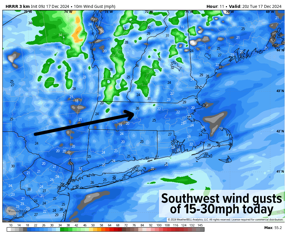
It will also be breezy behind our warm front (and has been in the pre-dawn with gusts up to 35mph or so), so we can expect southwesterlies gusting 15-30mph at times today – a sort of balmy-ish afternoon.
For tonight, lows will dip into the upper 20s to low 30s with patchy fog possible under partly cloudy skies.
Wednesday will start off as a fair, partly to mostly sunny day, but yet another fast-moving zonal storm system will track east-northeast out of the Ohio Valley and likely pass just south of the greater WMass region Wednesday late afternoon and night, and be gone by Thursday morning.
This nighttime impact will help to develop high-terrain accumulating snowfall, as high as 2-4” or so in northeast Berkshire County, western Franklin County and southern VT, with a coating to 2” elsewhere in the central and northern Berkshires, the western hilltowns, far northern Worcester County, eastern Franklin County highlands, and southwest NH, and just a cold steady rain in the Pioneer Valley and lower terrain of WMass, CMass and northern CT.
Lows will be in the low to mid 30s Wednesday night.
By Thursday, sunshine will be developing again, but colder air will be dragged into the region behind the Wednesday night system, as highs should only reach the mid 30s to mid 40s on Thursday with lows in the upper teens to mid 20s.
By Friday, even colder air is seeping into the region, and this cold creeping seep of Arctic air will continue all the way through Monday.
As we end the week, I will be watching a coastal storm that at this point looks to mostly pass out to sea, but IF it were to somehow slow down a bit and become more amplified (which is rather doubtful at the moment), this could become a widespread snowfall, and potentially a major snowstorm east of I-91, so I will keep you updated.
For now, we end the week with partly sunny skies and highs in the upper 20s to mid 30s with some snow showers possible late in the day and in the evening, with lows in the teens.
Whether that system impacts us or stays east, it is going to completely pull through a deep blast of Arctic air for the weekend into Monday with very unseasonably cold temperatures.
Fair weather looks likely through this period, but highs Saturday will be in the mid 20s to low 30s with lows in the single digits above AND below zero possible.
Sunday highs should only reach the teens to maybe low 20s if we’re lucky with icy cold lows again in the single digits, and Monday looks quite cold, too, so get ready to bundle up, my friends, cold is coming!
I hope you have a great day and if you want to combat the cold this Winter with my warm and cozy hoodies or long sleeves, just click below to browse & order:
Dave Hayes The Weather Nut Merch / Apparel (ends 12/22)
“Follow your bliss and the universe will open doors for you where there were only walls.”
― Joseph Campbell
