>>> YOUR DAILY CELESTIALS <<<
STAR:
–OUR STAR ROSE AT: 7:12am this morning
–OUR STAR WILL SET AT: 4:19pm this evening
–TOTAL DAYLIGHT TIME: 9 hours and 7 minutes
MOON:
–OUR MOON WILL SET AT:9:42pm tonight
–MOON SET DIRECTION: West-Southwest
–OUR MOON WILL RISE AT: 11:39am tomorrow morning
–MOON RISE DIRECTION: East-Southeast
–MOON PHASE: Waxing Crescent (25.6%)
~~~~~~~~~~~~~~~~~~~~~~
>>> DAVE’S WEEKLY WEATHER NUTSHELL <<<
–Overcast skies have developed
–Highs will climb into the mid 40s to low 50s
–A few showers are possible in the high terrain before early afternoon
–Otherwise, scattered rain showers develop 2-5pm
–Showers become more numerous and heavier before midnight
–Rain becomes steady and moderate to heavy after midnight
–South and southeast winds will pick up after midnight as well
–Lows will be in the 40s
–Monday morning is the burnt of the storm from midnight to mid-day with heavy rain and gusts of 30-50mph at times
–Some areas south of the Pike, or high terrain areas in WMass/CMass, may gust up to 60mph in isolated spots
–Some power outages are possible, as is street or river flooding with 2-4″ of rain expected
–Very mild highs in the 55-60º range
–Rain won’t entirely quit until either side of Monday’s sunset
–Colder air moves in behind the storm’s cold front with lows in the mid 30s
–Upper pool of cold air moves overhead Tuesday with snow or mixed rain/snow showers possible in the day, highs 35-40º, lows into the low to mid 20s
–Wednesday through Saturday will feature cold high pressure with partly to mostly sunny skies and highs in the mid 30s to low 40s and lows in the 20s, but before we get into the details let’s check a note from our local weekend sponsor, #GerardGhazeyBatesPC, an estate planning law firm in Northampton, MA.
~~~~~~~~~~~~~~~~~~~~~~
>>> A NOTE FROM OUR SPONSOR <<<
Dave Hayes The Weather Nut is Sponsored by Individual Community Members, Patrons & Gerard, Ghazey & Bates, P.C. GGBPC is a Northampton-based law firm regarded as the voice of pragmatic and well-reasoned estate planning, elder law and tax guidance in Western Massachusetts. The firm specializes in estate planning law, and expertly handles other matters such as Elder Law, Tax Law, as well as Real Estate purchase, sales, and refinance transactions. Contact GGBPC today to see how they can help!
>>> MORNING DISCUSSION <<<
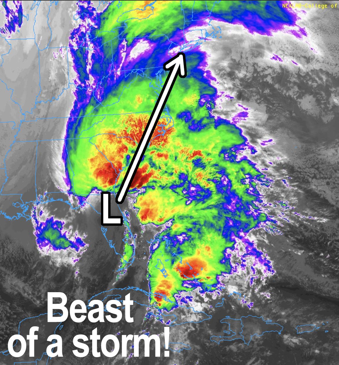
Good morning everybody, we have a major rainy nor’easter on the way set to drop 2-4″ of rain across the region (possibly over 4″, especially in some western hilltown slopes that face east), along with southerly and southeasterly wind gusts of 30-50mph, with potential for a few areas south of the Pike and/or at elevation in WMass or CMass to reach 60mph in a few spots.
Saturated soils combined with high southeasterly winds can loosen the ground and help topple trees, so some isolated power outages are expected by Monday afternoon.
For today, highs will reach the mid 40s to low 50s under overcast skies with a few showers possible, or drizzle, this morning into early afternoon. After that, our first scattered showers should be developing between 2-5pm as moisture and easterly flow increases. The high terrain is the most logical regions to first see some showers in this setup.
Once we get to dinner time and into the night, showers will increase in number and intensity with lows only in the 40s.
Once we get past midnight, steadier and heavier rain will overspread the region, and wind will pick up as well.
Monday morning is the peak of the storm with heavy rain and strong gusty winds, and this strong southerly surge will produce high temps for a day into the 55-60º range.
As our giant negatively-tilted upper low just west of us guides our bombing-out surface low center north-northeast through southern New England, a final burst of rain should move through around dinner time, and then we’ll see the dry slot on the underside of the storm (its southern and southwesterly flanks) push through the region, cutting off rainfall, and allowing a cold front to swing through Monday night.
Lows will drop into the 30s Monday night, and on Tuesday an upper level cold pool of air will float through the region, and as such touch off some scattered snow and/or rain showers with highs only in the mid to upper 30s under partly sunny skies. Lows will be in the low 20s.
Thereafter, a large area of high pressure will be tracking east toward the east coast of the U.S. which will produce a large area of developing fair weather in the wake of our potent rainy Miller A nor’easter.
Highs should generally climb into the mid 30s to low 40s for the Wednesday through Saturday period with lows in the 20s, under partly to mostly sunny skies.
Beyond that, Christmas Eve and Christmas Day look a bit milder with continues dry conditions at the moment.
Have a great day and I will update you again this evening regarding our incoming major storm!
>>> BE KIND <<<
“Hello babies. Welcome to Earth. It’s hot in the summer and cold in the winter. It’s round and wet and crowded. On the outside, babies, you’ve got a hundred years here. There’s only one rule that I know of, babies: Goddamn it, you’ve got to be kind.”
–Kurt Vonnegut
