Dave Hayes The Weather Nut Merch / Apparel (ends 12/22)
~~~~~~~~~~~~~~~~~~~~~~
TABLE OF CONTENTS
* Daily Celestials (Sun/Moon Data)
* Sponsor Note
* Morning Discussion
* TIP: Scroll below for sections, or read all
~~~~~~~~~~~~~~~~~~~~~~
YOUR DAILY CELESTIALS
~~~~~~~~~~~~~~~~~~~~~~
STAR:
–OUR STAR ROSE AT: 7:12am this morning
–OUR STAR WILL SET AT: 4:19pm this evening
–TOTAL DAYLIGHT TIME: 9 hours and 7 minutes
MOON:
–OUR MOON WILL SET AT: 8:49am tomorrow morning
–MOON SET DIRECTION: Northwest
–OUR MOON WILL RISE AT: 5:26pm this evening
–MOON RISE DIRECTION: Northeast
–MOON PHASE: Waning Gibbous (98.2%)
~~~~~~~~~~~~~~~~~~~~~~
A NOTE FROM OUR SPONSOR
~~~~~~~~~~~~~~~~~~~~~~
Dave Hayes The Weather Nut is Sponsored by Individual Community Members, Patrons, and Tandem Bagel Company… No matter the weather, Tandem Bagel is always there for you at several valley locations to make your mornings brighter! With *New Pizza Bagels(!)*, along with bagels baked fresh daily (including Gluten-Free options), house-whipped cream cheese, coffee, and tons of lunch options, Tandem is the perfect quick stop for lunch, breakfast, or a coffee and bagel to go.
You can either 1) visit them in Easthampton, Northampton, Hadley, Florence, and/or West Springfield, 2) hire them to cater your next event, or 3) use their super-streamlined online ordering tool by visiting their website and clicking the “Catering” or “Order Online” links.
~~~~~~~~~~~~~~~~~~~~~~
YOUR MORNING DISCUSSION
~~~~~~~~~~~~~~~~~~~~~~
Good morning folks, I’ve seen many reports of a coating to 1” of snow, but given that we had colder air aloft dig a bit further south, combined with the precip shield being a bit more robust, there are number of 1-2” reports in northern CT and far southern WMass… let me know how much you got!
Icing has been developing in southern CT and now pushing up into parts of Hartford County CT and nearby areas, so let me know what you are seeing this morning.
The bottom line is that this system is pulling away, but I can’t rule out some freezing drizzle early to mid-morning in northern CT or southern MA, but I think it’s too cold for anything but a few spitting snow showers north of the Pike before this thing ends.
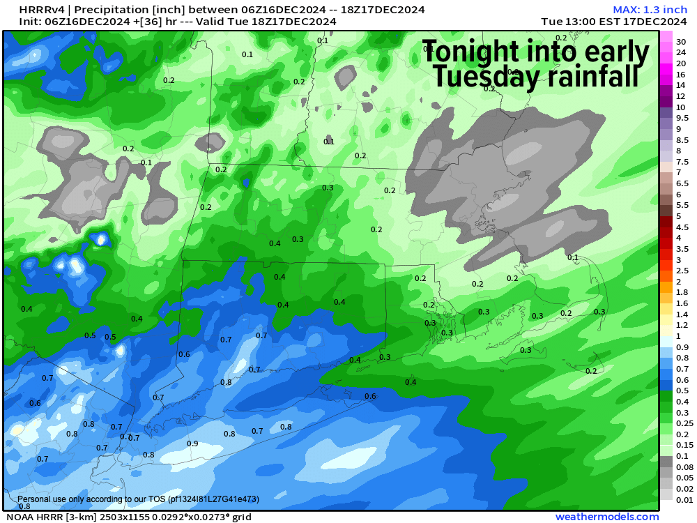
Temps will come up today as it pulls away with highs in the 35-40º range under mostly cloudy skies with a few sunny breaks possible in the afternoon before clouds thicken right back up towards sunset with a period of scattered showers pushing in from the southwest about 5pm towards midnight when the steadier and heavier rainfall arrives.
If you live in northern MA north of the Rt. 2 coriddor into southwest NH there could be some freezing rain showers in colder valleys before it all flips to rain, so be alert to that potential.
Lows tonight will essentially match the highs today, and patchy fog will be possible. We’ll all see about a third to half an inch of rain overnight, and it should be mostly gone by dawn tomorrow.
Tuesday will see temps spike into the 40s to mid 50s for a day under partly to mostly sunny skies, so of course any snow on the ground this morning (given the combo of incoming rain and mild temps) will soon enough go buh-bye!
Cooler air will slowly filter into the region Tuesday night through Thursday night with another zonal-tracking (west to east tracking) disturbance moving through our flow.
After a seasonably cold night Tuesday night in the upper 20s to low 30s, we’ll kick off the mid-week period with a fair-weather day with highs in the upper 30s to mid 40s which is about seasonable for mid-December.
Clouds will increase in the evening as another system sets up to track just south of our region, though the exact latitude is unclear still. This looks to bring some wet accumulating snow to the Berkshires, northwest hilltowns of WMass, and southern VT into southwest NH with rain/snow mix elsewhere, trending to rain by Thursday morning.
Thursday looks cooler, with highs in the 30s to low 40s, but colder air will be on the move for Friday and especially over the weekend when an Arctic blast delivers VERY cold air into our region ahead of the Christmas holiday.
As a famous winter weather forecaster and great meteorologist Bernie Rayno out of PA likes to remind us, you have to watch when cold is arriving or leaving a region for winter storm potential and mischief.
Friday night into Saturday is such a period, and I will certainly keep you updated as the Arctic hammer gets set to deliver the cold into the greater WMass region once again.
I hope you have a great day and if you want one some cozy hoodies or shirts, just click below to order:
Dave Hayes The Weather Nut Merch / Apparel (ends 12/22)
“Follow your bliss and the universe will open doors for you where there were only walls.”
― Joseph Campbell
