
My 9th Edition, 2023 Weather Wall Calendars have shipped, but you can order them here if you are a later-shopper.
——————————-
DAVE’S WEEKLY WEATHER NUTSHELL
–Highly elevation-dependent major western hilltown and Berkshire snow storm is here, but impacts restricted to the highest terrain
–Rain and snow will continue today in varying intensities, raw day ahead
–Easterly wind gusts will blow 20-35mph at times, especially at elevation, less in the valley
–Moderate to major snow accumulations in the high terrain expected, less so in eastern Franklin and northern Worcester County, as well as the southern Berkshires into northern Litchfield County CT
–Cold air moves in tonight and flips most of us back to snow with additional light accumulations possible
–Snow showers Saturday morning relent and lead to a multi-day period of cold but fair weather through Wednesday
–Late week winter storm still possible before Christmas
Now then, before we jump into the weather discussion/details below, let’s check a note from our local and delicious sponsor, #TandemBagelCo, with their newest location in West Springfield, MA.
——————–
A NOTE FROM OUR SPONSOR:
DHTWN Is Sponsored by Members, Patrons & Tandem Bagel Company: No matter the weather, Tandem Bagel is always there for you at several valley locations to make your mornings brighter! With bagels baked fresh daily (including Gluten-Free options), house-whipped cream cheese, coffee, and tons of lunch options, Tandem is the perfect quick stop for lunch, breakfast, or a coffee and bagel to go. Find them in Easthampton, Northampton, Hadley, Florence, and West Springfield, or use their super-streamlined online ordering tool by visiting their website.
——————————————-
***DHTWN DAILY WEATHER REPORT***
——————————————-
NWS ALERTS
1. Winter Weather Advisories are up for central and eastern Franklin County into northern Worcester County MA
2. Winter Storm Warnings continue for the western hilltowns of WMass (western Hampden, Hampshire and Franklin) along with the Berkshires, all of southern VT, southwest NH and northern Litchfield County
DHTWN REMINDER
–The odds of being a human is 1 in 400,000 billion… make it count, even in a small way (see Kurt Vonnegut quote at end of post)
DAILY CELESTIAL (STAR):
–OUR STAR ROSE AT: 7:12am this morning
–OUR STAR WILL SET AT: 4:19pm this evening
–TOTAL DAYLIGHT TIME: 9 hours and 7 minutes
NIGHTLY CELESTIAL (MOON):
–OUR MOON WILL SET AT: 12:23pm this afternoon
–OUR MOON WILL RISE AT: 12:27am tomorrow morning
–MOON SET DIRECTION: West
–MOON RISE DIRECTION: East
–MOON PHASE: Waning Crescent (48.9%)
———————-
DAILY TERRESTRIAL (ZoneCast)
ZONE 1 (Northern Region)
Southern VT, Southwest NH, N. Taconics NY
–High Temps: Low to Mid 30s
–Low Temps: Upper 20s to Low 30s
–Wind: Easterly gusts up to 20-35mph
–Skies: Cloudy
–Precipitation: Periods of snow, heavy at times into tonight, some valley areas may mix with rain at times
ZONE 2 (Central Region)
WMass, N. CMass, N. Litchfield County, C./S. Taconics NY
–High Temps: Mid to Upper 30s
–Low Temps: Upper 20s to Mid 30s
–Wind: Easterly gusts up to 20-35mph
–Skies: Cloudy
–Precipitation: Periods of snow in the high elevations above 1000 feet, heavy at times into tonight, with rain or rain/snow mix in lower elevations, turning back to snow late tonight
ZONE 3 (Southern Region)
S. CMass, S. Litchfield County, NC.CT, & NE.CT
–High Temps: Upper 30s to Low 40s
–Low Temps: Low to Mid 30s
–Wind: Easterly gusts up to 20-35mph
–Skies: Cloudy
–Precipitation: Rain, heavy at times, some snow may mix in, and NW Hartford County may see light wet snow accumulations of 2-4″
———————-
WHERE’S DAVE?
–*I’ve been reporting our weather daily here and at https://www.westernmassweather.com for almost 10 years*
–Please visit my this FB page via the app or web like selecting a channel you want to tune into if I’m not auto-kissing your screens
–I’m always here daily, so keep stopping by!
———————-
MORNING DISCUSSION
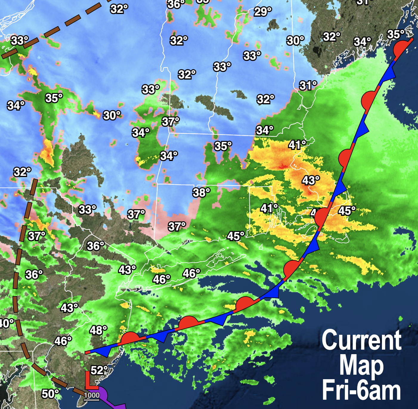
Good morning everybody, our storm is underway with low pressure hugging the Delaware coastline and set to track to near Block Island later today.
This provides easterly flow into the region at low levels, hence most of us are seeing rainfall this morning with high elevation snow falling, and mixed precip in between.
Easterly gusts will blow 20-35mph today, and based on observations this morning, I think outages will be less of a concern, but should be scattered in northeast Berkshire County, the northwest hilltowns, and in parts of the southern Green Mountains of VT. Highs reach the mid to upper 30s today.
Rain and snow will fall, at times moderate to heavily, and flip back to all snow for most later tonight as the storm pulls away, with additional accumulations possible. The storm ends as a few snow showers Saturday morning, then pulls away.
MORNING OBSERVATIONS/ADJUSTMENTS
The main observations of note this morning are that temps are above freezing in the lower elevations, even in the Housatonic River Valley of the southern Berkshires down into parts of northern LItchfield County and the Walloomasac River Valley area of southwest VT near Bennington, as well as southwest Hampshire County. Even portions of northwest Hampden County nearest the valley floor are milder, and those areas are mainly raining this morning or rain/snow mix, with rain in much of the CT River Valley as expected, and snow in the high terrain mainly above 1000 feet in eastern Franklin County, northern Worcester County and of course the high terrain in MA and VT west of I-91.
Another observation is that the precipitation shield is more showery and less solid than was expected, and without longer-term bands of heavier precipitation, it’s hard to take advantage of dynamic cooling to produce more snow in the elevations below 1000 feet in these marginal-temperature events (meaning when temps are at or just above freezing).
The thinking was that the heavier precipitation would fall this morning, and while periods of moderate to sometimes heavy rain and snow will fall, it doesn’t look to be as sustained, and it may take until tonight’s switch back to snow before the storm ends by dawn on Saturday to achieve snow ranges offered yesterday, if they do.
Given all this, I am going to revise and lower some snow amounts based on what we’re seeing this morning, please see below.
REGIONAL SNOW AMOUNTS
10-18″, isolated up to 24″
(All/mostly snow)
–Northeastern Berkshire County
–Northwestern hilltowns (northwestern Hampshire / western Franklin)
–Eastern Bennington / western Windham VT (southern Greens)
6-12″
(Mostly snow, Friday period of mixed rain at times)
–Southeastern Berkshire County
–Northwestern Berkshire County from Pittsfield north to North Adams (some valley areas may see less than 5″)
–Northwestern Bennington County, northeastern Windham County VT
–Southwest NH (though some 12″+ amounts in northern Cheshire are possible, and some sub-6″ amounts south and west of Keene)
–Southwestern hilltowns (southwestern Hampshire / Hampden)
2-6″
(Snow mixes with or changes to rain)
–Southwestern Berkshire County (some high terrain areas south of Pittsfield see 6″+)
–Southwestern Bennington County
–Southeastern Windham County
–Northern Litchfield County
–Central and eastern Franklin County
–Pelham Hills in Pelham, MA
–Northern Worcester County (some 6″+ amounts there)
Slushy coatings up to an inch or two
(Mostly rain, some snow on back end tonight)
–Pioneer Valley from Greenfield points southeast and south
–Southern CMass
–North-central and northeast CT
–Eastern Hampden County
Please post your current reports below with any pics, please!
Have a great day and I will update around mid-day.
Also, if you missed the order deadline I still have my 2023 weather calendars with WMass photos at the link below: I won’t be doing one next year, so get ’em while you can!
Follow me on Twitter while it’s still a thing.
AND REMEMBER…
“Hello babies. Welcome to Earth. It’s hot in the summer and cold in the winter. It’s round and wet and crowded. On the outside, babies, you’ve got a hundred years here. There’s only one rule that I know of, babies: Goddamn it, you’ve got to be kind.”
–Kurt Vonnegut