
TABLE OF CONTENTS
* Daily Celestials (Sun/Moon Data)
* Weekly Weather Nutshell
* Morning Discussion
* TIP: Scroll below for sections, or read all
~~~~~~~~~~~~~~~~~~~~~~
YOUR DAILY CELESTIALS
~~~~~~~~~~~~~~~~~~~~~~
STAR:
–OUR STAR ROSE AT: 7:1]1am this morning
–OUR STAR WILL SET AT: 4:19pm this evening
–TOTAL DAYLIGHT TIME: 9 hours and 8 minutes
MOON:
–OUR MOON WILL SET AT: 7:05pm this evening
–MOON SET DIRECTION: West-Southwest
–OUR MOON WILL RISE AT: 10:42am tomorrow morning
–MOON RISE DIRECTION: East-Southeast
–MOON PHASE: Waxing Crescent (8.4%)
~~~~~~~~~~~~~~~~~~~~~~
A NOTE FROM OUR SPONSOR
~~~~~~~~~~~~~~~~~~~~~~
Dave Hayes The Weather Nut is Sponsored by Individual Community Members, Patrons, and Tandem Bagel Company… No matter the weather, Tandem Bagel is always there for you at several valley locations to make your mornings brighter! With bagels baked fresh daily (including Gluten-Free options), house-whipped cream cheese, coffee, and tons of lunch options, Tandem is the perfect quick stop for lunch, breakfast, or a coffee and bagel to go. Find them in Easthampton, Northampton, Hadley, Florence, and West Springfield, or use their super-streamlined online ordering tool by visiting their website.
~~~~~~~~~~~~~~~~~~~~~~
YOUR WEEKLY WEATHER NUTSHELL
~~~~~~~~~~~~~~~~~~~~~~
–The weather will do stuff, the end, I’m kidding!
–Weather is as weather does, talk to you tomorrow, I’m a jokester!
–All (poor) attempts at humor aside, after a cold start in the 20s and low 30s we’ll have the nicest weather day today for many days to come, so get out and enjoy it
–High pressure tracks east and winds will kick up out of the west in gusts of 20-30mph today under sunny skies
–Milder air works in, and highs will rise into the mid 40s to low 50s, so like I said, get thee bods outside and soak it up!
–Breezy conditions continue tonight with lows in the low to mid 30s
–Saturday looks like a partly sunny day on average, and a bit cooler with highs in the mid 40s as a back door cold front emanating from northern Maine tries to cool us down
–Lows Saturday night will dip to near freezing
–Clouds will increase on Sunday, becoming overcast, as a deepening storm runs north up the eastern seaboard
–Some scattered showers are possible during the daylight hours on Sunday, highs will reach the mid to upper 40s with an east wind developing
–Wind and rain picks up Sunday night with lows in the 40s
–Wind and rain, heavy at times continue on Monday with highs well into the 50s as our storm runs into the northeast U.S.
–Rain abates Monday night with lows in the upper 20s to low 30s
–A second weaker storm could bring light snow to parts of our region, or mixed snow and rain showers, so stay tuned for updates on that
–Colder and fair weather arrives by mid to late next week
~~~~~~~~~~~~~~~~~~~~~~
YOUR MORNING DISCUSSION
~~~~~~~~~~~~~~~~~~~~~~
Good morning everybody, the Cosmos will appear blue today, and our star will spread its bright rays widely into the vast void, and we’ll catch a comparatively small number of them, and this shall be something towards which we can express our gratitude.
We got to be born, and experience this crazy world, and have (hopefully) some good moments mixed into this life, and despite all the messages that we’re not good enough, we’re not doing it right, or that we need this or that to be happy, we can choose to foster Gratitude for the simplest things like being able to see, or hear, or walk if we can, or eat a nice bite of food, or laugh with a friend, and if we pull up from our daily grind, that is really a very good piece of fortune we can experience in the littlest moments.
As far as our weather is concerned, it’s fairly tranquil today and tomorrow, though the wind will kick up today and be gusty at times out of the west at 20-30mph as we squeeze between high pressure areas.
The high pressure to our south (which will exit the east coast this weekend and make way for our developing coastal storm down by FL and GA to run up the coast and slam some rain and wind into New England Sunday night into Monday) will be responsible for warming up our temps into the mid 40s to low 50s for highs under sunny skies today, so enjoy it! Or complain about it, I suppose, do what you want, but I’m going to enjoy it!
Lows tonight will be in the low to mid 30s and breezes will continue, for at least the first part of the night.
Saturday is the weekend pick with partly sunny skies and highs in the mid 40s as we await our storm. Lows will be either side of 30º.
Sunday is when we cloud up, become overcast, and will watch our coastal storm really get its act together BEFORE reaching our latitude.
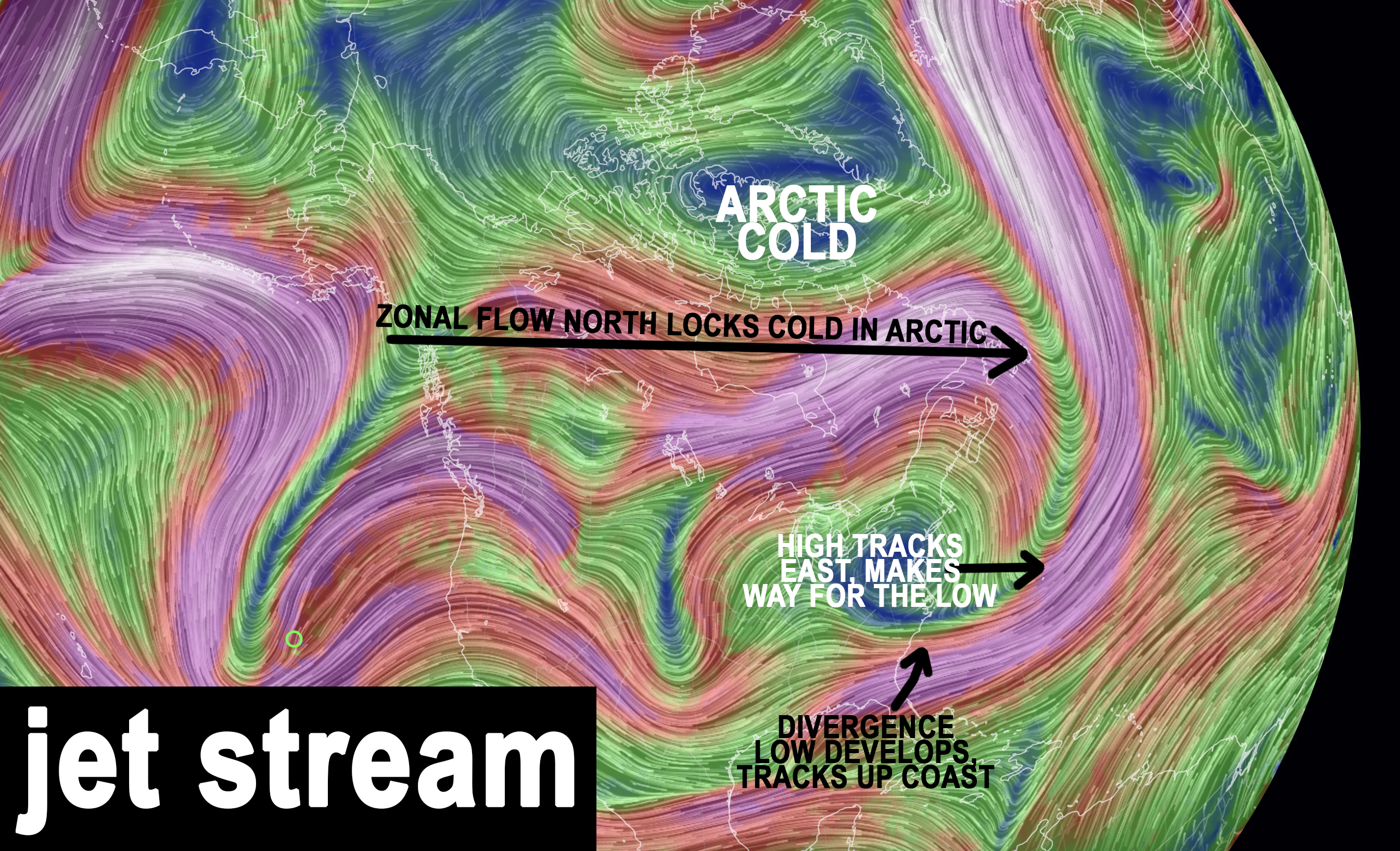
This could bloom into a 970 or 980mb low center, which is LOW pressure, and if it were the middle of winter with cold in place, we might be bandying about the “B” word.
As such, the Arctic air is locked north of us due to zonal flow to our north, so this will be a rain event.
First showers will likely get in here during the day on Sunday as warmer moist air surges northward and overspreads southern New England. Highs will reach the 45-50º range and an east wind will be developing off of the ocean.
Rain will be picking up intensity Sunday night and into Monday, as will wind due to the tighter pressure gradient to our south moving into the region.
Rain will fall heavily at times into Monday, and a solid 1-3″ of rain is expected, and maybe a bit more.
This should occur over a slightly longer period of time, so for now, flooding is not a big concern, but that may change to stay tuned for updates.
It’ll be quite mild on Monday during the height of the storm with highs well into the 50s, but temps will crash late Monday night behind the departed storm, with lows in the upper 20s to low 30s.
By Tuesday, a frontal boundary to our east may help develop a second weaker low, and with colder air in place, that may allow for a light snow event to develop, or an area of mixed rain and snow showers with highs in the 30s.
Thereafter, we get into a fair weather stretch mid to late next week with more sunshine and continued seasonably cold temps.
Have a great day, and stay tuned for updates about our incoming rainy (and potentially windy) Nor’easter!
>>> BE KIND <<<
“Hello babies. Welcome to Earth. It’s hot in the summer and cold in the winter. It’s round and wet and crowded. On the outside, babies, you’ve got a hundred years here. There’s only one rule that I know of, babies: Goddamn it, you’ve got to be kind.”
–Kurt Vonnegut