
My 9th Edition, 2023 Weather Wall Calendars have shipped, but you can order them here if you are a later-shopper.
——————————-
DAVE’S WEEKLY WEATHER NUTSHELL
–Highly elevation-dependent major western hilltown and Berkshire snow storm on the way for Friday into Saturday morning
–Mostly cloudy today, breezy out of the east, cold
–First snow and rain showers arrive after 8 or 9pm tonight
–Snow and rain picks up after midnight, and falls heavily at times Friday, especially Friday afternoon and evening
–Any rain or mix changes back to snow Friday night into Saturday morning with some light accumulations possible
–Heavy wet snow accumulations in the high terrain west of the CT River and throughout much of SVT and SWNH, with lesser amounts in eastern Franklin County and northern Worcester County
–Most high terrain places see 6-12″, but the highest elevations could see 1-2 feet
–BE CAREFUL removing this snow, people have heart attacks by working too hard too fast, take your time, and don’t clear an active snowblower with your hands!!!!!
–Fair and cold weather Sunday through Wednesday
–Another major winter storm possible by Dec. 23rd into Christmas Eve Day
Now then, before we jump into the weather discussion/details below, let’s check a note from our local and delicious sponsor, #TandemBagelCo, with their newest location in West Springfield, MA.
——————–
A NOTE FROM OUR SPONSOR:
DHTWN Is Sponsored by Members, Patrons & Tandem Bagel Company: No matter the weather, Tandem Bagel is always there for you at several valley locations to make your mornings brighter! With bagels baked fresh daily (including Gluten-Free options), house-whipped cream cheese, coffee, and tons of lunch options, Tandem is the perfect quick stop for lunch, breakfast, or a coffee and bagel to go. Find them in Easthampton, Northampton, Hadley, Florence, and West Springfield, or use their super-streamlined online ordering tool by visiting their website.
——————————————-
***DHTWN DAILY WEATHER REPORT***
——————————————-
NWS ALERTS
1. NEW Winter Weather Advisories have been hoisted for central and eastern Franklin County into northern Worcester County MA
2. Winter Storm Watch continues for Cheshire County NH, likely to be converted to a Warning today
3. Winter Storm Warnings have been hoisted for the western hilltowns of WMass (western Hampden, Hampshire and Franklin) along with the Berkshires, all of southern VT and northern Litchfield County
DHTWN REMINDER
–The odds of being a human is 1 in 400,000 billion… make it count, even in a small way (see Kurt Vonnegut quote at end of post)
DAILY CELESTIAL (STAR):
–OUR STAR ROSE AT: 7:11am this morning
–OUR STAR WILL SET AT: 4:19pm this evening
–TOTAL DAYLIGHT TIME: 9 hours and 8 minutes
NIGHTLY CELESTIAL (MOON):
–OUR MOON WILL RISE AT: 11:23pm tonight
–OUR MOON WILL SET AT: 12:23pm tomorrow afternoon
–MOON RISE DIRECTION: East
–MOON SET DIRECTION: West
–MOON PHASE: Waning Gibbous (58.6%)
———————-
DAILY TERRESTRIAL (ZoneCast)
ZONE 1 (Northern Region)
Southern VT, Southwest NH, N. Taconics NY
–High Temps: Mid to Upper 30s
–Low Temps: Upper 20s to Low 30s
–Wind: Easterly gusts up to 25mph
–Skies: Mostly Cloudy
–Precipitation: None today, first snow arrives after 8pm tonight
ZONE 2 (Central Region)
WMass, N. CMass, N. Litchfield County, C./S. Taconics NY
–High Temps: Mid to Upper 30s
–Low Temps: Low to Mid 30s
–Wind: Easterly gusts up to 25mph
–Skies: Mostly Cloudy
–Precipitation: None today, first snow and rain showers arrive after 8pm tonight
ZONE 3 (Southern Region)
S. CMass, S. Litchfield County, NC.CT, & NE.CT
–High Temps: Mid to Upper 30s
–Low Temps: Low to Mid 30s
–Wind: Easterly gusts up to 25mph
–Skies: Mostly Cloudy
–Precipitation: None today, first snow and rain showers arrive after 8pm tonight
———————-
WHERE’S DAVE?
–*I’ve been reporting our weather daily here and at https://www.westernmassweather.com for almost 10 years*
–Please visit my this FB page via the app or web like selecting a channel you want to tune into if I’m not auto-kissing your screens
–I’m always here daily, so keep stopping by!
———————-
MORNING DISCUSSION
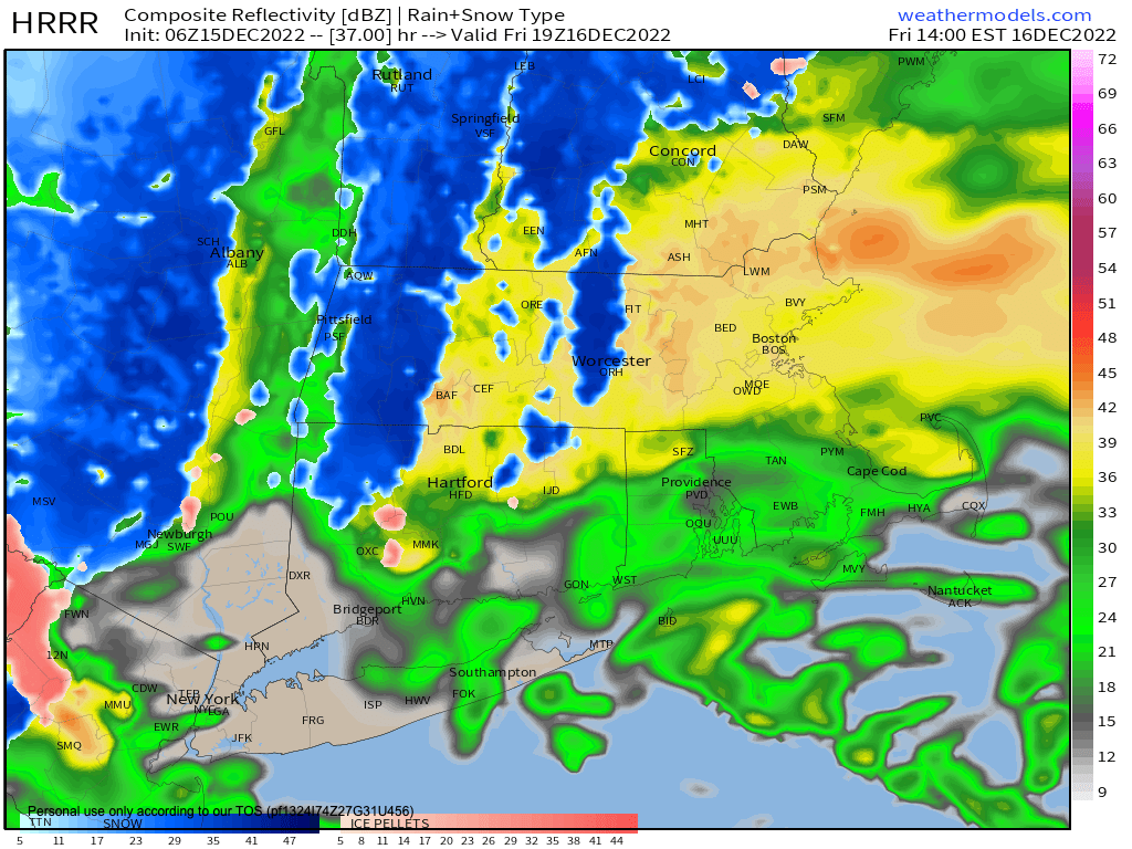
Good morning everybody, we’ve got a juicy winter storm developing to our south near Virginia and it will track northeast off of the New Jersey coast and likely run over Block Island or just south of it into Cape Cod or Cape Cod Bay, destined for the Gulf of Maine.
A strong southeasterly jet streak (i.e. lower level river of faster moving air) will draw copious Atlantic Ocean moisture and hurl it northwestward into the greater WMass region during all of Friday and combine with cold-enough temps in the high elevations above 1000-1500 feet to produce a major heavy wet snowstorm that will jackpot out (yes, I’m using that as a verb) at 1-2 feet of snow in parts of the northern Berkshires, northwestern hilltowns of WMass and southern VT, with lesser amounts in the lower elevations, to little to none in valley locations from Northampton south and east where temps will be just mild enough to support mostly rain, or periods of mixed rain and snow that don’t really accumulate.
SUMMARY
Today starts off mostly cloudy and we’re cold with an easterly breeze – a raw day with highs in the 30s, except maybe hitting 40º in northern CT and maybe staying in the upper 20s in SVT/SWNH.
Clouds thicken today as the storm gets its act together and heads northeast, and first snow and rain showers move in between 8pm-Midnight tonight with lows in the upper 20s to mid 30s from north to south.
Precipitation will become steadier and heavier at times into Friday morning, and heavy snow will develop in the high terrain with mixed rain and snow in the valleys or just plain rain (especially for Hampden County east to Worcester and south through north-central and northeast CT).
Highs Friday will reach the mid to upper 30s, but should hang in the low 30s in northwest MA, the Berkshires, southern VT and southwest NH (and possible in the N. Worcester County border towns with NH).
Snow and rain continues Friday afternoon and evening, heavy at times, and even in the valley when a heavier burst of precip moves through, dynamic cooling processes may flip us to snow for a time with some slush forming, but overall the valley should see lighter precipitation compared to the high terrain which will be getting blasted by upslope flow from the southeast, ringing out heavy snow over the high terrain.
POWER OUTAGES: HEAVY SNOW AND WIND
I am quite concerned for scattered to widespread power outages given that easterly to northeasterly winds will be gusting 25-40mph with heavy wet snow accumulating 6-12″ in many areas above 1000 feet, with up to 1-2 feet in the higher terrain areas of northwest MA and southern VT, so have your “outage stuff” ready, you know the drill if you live in these areas.
I have edited and pasted in parts of last’s evening forecast below as they’re still relevant, including snow amounts etc.
TIMING
As for timing, first snow and rain showers move in between 8pm and midnight I believe, though we can’t rule out some showers before 8pm tomorrow night. The brunt of the storm moves in for early Friday morning through the day and ending sometime at night, with potential for it to linger into Saturday morning.
ELEVATION
As mentioned, this will be a highly elevation-dependent winter storm. Areas above 1000 feet will see the biggest wintry impacts (especially above 1500-2000 feet), and less below with sharp drop-offs in accumulation with more rain involved.
The valley floor should see mostly rain with some snow at the beginning with a cooler night-time arrival, and some at the end as the storm pulls colder into the region.
Valley areas may also see periods where rain mixes with or flips to heavy wet snow during the heaviest precip bands as cold air is drawn down from the aloft, then when it lightens back up, back to rain.
COLD AIR DAMMING
We will have a strong high pressure system well northeast of New England, but some cold air should still be draining into northeast parts of the greater WMass region, notably central and eastern Franklin County and northern Worcester County.
It is these areas where I have the greatest uncertainty for winter impacts, which will be dependent on this cold air damming and the wind direction.
It should be noted that these areas were issued Winter Weather Advisories by the NWS overnight for light to moderate snow accumulations along with periods of rain.
If the wind maintains out of the east, we could see much less snow with lighter accumulations and more rain, but if wind is more east-northeasterly we could see that combine with dynamic cooling to produce a light to moderate snowfall in these areas with some rain at times, hence the Advisories.
BIGGEST WINTER IMPACTS:
NORTHWEST MA & SOUTHERN VT
The northern Litchfield hills, the northwestern high-terrain of Hartford County, and especially. the Berkshires (eastern areas get the most snow), the western hilltowns, southern VT and southwest NH will see the brunt of this major winter system.
REGIONAL SNOW AMOUNTS
Elevations down to 1000 feet in the aforementioned “biggest-impact” areas should end up with 6-10″, with 10-18″ in the highest elevations, and up to 2 feet possible in spots.
Any of those areas below 1000 feet should see more like 3-6″, with very sharp differences in haves and have nots over small geographic distances, and elevational changes.
I am including much of central and eastern Franklin County and northern Worcester County in sub-1000′ elevations in that range including Greenfield (except the valley floor from Whately/Sunderland up to near Greenfield, where coatings up to 2-3″ are possible, which extends from Northampton points east and south in MA and CT.
There will likely be areas from Northampton south and east that see little to nothing and mostly rain.
Lastly, however, we’ll have to see how the Friday night into first half of Saturday period pans out, as we may get some backside precipitation that changes from rain to snow and adds additional light to moderate accumulations by Saturday afternoon.
Have a great day and I will update sometime this afternoon after I’ve had time to digest any/all new information on this developing major elevation snowstorm, and if you missed the order deadline, I still have 2023 weather calendars at the link below: I won’t be doing one next year, so get ’em while you can!
Follow me on Twitter while it’s still a thing.
AND REMEMBER…
“Hello babies. Welcome to Earth. It’s hot in the summer and cold in the winter. It’s round and wet and crowded. On the outside, babies, you’ve got a hundred years here. There’s only one rule that I know of, babies: Goddamn it, you’ve got to be kind.”
–Kurt Vonnegut