
Good evening everybody, we’ll hopefully have a more clear picture by tomorrow morning in terms of trends and forecast coalescence.
TIMING
As for timing, first snow and rain showers move in between 8pm and midnight I believe, though we can’t rule out some showers before 8pm tomorrow night. The brunt of the storm moves in for early Friday morning through the day and ending sometime at night, with potential for it to linger into Saturday morning.
KEY FACTORS FOR IMPACTS/RESULTS
There are so many things going on with this storm that will impact who gets snow and how much that it’s a bit dizzying, but the main issues are as follows:
–Elevation
–Dynamic Cooling
–Storm Track
–Cold Air Damming (Franklin and N. Worcester Counties)
ELEVATION
As mentioned, this will be a highly elevation-dependent winter storm. Areas above 1000 feet will see the biggest wintry impacts (especially above 1500-2000 feet), and less below with sharp drop-offs in accumulation with more rain involved.
The valley floor should see mostly rain with some snow at the beginning with a cooler night-time arrival, and some at the end as the storm pulls colder into the region.
DYNAMIC COOLING
This storm is expected to be a juicy one, and so during the heaviest precipitation bands some areas in the higher terrain could flip from rain to snow where it doesn’t remain all snow for the whole event.
STORM TRACK
One trend I’ve been noting is a slightly colder one with the eventual track of the secondary low that forms along the Mid-Atlantic more likely staying just south of Long Island and running somewhere between Cape Cod Bay and Nantucket.
The further southeast the storm tracks, the more cold it holds in, helping to produce heavier snow totals in the high terrain.
COLD AIR DAMMING
We will have a strong high pressure system well northeast of New England, but some cold air should still be draining into northeast parts of the greater WMass region, notably central and eastern Franklin County and northern Worcester County.
It is these areas where I have the greatest uncertainty for winter impacts, which will be dependent on this cold air damming and the wind direction.
If it maintains out of the east, we could see much less snow with lighter accumulations and more rain, but if wind is more east-northeasterly we could see that combine with dynamic cooling to produce a light to moderate snowfall in these areas with some rain at times.
BIGGEST WINTER IMPACTS:
NORTHWEST MA & SOUTHERN VT
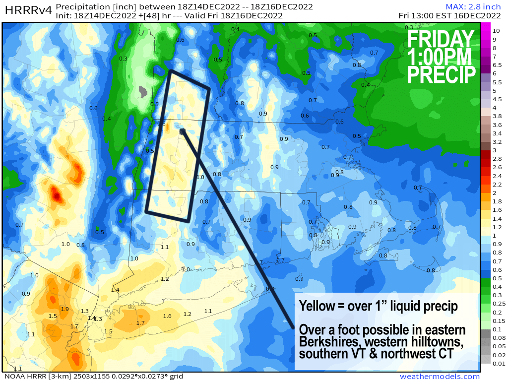
The odds have increased a bit for a major heavy wet snowstorm with some power outages for the northern Litchfield hills, the northwestern high-terrain of Hartford County, and especially. the Berkshires (eastern areas get the most snow), the western hilltowns, southern VT and southwest NH.
REGIONAL SNOW AMOUNTS
Elevations down to 1000 feet in the aforementioned “biggest-impact” areas should end up with 6-10″, with 10-18″ in the highest elevations.
Any of those areas below 1000 feet should see more like 3-6″, with very sharp differences in haves and have nots over small geographic distances, and elevational changes.
I would include much of central and eastern Franklin County and northern Worcester County in sub-1000′ elevations in that range (except the valley floor from Whately/Sunderland up to near Greenfield, where coatings (or nothing) up to 2-3″ are possible, which extends from Northampton points east and south in MA and CT.
Lastly, we’ll have to see how the Friday night into first half of Saturday period pans out, as we may get some backside precipitation that changes from rain to snow and adds additional light to moderate accumulations by Saturday afternoon.
I will update you in the morning, but that’s what I have for this evening, have a great night!
P.S. If you’d like one of my 2023 weather wall calendars or need a holiday gift idea, I have calendars in stock ready to ship at this secure order/info link, thx!
——————————-
My 9th Edition, 2023 Weather Wall Calendars have shipped, but you can order them here if you are a later-shopper.
——————————-
DAVE’S WEEKLY WEATHER NUTSHELL
–Blustery and cold today, north to northwesterly. gusts 25-35mph at times, bundle up, highs 30s
–Mostly clear tonight, cold in the teens
–Clouds increase Thursday, first snow and rain showers between 6-10pm
–Precipitation becomes heavy with ice or rain valley locations and heavy snow developing in the Berkshires overnight into the western hilltowns, northern Litchfields, SVT and SWNH
–Snow and rain Thursday, heavy at times, major snow accumulations possible central and northern Berkshires, western hilltowns of WMass and especially southern VT, lasting into Friday night
–There could be some icing issues along the Rt. 2 corridor from Franklin County east into northern CMass
–Storm winds down late Friday night into early Saturday morning, some see over a foot of snow, others little to none across the region
–Cloudy Saturday with a few snow showers early, cold, and sunny and cold Sunday with fair weather into the middle of next week, continued cold
–Check back for updates, this is a complicated storm system, and much uncertainty continues with understanding its eventual evolution
Now then, before we jump into the weather discussion/details below, let’s check a note from our local and delicious sponsor, #TandemBagelCo, with their newest location in West Springfield, MA.
——————–
A NOTE FROM OUR SPONSOR:
DHTWN Is Sponsored by Members, Patrons & Tandem Bagel Company: No matter the weather, Tandem Bagel is always there for you at several valley locations to make your mornings brighter! With bagels baked fresh daily (including Gluten-Free options), house-whipped cream cheese, coffee, and tons of lunch options, Tandem is the perfect quick stop for lunch, breakfast, or a coffee and bagel to go. Find them in Easthampton, Northampton, Hadley, Florence, and West Springfield, or use their super-streamlined online ordering tool by visiting their website.
——————————————-
***DHTWN DAILY WEATHER REPORT***
——————————————-
NWS ALERTS
–Winter Storm Watches are up for northern Berkshire County and much of southern VT
DHTWN REMINDER
–The odds of being a human is 1 in 400,000 billion… make it count, even in a small way (see Kurt Vonnegut quote at end of post)
DAILY CELESTIAL (STAR):
–OUR STAR ROSE AT: 7:10am this morning
–OUR STAR WILL SET AT: 4:19pm this evening
–TOTAL DAYLIGHT TIME: 9 hours and 9 minutes
NIGHTLY CELESTIAL (MOON):
–OUR MOON WILL RISE AT: 10:20pm tonight
–OUR MOON WILL SET AT: 12:02pm tomorrow afternoon
–MOON RISE DIRECTION: East-Northeast
–MOON SET DIRECTION: West-Northwest
–MOON PHASE: Waning Gibbous (67.9%)
———————-
DAILY TERRESTRIAL (ZoneCast)
ZONE 1 (Northern Region)
Southern VT, Southwest NH, N. Taconics NY
–High Temps: Upper 20s to Mid 30s
–Low Temps: Upper 10s to Low 20s
–Wind: Northwesterly to northerly wind gusts 25-35mph
–Skies: Mostly Sunny
–Precipitation: None
ZONE 2 (Central Region)
WMass, N. CMass, N. Litchfield County, C./S. Taconics NY
–High Temps: Upper 20s to Mid 30s
–Low Temps: Low to Mid 20s
–Wind: Northwesterly to northerly wind gusts 25-35mph
–Skies: Mostly Sunny
–Precipitation: None
ZONE 3 (Southern Region)
S. CMass, S. Litchfield County, NC.CT, & NE.CT
–High Temps: Low to Mid 30s
–Low Temps: Low to Mid 20s
–Wind: Northwesterly to northerly wind gusts 25-35mph
–Skies: Mostly Sunny
–Precipitation: None
———————-
WHERE’S DAVE?
–*I’ve been reporting our weather daily here and at https://www.westernmassweather.com for almost 10 years*
–Please visit my this FB page via the app or web like selecting a channel you want to tune into if I’m not auto-kissing your screens
–I’m always here daily, so keep stopping by!
———————-
MORNING DISCUSSION
Good morning everybody, we’ve got a chilly and blustery day ahead with some potentially slick roads in spots due to overnight snow showers that developed as a spoke of energy off of our Nova Scotian low swiped the region from north to south, so watch for that.
Rapid clearing has developed behind that area of snow showers, and we can expect a mostly sunny and cold day with highs in the upper 20s to mid 30s. However, wind chills will be in the 20s as northerly to northwesterly gusts will push to 25-35mph at times.
For tonight, gusts should die down to about 20mph at times with lows in the upper 10s to mid 20s under mostly clear skies, and I hope some of you saw the Geminid meteor showers!
For Thursday, highs reach the mid to upper 30s as we cloud up as a powerful low out near Lake Michigan swings a major warm front well east of its center along which a mid-level system will careen toward the Mid-Atlantic region and spawn a second surface low pressure system.
EXACTLY where that tracks along with how much cold air damming continues and competes with easterly on shore milder air for dominance will have big impacts on what the Pioneer Valley points east and south sees for weather outcomes.
AMOUNTS
For now, I’m still sticking with snow to rain in the valley Thursday night into Friday morning with a coating to 2″ tops there (includes central/eastern Hampshire and Hampden Counties, southern CMass, and all of northern CT except Litchfield County and the NW corner of Hartford County).
In western Berkshire County, western Litchfield County, up into the Bennington region of SW.VT and the Brattleboro region into Keene, NH region down into eastern Franklin County highlands and northern CMass it looks like 2-5″ with a mix of snow, rain and ice.
In eastern Berkshire County, northeast Litchfield County, the western hilltowns of MA and southern VT mountains, the Monadnock Region and northern Cheshire County we could easily see 5-10″, and I think some areas in the southern Green Mtns will get over a foot. Outages will be possible in these regions just mentioned.
Snow and rain continues through Friday and Friday night, heavy at times, with highs Friday in the mid 30s to low 40s.
BUST POTENTIAL
The bust potential is big with this storm, I’m not going to say otherwise. I haven’t seen this many moving parts to a storm in a long time, so if I’m unable to answer questions clearly at this range, this is why. I will update later this evening, and tomorrow morning.
Once we get to Saturday, we may flip back to snow before ending in the morning, with cloudy skies thereafter and highs in the mid 30s.
Sunday into the middle of next week looks like fair and cold weather conditions, with highs in the low to mid 30s and lows in the low to mid 20s.
Stay tuned for updates on this complex storm system, have a great day, and if you missed the order deadline, I still have 2023 weather calendars at the link below: I won’t be doing one next year, so get ’em while you can!
Follow me on Twitter while it’s still a thing.
AND REMEMBER…
“Hello babies. Welcome to Earth. It’s hot in the summer and cold in the winter. It’s round and wet and crowded. On the outside, babies, you’ve got a hundred years here. There’s only one rule that I know of, babies: Goddamn it, you’ve got to be kind.”
–Kurt Vonnegut