
Berkshire/hilltown snow, valley rain Friday
——————————-
DAVE’S WEEKLY WEATHER NUTSHELL
–Fair and cold conditions through Thursday
–Breezy later today, tonight and tomorrow with coastal low pressure retrograding into building high pressure to our west
–Sunshine today and tomorrow, then clouds increase Thursday
–Snow arrives late Thursday night with some accumulation likely everywhere, flipping to rain in the CT River Valley point south and east
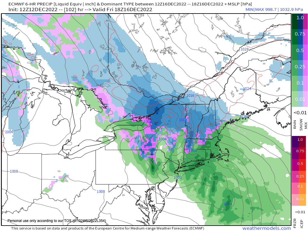
–Heavy wet snow could turn into a major wet snow storm for the mountains of southern VT, the eastern Berkshires and western hilltowns, with some moderate accumulation in the northern Worecester hills
–Stay tuned for potential track and impact changes for Friday’s storm
Now then, before we jump into the weather discussion/details below, let’s check a note from our local and delicious sponsor, #TandemBagelCo, with their newest location in West Springfield, MA.
——————–
A NOTE FROM OUR SPONSOR:
DHTWN Is Sponsored by Members, Patrons & Tandem Bagel Company: No matter the weather, Tandem Bagel is always there for you at several valley locations to make your mornings brighter! With bagels baked fresh daily (including Gluten-Free options), house-whipped cream cheese, coffee, and tons of lunch options, Tandem is the perfect quick stop for lunch, breakfast, or a coffee and bagel to go. Find them in Easthampton, Northampton, Hadley, Florence, and West Springfield, or use their super-streamlined online ordering tool by visiting their website.
——————————————-
***DHTWN DAILY WEATHER REPORT***
——————————————-
NWS ALERTS
–None
DHTWN REMINDER
–The odds of being a human is 1 in 400,000 billion… make it count, even in a small way (see Kurt Vonnegut quote at end of post)
DAILY CELESTIAL (STAR):
–OUR STAR ROSE AT: 7:10am this morning
–OUR STAR WILL SET AT: 4:18pm this evening
–TOTAL DAYLIGHT TIME: 9 hours and 8 minutes
NIGHTLY CELESTIAL (MOON):
–OUR MOON WILL RISE AT: 9:17pm tonight
–OUR MOON WILL SET AT: 11:41am tomorrow morning
–MOON RISE DIRECTION: East-Northeast
–MOON SET DIRECTION: West-Northwest
–MOON PHASE: Waning Gibbous (76.3%)
———————-
DAILY TERRESTRIAL (ZoneCast)
ZONE 1 (Northern Region)
Southern VT, Southwest NH, N. Taconics NY
–High Temps: Upper 20s to Mid 30s
–Low Temps: Low to Mid 10s
–Wind: Northwesterly wind light early, then gusting 15-30mph overnight into Wednesday
–Skies: Mostly Sunny
–Precipitation: None expected today, flurry possible overnight
ZONE 2 (Central Region)
WMass, N. CMass, N. Litchfield County, C./S. Taconics NY
–High Temps: Low to Upper 30s
–Low Temps: Mid to Upper 10s
–Wind: Northwesterly wind light early, then gusting 15-30mph overnight into Wednesday
–Skies: Mostly Sunny
–Precipitation: None
ZONE 3 (Southern Region)
S. CMass, S. Litchfield County, NC.CT, & NE.CT
–High Temps: Mid to Upper 30s
–Low Temps: Upper 10s to Low 20s
–Wind: Northwesterly wind light early, then gusting 15-30mph overnight into Wednesday
–Skies: Mostly Sunny
–Precipitation: None
———————-
WHERE’S DAVE?
–*I’ve been reporting our weather daily here and at https://www.westernmassweather.com for almost 10 years*
–Please visit my this FB page via the app or web like selecting a channel you want to tune into if I’m not auto-kissing your screens
–I’m always here daily, so keep stopping by!
———————-
MORNING DISCUSSION
Good morning everybody, this morning’s report will be delivered by my patented Double–Dashes Presentation Method (DDPM), because well, as it turns out I invented double dashes, and I’m taking ownership of them, so let’s get down to business!
SUMMARY
–We’ve got Atlantic Canada low pressure swirling around
–We also have high pressure nudging northeast toward the Great Lakes and eastern Ontario
–Said coastal low will retrograde (move east to west) toward Maine
–This surface pressure squeeze play will tighten the pressure gradient across the WMass region, and produce gusty winds of 15-30mph at times late today, and especially tonight and tomorrow
–It will be sunny today and tomorrow, with highs mostly in the 30s with lows in the teens
–There will be a wind chill tonight and tomorrow, so bundle up, with highs again in the 30s tomorrow, and lows in the upper 10s to low 20s
–Thursday is our transition day as the primary low pressure system tracks northeast into the northern Ohio Valley
–Clouds will increase with time on Thursday, but it should be dry during the daylight hours
–We’re in a “blocky” pattern, meaning from west to east there is a strong low, a strong high, and a strong low, creating an amplified, undulating wave pattern in the pressure field over eastern United States
–This slows down the movement of storm systems, and is why our upcoming storm should last from Thursday night through Friday night and possibly into Saturday morning
–Given that we won’t have super cold air in place ahead of this system, and assuming that the secondary storm that develops south of Long Island hugs the coastline, milder air should work in to the lower elevations of our region Thursday night into Friday morning
–Still, enough cold should linger and be held in place over the high terrain in the Berkshires, western hilltowns, northern LItchfields, and especially southern VT into southwest NH (and maybe even northernmost CMass) that we’ll see substantial wet snow accumulations there
–Where it stays all snow, it could snow over a foot in some spots, which could cause numerous outages in far northwest MA and southern VT, so stay tuned for updates
–Thursday and Friday both look to reach temps in the 35-40º range, except for low 30s above 1500 feet
–Rain and snow quits Saturday morning, and we’ll have a chilly and drying weekend with sunshine on Sunday lasting into Monday with highs in the 30s
Stay tuned for daily updates, have a great day, and if you missed the order deadline, I still have 2023 weather calendars at the link below: I won’t be doing one next year, so get ’em while you can!
Follow me on Twitter while it’s still a thing.
AND REMEMBER…
“Hello babies. Welcome to Earth. It’s hot in the summer and cold in the winter. It’s round and wet and crowded. On the outside, babies, you’ve got a hundred years here. There’s only one rule that I know of, babies: Goddamn it, you’ve got to be kind.”
–Kurt Vonnegut