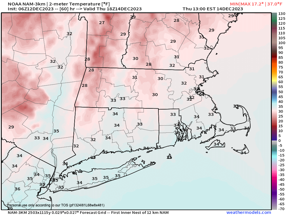
Thursday is the coldest day of the week
TABLE OF CONTENTS
* Daily Celestials (Sun/Moon Data)
* Weekly Weather Nutshell
* Morning Discussion
* TIP: Scroll below for sections, or read all
~~~~~~~~~~~~~~~~~~~~~~
YOUR DAILY CELESTIALS
~~~~~~~~~~~~~~~~~~~~~~
STAR:
–OUR STAR ROSE AT: 7:09am this morning
–OUR STAR WILL SET AT: 4:18pm this evening
–TOTAL DAYLIGHT TIME: 9 hours and 9 minutes
MOON:
–OUR MOON WILL SET AT: 3:44pm this afternoon
–MOON SET DIRECTION: Southwest
–OUR MOON WILL RISE AT: 8:12am tomorrow morning
–MOON RISE DIRECTION: Southeast
–MOON PHASE: New Moon (0.4%)
~~~~~~~~~~~~~~~~~~~~~~
A NOTE FROM OUR SPONSOR
~~~~~~~~~~~~~~~~~~~~~~
Dave Hayes The Weather Nut is Sponsored by Individual Community Members, Patrons, and Tandem Bagel Company… No matter the weather, Tandem Bagel is always there for you at several valley locations to make your mornings brighter! With bagels baked fresh daily (including Gluten-Free options), house-whipped cream cheese, coffee, and tons of lunch options, Tandem is the perfect quick stop for lunch, breakfast, or a coffee and bagel to go. Find them in Easthampton, Northampton, Hadley, Florence, and West Springfield, or use their super-streamlined online ordering tool by visiting their website.
~~~~~~~~~~~~~~~~~~~~~~
YOUR WEEKLY WEATHER NUTSHELL
~~~~~~~~~~~~~~~~~~~~~~
–Northwest wind gusts will decrease through the day and become lighter southwest
–Mostly sunny, or becoming so after early morning clouds in the Berkshires and SVT
–Highs either side of 40º, lows mid to upper 20s
–Cold front approaches tomorrow, partly sunny with a few snow showers possible, otherwise mostly dry
–Highs Wednesday mid to upper 30s with westerly wind gusts 20-30mph behind the front
–Temps drop at night, with lows upper teens to low 20s
–Thursday is the coldest day of the week behind the front, highs in the low to mid 30s, lows in the teens, mostly sunny
–High pressure builds to our south Friday into the weekend with mostly sunny skies expected, and increasing temps
–Highs should climb at least into the mid 40s, maybe a bit higher to near 50º for some
–Our next storm could run up the eastern seaboard after our high pressure scoots east and produce another substantial rainfall with mountain snow possible
~~~~~~~~~~~~~~~~~~~~~~
YOUR MORNING DISCUSSION
~~~~~~~~~~~~~~~~~~~~~~
Good morning everybody, there isn’t too much to discuss today going forward through the weekend, as the Nutshell handles it pretty well.
We’ve got decreasing winds and decreasing clouds today as high pressure builds in, and then an incoming cold front tomorrow which could bring some lake effect snow showers into our region, especially the Taconics, Berkshires, SVT and western hilltowns.
If this comes together, it would be an example of the almost mythical 3-Lake connection of Superior, Huron and Ontario where the wind needs to be from just the right west-northwesterly direction to set up right and produce prolonged, long-stream snow showers.
I’m not convinced, but it’s possible, and I will comment on it tomorrow.
The bottom line is that temps will crest into the 35-40º range Wednesday, and it will become gusty with westerlies of 20-30mph. Then temps will drop to either side of 20º for lows tomorrow night.
Thursday is the coldest day of the weekly stretch with highs in the low to mid 30s, and lows in the teens under sunny skies.
Friday through Sunday produces a milder trend with temps rebounding into the 40s for highs and lows either side of 30º with dry conditions before another coastal storm may get its act together and make a run at us as early as Sunday night, but likely not arriving until Monday morning for what could become a wet morning commute.
Have a great day!
>>> BE KIND <<<
“Hello babies. Welcome to Earth. It’s hot in the summer and cold in the winter. It’s round and wet and crowded. On the outside, babies, you’ve got a hundred years here. There’s only one rule that I know of, babies: Goddamn it, you’ve got to be kind.”
–Kurt Vonnegut
