
Good morning folks, we’re starting out with very warm morning temps well into the 70s with some low 80s already, and high humidity with dewpoints in the 70s. This is the last morning to feature these types of tropical conditions.
We’ve got scattered showers and thunderstorms moving through later this morning and through the afternoon (again, many will stay dry), but changes are coming after this final heat wave day with more showers possible Wednesday night and Thursday prior to kicking the high humidity seaward for the weekend into early next week, but before we dive into all of the weather details below, let’s check a note from our local and delicious sponsor, #TandemBagelCo, with their newest location in West Springfield, MA.
——————–
A NOTE FROM OUR SPONSOR:
DHTWN Is Sponsored by Members, Patrons & Tandem Bagel Company: No matter the weather, Tandem Bagel is always there for you at several valley locations to make your mornings brighter! With bagels baked fresh daily, house-whipped cream cheese, coffee, and tons of lunch options, Tandem is the perfect quick stop for lunch, breakfast, or a coffee and bagel to go. Find them in Easthampton, Northampton, Hadley, Florence (and now West Springfield!), or use their super-streamlined online ordering tool by visiting their website: https://www.tandembagelco.com
——————————————-
***DHTWN DAILY WEATHER REPORT***
——————————————-
NWS ALERTS
–Heat Advisories are up through tonight at 8pm for all of WMass except the northern Berkshires, all of CMass and all of N.CT
–Heat indices will push into the low 100s for some today
DHTWN REMINDER
–The odds of being a human is 1 in 400 trillion… make it count, even in a small way (see Kurt Vonnegut quote at end of post)
DAILY CELESTIAL (STAR):
–OUR STAR ROSE AT: 5:51am this morning
–OUR STAR WILL SET AT: 7:59pm this evening
–TOTAL DAYLIGHT TIME: 14 hours and 8 minutes
DAILY CELESTIAL (MOON):
–OUR MOON WILL RISE AT: 6:43pm this evening
–OUR MOON WILL SET AT: 3:32am tomorrow morning
–MOON RISE DIRECTION: Southeast
–MOON SET DIRECTION: Southwest
–MOON PHASE: Waxing Gibbous 90.0%
———————-
DAILY TERRESTRIAL (ZoneCast)
ZONE 1 (Northern Region)
Southern VT, Southwest NH, N. Taconics NY
–High Temps: Low to Mid 80s, a few Upper 80s readings
–Low Temps: Upper 50s to Low 60s
–Humidity: Dewpoints upper 60s to low 70s, very muggy, but lowering somewhat overnight
–Wind: Light southwesterly to westerly gusts to 25mph
–Skies: Partly Sunny on average
–Precipitation: Scattered showers or a thunderstorm by late morning into the afternoon, drying overnight
ZONE 2 (Central Region)
WMass, N. CMass, N. Litchfield County, C./S. Taconics NY
–High Temps: Mid 80s to Low 90s
–Low Temps: Upper 50s to Mid 60s
–Humidity: Dewpoints upper 60s to mid 70s, very muggy, but lowering somewhat overnight
–Wind: Light southwesterly to westerly gusts to 25mph
–Skies: Partly Sunny on average
–Precipitation: Scattered showers or a thunderstorm by late morning into the afternoon, drying overnight
ZONE 3 (Southern Region)
S. CMass, S. Litchfield County, NC.CT, & NE.CT
–High Temps: Low to Mid 90s
–Low Temps: Low to Upper 60s
–Humidity: Dewpoints upper 60s to low 70s, very muggy, but lowering somewhat overnight
–Wind: Light southwesterly to westerly gusts to 25mph
–Skies: Partly Sunny on average
–Precipitation: Scattered showers or a thunderstorm by late morning into the afternoon, drying overnight
———————-
WEATHER REPORT
Good morning everybody, I am happy for the folks out there who are heat and humidity lovers, because you’ve gotten two prolonged heat waves this Summer after a very cool June start.
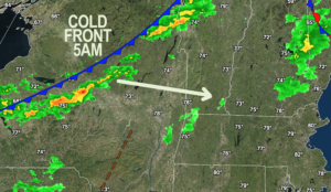
For the rest of us, relief is coming as today is the last day of this heat wave, as a cold front is on the way through the region this afternoon and tonight, but it will stall near the south coast by tomorrow (more on that later).
In the meantime, we’ve got light southwest flow, and very warm morning temps and high humidity, so before the cold front swings in today, we’ll raise temps well into the 80s for all of us, and more like the upper 80s to mid the 90s for the Pioneer Valley points south and east into CMass, and northern CT.
A line of showers is already slicing across central NY this morning, and so by late morning into and through the afternoon, we’ll see the potential for scattered showers and thunderstorms, one or two of which may become strong to severe with gusty winds and torrential rainfall.
This activity will end this evening, and our lows should be much cooler compared to this morning, bottoming out in the upper 50s to upper 60s from north to south.
For Wednesday, low pressure will develop and track east along the stalling front, and so while a partly sunny day is expected with highs in the low to mid 80s, more showers will develop across the region, but mostly south of the Pike during the late afternoon and evening, with only some isolated showers for us north of the Pike. Lows will drop to the low to mid 60s.
On Thursday, a second reinforcing cold front will be moving through at night, and that will be the front that finally delivers the low-humidity air mass many of us have been craving for days.
The day time a few isolated showers with highs in the low to mid 80s under partly sunny skies, but we will hopefully see a bit more numerous showers Thursday night, though in this pattern we’ve been in, I wouldn’t get my hopes up. Lows Thursday night will range from 55-60º.
The Canadian air mass is in on Friday, with much more refreshing air, highs in the mid 70s to low 80s, and lows in the low to mid 50s. Friday night is the night to open all the windows and flush the air through!
The weekend looks gorgeous with highs in the mid to upper 70s Saturday and low to mid 80s Sunday with lows in the 50s to low 60s.
By early next week, we’re still in the upper 70s to low 80s, and it looks like the heat will have left the building for the foreseeable future!
Thanks for reading, have a great day, and please follow me on Twitter if you’re there…
AND REMEMBER…
“Hello babies. Welcome to Earth. It’s hot in the summer and cold in the winter. It’s round and wet and crowded. On the outside, babies, you’ve got a hundred years here. There’s only one rule that I know of, babies: Goddamn it, you’ve got to be kind.”
–Kurt Vonnegut