
Good morning folks, we’re starting out with temps in the 60s and 70s and dew points in the 65-70º range with patchy fog, notably in the Berkshires and southern VT.
We had some record breaking heat yesterday with Westfield breaking a record at 96º (94º was the old record back in 2012), and we tied the record of 95º at Westover Air Force Base in Chicopee (set back in 1944).
Temps will be tamped today, but more showers and storms are possible with high humidity today, tomorrow, and Sunday with hotter temps (and less showers) followed by an extended unsettled period with the heat breaking (and humidity lingering) into the middle of next week, but before we dive into all of the weather details below, let’s check a note from our local and delicious sponsor, #TandemBagelCo, with their newest location in West Springfield, MA.
——————–
A NOTE FROM OUR SPONSOR:
DHTWN Is Sponsored by Members, Patrons & Tandem Bagel Company: No matter the weather, Tandem Bagel is always there for you at several valley locations to make your mornings brighter! With bagels baked fresh daily, house-whipped cream cheese, coffee, and tons of lunch options, Tandem is the perfect quick stop for lunch, breakfast, or a coffee and bagel to go. Find them in Easthampton, Northampton, Hadley, Florence (and now West Springfield!), or use their super-streamlined online ordering tool by visiting their website: https://www.tandembagelco.com
——————————————-
***DHTWN DAILY WEATHER REPORT***
——————————————-
NWS ALERTS
–Heat Advisories are up through this evening for all of WMass except the northern Berkshires, all of CMass, and all of northern CT
DHTWN REMINDER
–The odds of being a human is 1 in 400 trillion… make it count, even in a small way (see Kurt Vonnegut quote at end of post)
DAILY CELESTIAL (STAR):
–OUR STAR ROSE AT: 5:47am this morning
–OUR STAR WILL SET AT: 8:04pm this evening
–TOTAL DAYLIGHT TIME: 14 hours and 17 minutes
DAILY CELESTIAL (MOON):
–OUR MOON WILL RISE AT: 1:55pm this afternoon
–OUR MOON WILL SET AT: 11:59pm tonight
–MOON RISE DIRECTION: East-Southeast
–MOON SET DIRECTION: West-Southwest
–MOON PHASE: Waxing Gibbous 49.8%
———————-
DAILY TERRESTRIAL (ZoneCast)
ZONE 1 (Northern Region)
Southern VT, Southwest NH, N. Taconics NY
–High Temps: Upper 80s to Low 90s
–Low Temps: Mid to Upper 60s
–Humidity: Dewpoints Mid 60s to Low 70s (very humid)
–Wind: Light southwesterly to calm at times
–Skies: Mostly cloudy, with partly sunny periods possible
–Precipitation: Scattered showers and thunderstorms possible in the afternoon / evening
ZONE 2 (Central Region)
WMass, N. CMass, N. Litchfield County, C./S. Taconics NY
–High Temps: Upper 80s to Mid 90s
–Low Temps: Upper 60s to Low 70s
–Humidity: Dewpoints Mid 60s to Low 70s (very humid)
–Wind: Light southwesterly to calm at times
–Skies: Mostly cloudy, with partly sunny periods possible
–Precipitation: Scattered showers and thunderstorms possible in the afternoon / evening
ZONE 3 (Southern Region)
S. CMass, S. Litchfield County, NC.CT, & NE.CT
–High Temps: Upper 80s to Mid 90s
–Low Temps: Upper 60s to Low 70s
–Humidity: Dewpoints Mid 60s to Low 70s (very humid)
–Wind: Light southwesterly to calm at times
–Skies: Mostly cloudy, with partly sunny periods possible
–Precipitation: Scattered showers and thunderstorms possible in the afternoon / evening
———————-
WEATHER REPORT
Good morning everybody, this hot, soupy slog we’re in the midst of continues into early next week, so take some slow, preferably-inside deep breaths (the Air Quality Alerts have expired for parts of WMass this morning) and keep on hydrating and staying cool when you can, because this Bermuda High is large and in charge of keeping the heat and humidity in the region over the next several days!
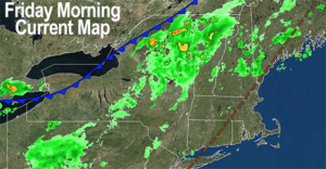
For today, we’ve got a cold front washing out into the region as it tracks southeast into New England, dissolving in the face of that giant dome of high pressure to our south, which is serving as a southwesterly heat and humidity pump driving our heat and humidity during these early August days.
We also have a mid-level wave that should pass through CT or along the southern New England coastline today.
The combo of the weakening front, this mid-level wave, and our very warm to hot temps and high humidity should help produce scattered showers, downpours and thunderstorms this afternoon and early evening.
I unfortunately do not know where and who is going to get what and when, as this classic summer convective weather is hit or miss by its nature. If you’re doing outdoor stuff, you have to have the Plan B rain contingency in case a shower or storm happens to roll over your quarter-acre parcel where you’ve got outdoor plans.
Highs today will reach the upper 80s to mid 90s for most of us, and heat indices will push up into the upper 90s for some, which is why the Heat Advisories have been hoisted.
For tonight, showers and storms should weaken after sunset, and high humidity will continue with patchy fog late as lows cool down into the mid 60s to low 70s.
For Saturday, we’ve got another very warm and very humid day under partly sunny skies with highs in the mid to upper 80s and again, scattered showers and thunderstorms expected that will be hit or miss.
Many folks stay dry today and tomorrow, some folks get soaked, that’s the gig.
——————–
A SONG TO SUPPORT WMASS FOOD BANK
You can support the Food Bank when you purchase (for a dollah) the DHTWN Theme Song written by my good friend and amazing drummer J.J. O’Connell.
It’s fun, bouncy and catchy, and if you want to pay more than the $1, it all goes to help the Food Bank.
At least give it a listen (I played the bass part on it!), and chip in to help your neighbors in need if you’re able, thank you!
——————–
Lows Saturday night dip into the upper 60s to low 70s after any afternoon/evening showers and storms weaken and quit.
I also think that while Sunday could feature an isolated shower or storm, we should see less rainy activity. Still, it will be hotter for sure! Highs will reach the upper 80s to mid 90s and it will be humid, so Heat Advisories may need hoisting again by the NWS.
It should be mostly sunny with an isolated shower or storm possible later in the afternoon, and lows will dip into the upper 60s to low 70s with humidity continuing, and a shower or storm will be possible.
For Monday through Wednesday, changes are afoot.
A strong cold front is going to push deeper into our region, though it will also be slowed down by this Bermuda High to our south.
The difference is that this time, the front likely pushes through the region fully by mid to late week.
However, Monday looks like the last hot day with highs in the upper 80s to low 90s, with showers and storms in the afternoon.
Then the front moves through slowly Monday night into Tuesday, and the heat breaks most likely by Tuesday, though it may be as late as Wednesday.
When it does break, highs will sit down into the low to mid 80s for the most part with some upper 70s possible by mid week in the Berkshires and high terrain.
Showers are going to be possible Monday through Wednesday, with Thursday being the earliest day we could expect to get on the westerly, drier side of the front, with sunshine developing and much lower humidity.
Hang in there folks, it’s a slog, but it looks like we’re on the way to more comfortable and seasonable conditions.
Thanks for reading, have a great day, and please follow me on Twitter if you’re there…
AND REMEMBER…
“Hello babies. Welcome to Earth. It’s hot in the summer and cold in the winter. It’s round and wet and crowded. On the outside, babies, you’ve got a hundred years here. There’s only one rule that I know of, babies: Goddamn it, you’ve got to be kind.”
–Kurt Vonnegut