
Good morning folks, we have a pleasant morning out there but the heat will most certainly be ON today with highs climbing well into the 90s, though our hot air mass will be well mixed and keep humidity suppressed a bit.
Regardless, we’re in the middle of our second heat wave, and humidity will surge tomorrow through Monday with more hot temps, periods of showers, downpours and thunderstorms, and an expected Coolening starting Tuesday, but before we dive into all of the weather details below, let’s check a note from our local and delicious sponsor, #TandemBagelCo, with their newest location in West Springfield, MA.
——————–
A NOTE FROM OUR SPONSOR:
DHTWN Is Sponsored by Members, Patrons & Tandem Bagel Company: No matter the weather, Tandem Bagel is always there for you at several valley locations to make your mornings brighter! With bagels baked fresh daily, house-whipped cream cheese, coffee, and tons of lunch options, Tandem is the perfect quick stop for lunch, breakfast, or a coffee and bagel to go. Find them in Easthampton, Northampton, Hadley, Florence (and now West Springfield!), or use their super-streamlined online ordering tool by visiting their website: https://www.tandembagelco.com
——————————————-
***DHTWN DAILY WEATHER REPORT***
——————————————-
NWS ALERTS
–Heat Advisories are up from Thursday morning through Friday 8pm for much of WMass except the Berkshires, all of northern CT, and CMass
–Heat Advisories are up for today only for southwest NH and easternmost Windham County VT
–Heat indices (the feels-like temp when combining air temps and dew point temps) will be pushing over 100º Thursday, and into the upper 90s for Friday
–BOTTOM LINE: It’s hotter Thursday and less humid, but less hot and oppressively humid for Friday
DHTWN REMINDER
–The odds of being a human is 1 in 400 trillion… make it count, even in a small way (see Kurt Vonnegut quote at end of post)
DAILY CELESTIAL (STAR):
–OUR STAR ROSE AT: 5:46am this morning
–OUR STAR WILL SET AT: 8:05pm this evening
–TOTAL DAYLIGHT TIME: 14 hours and 19 minutes
DAILY CELESTIAL (MOON):
–OUR MOON WILL SET AT: 11:30pm tonight
–OUR MOON WILL RISE AT: 1:55pm tomorrow afternoon
–MOON SET DIRECTION: West-Southwest
–MOON RISE DIRECTION: East-Southeast
–MOON PHASE: Waxing Crescent 39.1%
———————-
DAILY TERRESTRIAL (ZoneCast)
ZONE 1 (Northern Region)
Southern VT, Southwest NH, N. Taconics NY
–High Temps: Upper 80s to Mid 90s
–Low Temps: Mid to Upper 60s
–Humidity: Dewpoints low/mid 60s
–Wind: Light southwesterly
–Skies: Mostly sunny after low clouds/fog burn off
–Precipitation: Isolated showers and thunderstorms, especially in southwest VT, but anyone could see an isolated shower this late afternoon to early evening
ZONE 2 (Central Region)
WMass, N. CMass, N. Litchfield County, C./S. Taconics NY
–High Temps: Low to Upper 90s
–Low Temps: Mid 60s to Low 70s
–Humidity: Dewpoints low/mid 60s
–Wind: Light southwesterly
–Skies: Mostly sunny after low clouds/fog burn off
–Precipitation: Isolated showers and thunderstorms, especially west of the I-91 corridor, but anyone could see an isolated shower this late afternoon to early evening
ZONE 3 (Southern Region)
S. CMass, S. Litchfield County, NC.CT, & NE.CT
–High Temps: Low to Upper 90s
–Low Temps: Upper 60s to Low 70s
–Humidity: Dewpoints low/mid 60s
–Wind: Light southwesterly
–Skies: Mostly sunny after low clouds/fog burn off
–Precipitation: Isolated showers and thunderstorms, especially west of the I-91 corridor, but anyone could see an isolated shower this late afternoon to early evening
———————-
WEATHER REPORT
Good morning everybody, we’re facing down another 4 days of heat and humidity, and so we must rise up and wilt!!
No wait, I mean get up and seize the soup!!
That’s wrong too, I mean get up and shake your sweaty maker!!
I guess my brain isn’t working right this morning, but the idea is that if you love this weather, I suggest you soak it up and bottle it and put it in the freezer to take out in Winter, kind of like a good summer pesto or red sauce.
But if you don’t, remember that it’s August now, and we’re going to be experiencing an episode of my favorite nature-based TV show called “The Coolening” by the middle of next week, so until then, do what you can to stay cool, stay hydrated, reduce sun/heat exposure, and take breaks if you must be outside working in this heat and humidity.
SUMMAH-RY
–Strong Bermuda high pressure over the western Atlantic Ocean will continue to pump up the hot and humid jams on a steady southwesterly flow into New England through Monday
–After that point, a strong upper trough bowls southeast into the Great Lakes and then the Northeast U.S., suppressing that Bermuda high further east and out to sea by mid week, cooling us down #BuhBye
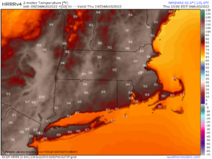
–For today, however, we’re hot and and fairly humid, with highs in the upper 80s in the southern Greens to upper 90s in the Pioneer Valley in MA and CT, with many low to mid 90s readings elsewhere
–Dewpoints will be in the low to mid 60s, so humid, but not oppressively so.
–This combo puts heat indices into the upper 90s to low 100s, so stay hydrated and stay cool as you can
–We should see some slow-moving isolated showers, downpours or a thunderstorm by late this afternoon into early evening
–While a storm or two may become strong with some gusty wind, it’s more likely these remain heavy rainers more than anything, where they do form (some stay dry)
–Tonight, humidity builds and pours into the region into Friday
–Lows will be in the mid 60s to low 70s, but by tomorrow, highs will reach the upper 80s to low 90s with dew points climbing into the low to mid 70s
——————–
CATCHY TUNE TO SUPPORT WMASS FOOD BANK
You can support the Food Bank when you purchase for a buck the DHTWN Theme Song written by my good friend and amazing drummer J.J. O’Connell.
It’s quite catchy, and if you want to pay more than the $1, it all goes to help the Food Bank.
At least give it a listen (I played the bass on it!), and chip in to help your neighbors in need if you’re able, thank you!
——————–
–This combo will put heat indices into the upper 90s for Friday, and it will be Soupy Sales time for southwest New England (i.e. us)
–A weak cold front will be moving into the region, and with the added moisture and weak steering currents, we have a much better chance for afternoon scattered showers, downpours and thunderstorms, and folks, it could DELUGE at times tomorrow
–Some street flooding could result from any slow-moving dumpers
–Lows Friday night will drop into the 65-70º range and some showers or a storm should continue into the first part of the night
–For Saturday, more isolated to scattered showers and thunderstorms are expected with mostly cloud skies and highs in the mid to upper 80s with continued high humidity
–Lows will only sit in the upper 60s to low 70s, humid
–Sunday looks like a hotter day with substantial humidity, but while an isolated shower or storm can’t be ruled out, it should be a more stable atmosphere so just mostly sunny skies expected and hot. Lows in the low 70s
–Monday into Monday night and Tuesday is the final heat day, with highs in the mid 80s to low 90s with afternoon showers and thunderstorms possible as a cold front moves into the region
–By Tuesday, we’re moving into a new pattern which hopefully will last, but that’s not set in stone
–Highs should be in the mid 70s to low 80s with partly sunny skies, so those that don’t like being soup ingredients have something to look forward to!
Thanks for reading, have a great day, and please follow me on Twitter if you’re there…
AND REMEMBER…
“Hello babies. Welcome to Earth. It’s hot in the summer and cold in the winter. It’s round and wet and crowded. On the outside, babies, you’ve got a hundred years here. There’s only one rule that I know of, babies: Goddamn it, you’ve got to be kind.”
–Kurt Vonnegut