
TABLE OF CONTENTS
* Daily Celestials (Sun/Moon Data)
* Sponsor Section
* Morning Discussion
* TIP: Scroll to your section, or read all
~~~~~~~~~~~~~~~~~~~~~~
YOUR DAILY CELESTIALS
~~~~~~~~~~~~~~~~~~~~~~
STAR:
–OUR STAR ROSE AT: 5:46am this morning
–OUR STAR WILL SET AT: 8:06pm this evening
–TOTAL DAYLIGHT TIME: 14 hours and 20 minutes
MOON:
–OUR MOON WILL SET AT: 8:08pm tonight
–MOON SET DIRECTION: West-Northwest
–OUR MOON WILL RISE AT: 5:36am this afternoon
–MOON RISE DIRECTION: East-Northeast
–MOON PHASE: New Moon (1.1%)
~~~~~~~~~~~~~~~~~~~~~~
>>> A NOTE FROM OUR WEEKEND SPONSOR <<<
Dave Hayes The Weather Nut is Sponsored by Individual Community Members, Patrons, and Gerard, Ghazey & Bates, P.C. GGBPC is a Northampton-based law firm regarded as the voice of pragmatic and well-reasoned estate planning, elder law and tax guidance in Western Massachusetts. The firm specializes in estate planning law, and expertly handles other matters such as Elder Law, Tax Law, as well as Real Estate purchase, sales, and refinance transactions. Contact GGBPC today to see how they can help!
~~~~~~~~~~~~~~~~~~~~~~
YOUR MORNING DISCUSSION
~~~~~~~~~~~~~~~~~~~~~~
Good morning folks, we’ve got three more days of very humid conditions, along with chances for showers, downpours and thunderstorms.
Yesterday we saw a microburst in Simsbury / Granby CT area which produced a 70mph wind gusts until an anemometer failed, and numerous reports of tree damage, outages, and property damage were produced, and the Windsor area was also affected.
This may happen again later this afternoon or into the early evening as conditions are similar.
We have some morning showers north of the Rt. 2 corridor due to a wave departing northern New England, and behind it, drier air aloft is being pulled into the region which will produce partly to mostly sunny skies today into the mid to late afternoon.
I didn’t anticipate as much sun today when reporting yesterday, and so today will become another very warm to even hot and humid day with highs in the 85-90º range, which will push heat indices into the mid 90s for some, or a bit higher, especially in the southern valley through the Holyoke to Hartford stretch, east over to the Worcester metro.
By later this afternoon, very humid air will combine with an incoming disturbance that will produce another region of showers, downpours and thunderstorms. A microburst is again possible this later afternoon, so if you see the wind kicking up or a sudden burst of heavier rain with wind, get inside immediately and away from windows.
These are quick-hitting, damaging events, and I even saw a picture of a tree straight through the second floor of a house yesterday, so bottom floor away from windows.
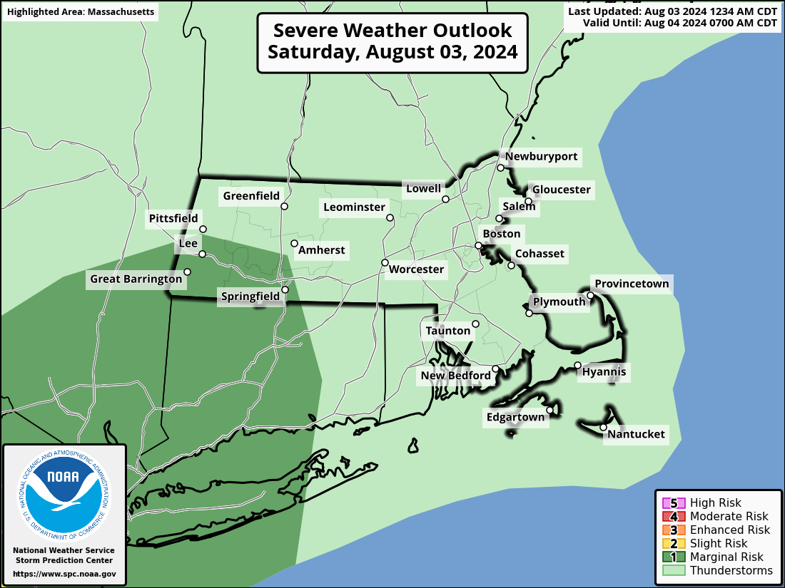
Street flooding will also be possible with any stronger to severe storms, and the SPC has included the southern Berkshires and Litchfield County in a Level 1 out of 5 severe storm risk for today/tonight.
Activity may persist past midnight tonight in spots, and lows will only drop to the 65-70º range with patchy fog possible, as we saw today.
For Sunday, more clouds are expected and so highs should only reach the low to mid 80s, but it will still be quite humid, and another wave will move through by afternoon and bring some more scattered showers and thunderstorms that should not last as long into the night as tonight’s activity is expected.
Monday represents the final day of this combined very warm to hot and very humid pattern as a cold front will be working southeast from the northwest, which will produce another round of showers, downpours and thunderstorms, some of which may become strong to severe in the afternoon and evening.
Highs should reach the 85-90º range with dewpoints near 70º, with mix of sun and clouds.
The cold front swings through Monday night with lows in the 60s, and by the rest of next week, highs should be firmly residing in the 70s throughout, with lows in the 50s, so the temps will most definitely be tamped.
However, that front may stall somewhere down in CT or near the south coast, and that will keep the threat for scattered showers in the greater WMass region during each afternoon next week with mixed skies of sun and clouds at times.
By late week into next weekend, we’ll have to see how that front interacts with what likely becomes Hurricane Debby’s tropical remnants.
For now, it looks like it could graze the south coast and especially the Cape and the Islands so folks with interests down there need to pay attention to future forecasts and updates.
I will check in later with an update on our potential summer-stormy weather later today, have a great one!
HAIKU OF THE DAY:
Humidity, leave
Go, unwelcome are you, stop
Bring on Autumn, now
“Follow your bliss and the universe will open doors for you where there were only walls.”
― Joseph Campbell