
Good morning folks, we’ve got summah weathah locked into the region through next Tuesday it appears, though today will be a nice lower-humidity break in the action. Friday is looking replete with slow-moving downpours for some folks, with more isolated afternoon activity Saturday into early next week with copious rain possible Tuesday, but before we dive into all of the weather details below, let’s check a note from our local and delicious sponsor, #TandemBagelCo, with their newest location in West Springfield, MA.
——————–
A NOTE FROM OUR SPONSOR:
DHTWN Is Sponsored by Members, Patrons & Tandem Bagel Company: No matter the weather, Tandem Bagel is always there for you at several valley locations to make your mornings brighter! With bagels baked fresh daily, house-whipped cream cheese, coffee, and tons of lunch options, Tandem is the perfect quick stop for lunch, breakfast, or a coffee and bagel to go. Find them in Easthampton, Northampton, Hadley, Florence (and now West Springfield!), or use their super-streamlined online ordering tool by visiting their website: https://www.tandembagelco.com
——————————————-
***DHTWN DAILY WEATHER REPORT***
——————————————-
NWS ALERTS
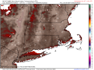
–Heat Advisories are up from Thursday morning through Friday 8pm for much of WMass except the Berkshires, all of northern CT, CMass, southwest NH and easternmost Windham County VT for heat indices pushing over 100º Thursday, and into the upper 90s for Friday with combos of high heat and humidity (more humidity on Friday).
DHTWN REMINDER
–The odds of being a human is 1 in 400 trillion… make it count, even in a small way (see Kurt Vonnegut quote at end of post)
DAILY CELESTIAL (STAR):
–OUR STAR ROSE AT: 5:45am this morning
–OUR STAR WILL SET AT: 8:06pm this evening
–TOTAL DAYLIGHT TIME: 14 hours and 21 minutes
DAILY CELESTIAL (MOON):
–OUR MOON WILL SET AT: 11:06pm tonight
–OUR MOON WILL RISE AT: 12:43pm tomorrow afternoon
–MOON SET DIRECTION: West
–MOON RISE DIRECTION: East-Southeast
–MOON PHASE: Waxing Crescent 29.2%
———————-
DAILY TERRESTRIAL (ZoneCast)
ZONE 1 (Northern Region)
Southern VT, Southwest NH, N. Taconics NY
–High Temps: Low to Mid 80s
–Low Temps: Low to Mid 60s
–Humidity: Dewpoints in the 50s to low/mid 60s = more comfy
–Wind: Light southwesterly
–Skies: Mostly sunny after low clouds/fog burn off
–Precipitation: None
ZONE 2 (Central Region)
WMass, N. CMass, N. Litchfield County, C./S. Taconics NY
–High Temps: Mid 80s to Low 90s
–Low Temps: Low to Mid 60s
–Humidity: Dewpoints in the 50s to low/mid 60s = more comfy
–Wind: Light southwesterly
–Skies: Mostly sunny after low clouds/fog burn off
–Precipitation: None
ZONE 3 (Southern Region)
S. CMass, S. Litchfield County, NC.CT, & NE.CT
–High Temps: Mid 80s to Low 90s
–Low Temps: Mid to Upper 60s
–Humidity: Dewpoints in the 50s to low/mid 60s = more comfy
–Wind: Light southwesterly
–Skies: Mostly sunny after low clouds/fog burn off
–Precipitation: None
———————-
WEATHER REPORT
Good morning everybody, please do post your sunset pics below from last night. Sadly I missed it, but I was having fun rehearsing with a killer funk band called Soul Magnets for a gig with them that I’m subbing on bass coming up this Sunday 6-8pm at the Berkshire Botanical Gardens in Stockbridge for a fundraiser that supports the Western Mass Food Bank.
You should come if you’re in the Berkshires and believe in the Food Bank’s mission (I’ve donated every to them for the past decade).
It’s gonna be a total blast, but further down this post you’ll find an easy, one-dollar way to support the Food Bank’s work and get the DHTWN theme song, too!
As for our weather today, any morning fog burns off and reveals a lovely day with high pressure building through the entire eastern seaboard.
This will produce mostly sunny skies with highs in the mid 80s to low 90s for most of us, with some low 80s way up in the mountains of SVT and the Monadnock Region of SWNH.
Lows will drop into the low to upper 60s from north to south and humidity will start increasing by Thursday morning.
Thursday is going to be the hottest day we see for the next week and possibly longer as I am eyeing a pattern change to more of a northwest and cooler flow by mid to late next week.
Highs Thursday will reach the low to upper 90s with dewpoints in the upper 60s to low 70s producing heat indices into the low 100s, so it’ll be key to hydrate tomorrow find ways to stay cool or cool down. Lows will only sit down to near 70º with an isolated shower or t-storm possible.
——————–
CATCHY TUNE TO SUPPORT WMASS FOOD BANK
You can support the Food Bank when you purchase for $1 the DHTWN Theme Song written by my good friend and amazing drummer J.J. O’Connell.
https://spouse.bandcamp.com/track/the-weather-nut-theme-ft-dave-hayes-2
It’s quite catchy, and if you want to pay more than the $1, it all goes to help the Food Bank.
At least give it a listen, and chip in to help your neighbors if you’re able, thank you!
——————–
By Friday, we are going to have a veritable flood of water vapor (water in its gaseous form) push into the region aloft and ahead of a slow-moving frontal boundary.
With weak wind fields in place, we should see slow-moving showers and downpours with some non-severe thunderstorms by Friday afternoon scattered about the region. Some folks could see 1-2″ of rain, while some’ll get little to none.
Highs will be very warm to hot, reaching the mid 80s to mid 90s, but the humidity will be way up into oppressive levels, reaching the 70s, possibly even in the mid to upper 70s, so downpours would be tropical in spots. #Deluge
Friday night scattered showers and storms continue with lows in the upper 60s.
Saturday should feature scattered afternoon showers and storms as well with highs in the mid to upper 80s, and lows near 70º as humidity continues.
Sunday will see the Bermuda high flex and flare back up, pushing highs back into the upper 80s to low/mid 90s, but we should see less shower activity on that day.
By early next week highs look to reach the 85-90º range with continued humidity ahead of a pattern-changing cold front that may bring periods of heavy rain on Tuesday before we sweep this moist mess east and out of here, with the potential for much drier and cooler air to arrive by mid week.
This writer will be consulting with Mother Nature to make this happen forthwith, now, with haste, and yesterday, thank you very much!
Thanks for reading, have a great day, and please follow me on Twitter if you’re there…
AND REMEMBER…
“Hello babies. Welcome to Earth. It’s hot in the summer and cold in the winter. It’s round and wet and crowded. On the outside, babies, you’ve got a hundred years here. There’s only one rule that I know of, babies: Goddamn it, you’ve got to be kind.”
–Kurt Vonnegut