
TABLE OF CONTENTS
* Daily Celestials (Sun/Moon Data)
* Sponsor Note
* Join My Newsletter
(& get my Top12WMassStorms ebook!)
* Morning Discussion
* TIP: Scroll below for sections, or read all
~~~~~~~~~~~~~~~~~~~~~~
YOUR DAILY CELESTIALS
~~~~~~~~~~~~~~~~~~~~~~
STAR:
–OUR STAR ROSE AT: 6:10am this morning
–OUR STAR WILL SET AT: 7:33pm this evening
–TOTAL DAYLIGHT TIME: 13 hours and 23 minutes
MOON:
–OUR MOON WILL RISE AT: 11:24pm tonight
–MOON RISE DIRECTION: Northeast
–OUR MOON WILL SET AT: 3:47am this afternoon
–MOON SET DIRECTION: Northwest
–MOON PHASE: Waxing Crescent (49.5%)
~~~~~~~~~~~~~~~~~~~~~~
A NOTE FROM OUR SPONSOR
~~~~~~~~~~~~~~~~~~~~~~
Dave Hayes The Weather Nut is Sponsored by Individual Community Members, Patrons, and Tandem Bagel Company… No matter the weather, Tandem Bagel is always there for you at several valley locations to make your mornings brighter! With *New Pizza Bagels(!)*, along with bagels baked fresh daily (including Gluten-Free options), house-whipped cream cheese, coffee, and tons of lunch options, Tandem is the perfect quick stop for lunch, breakfast, or a coffee and bagel to go.
You can either 1) visit them in Easthampton, Northampton, Hadley, Florence, and/or West Springfield, 2) hire them to cater your next event, or 3) use their super-streamlined online ordering tool by visiting their website and clicking the “Catering” or “Order Online” links.
~~~~~~~~~~~~~~~~~~~~~~
DAVE’S WEEKLY NEWSLETTER (Top 12 WMass Storms)
DAVE’S MOBILE APP (Late 2024 Release)
~~~~~~~~~~~~~~~~~~~~~~
YOUR MORNING DISCUSSION
~~~~~~~~~~~~~~~~~~~~~~
Good morning folks, we’ve got some patchy fog out there this morning, but that will burn off as temps come up, and highs rise into the 75-80º range.
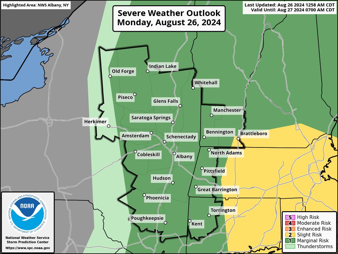
We’ll have some sunshine to enjoy early, and then I’ll be watching (all day and evening, with updated reports) an upper trough swing southeast through the region which will help to provide coldler air aloft to destabilize the lower and mid levels of the atmosphere.
These steeper thermal lapse rates (i.e. how quickly temps fall, decrease, or “lapse” with height) combined with a lower freezing level due to this trough, should help produce thunderstorms that will be capable of updrafts which reach up into the freezing layer and potentially produce larger hail which is our main storm threat today (localized damaging wind gusts, and torrential rain with street flooding are other threats).
As far as timing, it’s mostly Noon to 8pm, though some cells may fire before noon in the high terrain, and some may linger past 8pm.
As far as location, the severe storm threat is more along and east of the I-91 corridor and Pioneer Valley, especially into central MA, eastern parts of southwest NH, and northeast CT.
It will be fairly humid today with dewpoints in the 60s, but not oppressive.
Activity will die out tonight as the trough and impulse continues off to the southeast, and lows will drop into the mid to upper 50s under partly cloudy skies with patchy fog developing.
For Tuesday, some high pressure moves into the region and gives us a mostly sunny day, with highs in the low 80s and lows in the low 60s under mostly clear skies.
Surface high pressure will continue to track south of us and help produce a southwest flow of very warm and very humid air into the region for Wednesday, with highs forecast to reach the mid to upper 80s, and possibly 90º in a few spots. In addition, dewpoints will push into the low to mid 70s so it will be oppressively humid and tropical feeling on Wednesday.
This will help to fuel more strong to severe thunderstorms, this time mainly along and south of the Pike on Wednesday afternoon.
Storms and showers could last into Wednesday evening, and then dissipate as a cold front clears our region and drops temps down into the upper 50s.
The late week period looks lovely, with cooler and drier air, and mostly sunny skies with highs in the low to mid 70s and lows in the low to mid 50s as much lower humidity overspreads the region.
However, by the weekend, another strong frontal boujndary may push into and get hung up in the greater WMass region witih more shower potential.
I will be in the digital saddle and updating through the course of today, and hopefully our severe weather threat will be a bust.
Thunderstorms are cool, but I’m not a fan of large hail and damaging wind.
Have a great day!
“Follow your bliss and the universe will open doors for you where there were only walls.”
― Joseph Campbell