
>>> YOUR DAILY CELESTIALS <<<
STAR:
–OUR STAR ROSE AT: 6:09am this morning
–OUR STAR WILL SET AT: 7:34pm this evening
–TOTAL DAYLIGHT TIME: 13 hours and 25 minutes
MOON:
–OUR MOON WILL RISE AT 4:48pm this afternoon
–MOON RISE DIRECTION: Southeast
–OUR MOON WILL SET AT: 1:17am tomorrow morning
–MOON SET DIRECTION: Southwest
–MOON PHASE: Waxing Gibbous (72.4%)
~~~~~~~~~~~~~~~~~~~~~~
>>> DAVE’S WEEKLY WEATHER NUTSHELL <<<
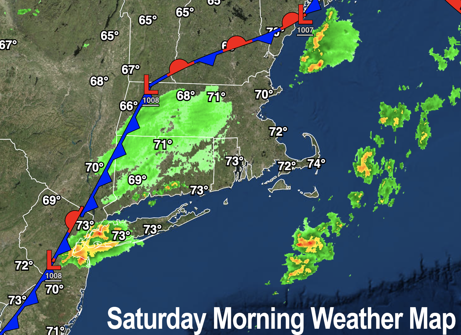
–A cold front is moving through the region this morning and early afternoon
–Clouds with a few light showers, drizzle or patchy fog are expected, trending to partly sunny later
–A few additional isolated showers or a thunderstorm are possible this afternoon into very early evening, especially east of the I-91 corridor, lows in the 50s
–Lowering humidity by tonight into tomorrow under partly sunny skies with highs Sunday in the upper 60s to mid 70s (dewpoints in the upper 50s to low 60s), with lows in the 50s
–Monday looks gorgeous, sunny, drier, highs 70s, but clouds build by Tuesday
–Showers arrive sometime on Tuesday into the night and ending sometime on Wednesday as a cold front sweeps the region
–Late week looks much drier, with a crisp autumnal air mass sweeping into the region, but before we get into this afternoon’s severe weather details let’s check a note from our local weekend sponsor, #GerardGhazeyBatesPC, an estate planning law firm in Northampton, MA.
~~~~~~~~~~~~~~~~~~~~~~
>>> A NOTE FROM OUR SPONSOR <<<
Dave Hayes The Weather Nut is Sponsored by Individual Community Members, Patrons & Gerard, Ghazey & Bates, P.C. GGBPC is a Northampton-based law firm regarded as the voice of pragmatic and well-reasoned estate planning, elder law and tax guidance in Western Massachusetts. The firm specializes in estate planning law, and expertly handles other matters such as Elder Law, Tax Law, as well as Real Estate purchase, sales, and refinance transactions. Contact GGBPC today to see how they can help!
>>> MORNING DISCUSSION <<<
Good morning everybody, thankfully the severe weather impacts of flooding, wind, hail and tornadoes are in the rear view mirror for now, and more or less staying that way at least for the foreseeable future.
But we do have some nuisance type conditions to work through today and again by mid-week, which will be interspersed with drier and sunnier periods, so at least we’ve that going for us!
For today, most of us will see very little in terms rainfall, and the cloudier conditions will be found this morning.
We have some lighter showers in the region as a weak cold front is pressing through the region. These showers may grow a bit more this afternoon both north of the Pike AND east of I-91, and we can’t rule out an isolated thunderstorm, either.
As this occurs in eastern areas, we should see partial sunshine develop in a good part of the greater WMass region, but also can’t rule out an isolated shower or storm there as well.
Highs will top out well into the 70s, and a few 80º readings are possible if the sunshine really comes out for a time.
For tonight, any activity wanes and lows will drop into the mid to upper 50s under partly cloudy skies.
Sunday looks drier, nicer, lower humidity, and a bit cooler under partly sunny skies with highs in the upper 60s to mid 70s. Lows will drop to the upper 40s to mid 50s.
Monday is gorgeous, mostly sunny given high pressure pressing into the region (press away, high pressure!!) with similar highs to Sunday, and similar lows.
The Tuesday into Wednesday period is murky in terms of exact impacts, though it looks cloudier and with periods of showers as a trough swings a cold front into the region. This front will also kick Franklin in the pants and out to sea, thankfully. Nova Scotia may even avoid it!
Highs will be in the low to mid 70s during this period with lows either side of 60º.
By Wednesday night into Thursday the next episode of The Whooshening will be showing in your neighborhood!
MUCH drier air, with highs in the 60s and 70s through late week and lows in the 50s will produce a pair of lovely days, which hopefully will last into the weekend.
However, Autumn isn’t rushing in just yet. It looks like the following week could feature much warmer temps, as in well into the 80s, so stay tuned for updates on everything in future reports.
Have a great day!
>>> BE KIND <<<
“Hello babies. Welcome to Earth. It’s hot in the summer and cold in the winter. It’s round and wet and crowded. On the outside, babies, you’ve got a hundred years here. There’s only one rule that I know of, babies: Goddamn it, you’ve got to be kind.”
–Kurt Vonnegut