
Good morning folks, we have patchy dense fog in parts of the greater WMass region this morning, most recently observed at Pittsfield, MA and Keene, NH.
Temps are in the upper 50s to mid 60s, and we’ll start off with some sunshine, though overall a partly sunny sky is expected region-wide before clouds build this afternoon.
The quick weekly skinny is that we’ve got the potential for strong to severe thunderstorms this afternoon, which should lead to a lovely Saturday through Monday period with fair weather prior to seeing more showers, storms, and heat/humidity arrive early to mid next week, which will likely be followed by much drier and cooler conditions by late week, but before we dive into all of the weather details below, let’s check a note from our local and delicious sponsor, #TandemBagelCo, with their newest location in West Springfield, MA.
——————–
A NOTE FROM OUR SPONSOR:
DHTWN Is Sponsored by Members, Patrons & Tandem Bagel Company: No matter the weather, Tandem Bagel is always there for you at several valley locations to make your mornings brighter! With bagels baked fresh daily, house-whipped cream cheese, coffee, and tons of lunch options, Tandem is the perfect quick stop for lunch, breakfast, or a coffee and bagel to go. Find them in Easthampton, Northampton, Hadley, Florence (and now West Springfield!), or use their super-streamlined online ordering tool by visiting their website.
——————————————-
***DHTWN DAILY WEATHER REPORT***
——————————————-
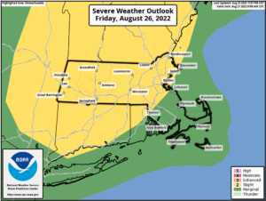
NWS ALERTS
–None, but isolated to scattered strong to severe thunderstorms may bring localized wind damage and/or street flooding. A secondary threat is a low chance of either larger hail or a weak tornado.
DHTWN REMINDER
–The odds of being a human is 1 in 400 trillion… make it count, even in a small way (see Kurt Vonnegut quote at end of post)
DAILY CELESTIAL (STAR):
–OUR STAR ROSE AT: 6:09am this morning
–OUR STAR WILL SET AT: 7:33pm this evening
–TOTAL DAYLIGHT TIME: 13 hours and 24 minutes
DAILY CELESTIAL (MOON):
–OUR MOON WILL SET AT: 7:43pm this evening
–OUR MOON WILL RISE AT: 6:10am tomorrow morning
–MOON SET DIRECTION: West-Northwest
–MOON RISE DIRECTION: East-Northeast
–MOON PHASE: New Moon 1.0%
———————-
DAILY TERRESTRIAL (ZoneCast)
ZONE 1 (Northern Region)
Southern VT, Southwest NH, N. Taconics NY
–High Temps: Upper 70s to Mid 80s
–Low Temps: Upper 50s to Low 60s
–Humidity: Dewpoints climbing into the mid to upper 60s by this afternoon, becoming more humid
–Wind: Light southerly wind may gust to 25mph at times
–Skies: Patchy fog early, then partly sunny skies early, with increasing clouds into the afternoon
–Precipitation: Isolated to scattered showers, downpours, and strong to severe thunderstorms for some this afternoon into possibly early evening
ZONE 2 (Central Region)
WMass, N. CMass, N. Litchfield County, C./S. Taconics NY
–High Temps: Low to Upper 80s
–Low Temps: Upper 50s to Mid 60s
–Humidity: Dewpoints climbing into the mid to upper 60s by this afternoon, becoming more humid
–Wind: Light southerly wind may gust to 25mph at times
–Skies: Patchy fog early, then partly sunny skies early, with increasing clouds into the afternoon
–Precipitation: Isolated to scattered showers, downpours, and strong to severe thunderstorms for some this afternoon into possibly early evening
ZONE 3 (Southern Region)
S. CMass, S. Litchfield County, NC.CT, & NE.CT
–High Temps: Low to Upper 80s
–Low Temps: Low to Mid 60s
–Humidity: Dewpoints climbing into the mid to upper 60s by this afternoon, becoming more humid
–Wind: Light southerly wind may gust to 25mph at times
–Skies: Patchy fog early, then partly sunny skies early, with increasing clouds into the afternoon
–Precipitation: Isolated to scattered showers, downpours, and strong to severe thunderstorms for some this afternoon into possibly early evening
———————-
WEATHER REPORT
Good morning everybody, I’m going to whip out my quiver of double–dashes this morning and liberally deliver them to your scanning eyeballs, which by the way, are the outward extension of your brain, did you know that? Your eyes are part of your brain.
#PrettyWildDude #Whoooaaaaaaa
LATE SUMMAH-RY
–We’ve got patchy dense fog out there in spots, but that will burn off this morning
–Any full sunshine goes to partial sunshine as the morning wears into the early afternoon and clouds build
–Highs will reach the upper 70s to upper 80s from north to south across the greater WMass region, which covers SVT/SWNH down to NCT and WMass/CMass in between
–A broad upper trough will be swinging through the northeast U.S. today
–At the surface, a stalled front will lift north as a warm front this morning, and we can’t rule out an isolated shower, but it should be mostly dry this morning
–Surface low pressure will be tracking east-northeast into northern New England today, dragging its cold front towards the WMass region this afternoon and evening
–Very warm and increasingly humid should be drawn north into our region, which will help support potential for heavy rainfall in any showers and thunderstorms that form today
–This will support southerly wind gusts of 15-25mph
–It should be noted that there will be some inhibiting factors to a more widespread severe weather event today (such as modest wind shear, poor mid-level lapse rates, and increasing cloud cover which should limit instability from maximizing)
–Given this, we should see scattered showers, downpours and thunderstorms form between 1-9pm today
–The main threat with any strong to severe thunderstorms is localized damaging straight line wind gusts, and/or areas of street flooding due to torrential rainfall
–Secondary, lower threats are that of larger hail and an isolated tornado (the latter being pretty unlikely, but the chance is still there)
–All activity dies down just after sunset, sooner west, later east
———————
LAST CALL TO WMASS REGIONAL PHOTOGRAPHERS FOR MY 2023 WEATHER WALL CALENDAR…My friend, if you’ve submitted in past years, or fancy yourself a fine photographer of the greater WMass region’s natural beauty (WMass, CMass, S.VT, SW.NH, or northern CT), please click the secure link to my website below to get the details on how you can be seen by over 1000 of your neighbors and be included in my 9th consecutive (and likely last) local/regional weather wall calendar.
The deadline for submission is 9/3/2022, and I really hope you’ll send some photos for consideration!
CLICK SECURE LINK!
———————
–Lows will drop into the upper 50s to mid 60s as we start to filter in some lower humidity and drier air
–For Saturday and Sunday, while an isolated afternoon pop-up shower could occur, thanks to incoming high pressure we should be mostly dry under mostly sunny skies with highs in the upper 70s to low 80s and lows either side of 60º
–Fair weather should continue into Monday as well, but we’ll start to heat up as high pressure passes south of us and pumps in southerly flow, which will increase our humidity as well
–Highs will climb into the 85-90º range Monday and Tuesday with lows in the 60s as humidity builds
–Another round of scattered showers and thunderstorms is expected sometime between the Tuesday night and Wednesday afternoon time frame with another cold frontal passage with highs in the 80s into mid-week
–By Thursday and late week, we will dry out and cool down into the mid to upper 70s as Canadian air pays us a visit with wonderfully low-humidity air
That’s it for now folks, stay tuned today as I will update again during the mid-day period regarding our potential severe weather today.
I hope you have a great day!
Did you know that you can also follow me on Twitter?
AND REMEMBER…
“Hello babies. Welcome to Earth. It’s hot in the summer and cold in the winter. It’s round and wet and crowded. On the outside, babies, you’ve got a hundred years here. There’s only one rule that I know of, babies: Goddamn it, you’ve got to be kind.”
–Kurt Vonnegut