
>>> YOUR DAILY CELESTIALS <<<
STAR:
–OUR STAR ROSE AT: 6:07am this morning
–OUR STAR WILL SET AT: 7:37pm this evening
–TOTAL DAYLIGHT TIME: 13 hours and 30 minutes
MOON:
–OUR MOON WILL SET AT: 11:28pm tonight
–MOON SET DIRECTION: Southwest
–OUR MOON WILL RISE AT 3:41pm tomorrow afternoon
–MOON RISE DIRECTION: Southeast
–MOON PHASE: Waxing Gibbous (50.7%)
~~~~~~~~~~~~~~~~~~~~~~
>>> DAVE’S WEEKLY WEATHER NUTSHELL <<<
–Clouds increase from west to east after morning sunshine, that may linger in CMass/northeast CT into afternoon
–Showers arrive at night, lasting into Friday morning when some thunderstorms may roll through, and a couple may be potent
–More showers redevelop Friday afternoon as a warm front works through
–Cool temps next couple of days with highs either side of 70º
–Some scattered showers, but conditions should be improving with a cold frontal passage
–Drier Saturday night into Sunday with warmer temps well into the 70s and more sunshine, which lasts into Monday
–By Tuesday into Wednesday, we could be dealing with heavy rainfall well northwest of but still connected to Tropical Storm Franklin and potentially fueled by tropical Gulf of Mexico activity, but before we talk details let’s check a note from our local and delicious sponsor, #TandemBagelCo, with their newest location in the Stop & Shop Plaza on King Street in Northampton, MA.
~~~~~~~~~~~~~~~~~~~~~~
>>> A NOTE FROM OUR SPONSOR <<<
Dave Hayes The Weather Nut is Sponsored by Individual Community Members, Patrons & Tandem Bagel Company… No matter the weather, Tandem Bagel is always there for you at several valley locations to make your mornings brighter! With bagels baked fresh daily (including Gluten-Free options), house-whipped cream cheese, coffee, and tons of lunch options, Tandem is the perfect quick stop for lunch, breakfast, or a coffee and bagel to go. Find them in Easthampton, Northampton, Hadley, Florence, and West Springfield, or use their super-streamlined online ordering tool by visiting their website.
>>> MORNING DISCUSSION <<<
Good morning everybody, just as a reminder, we’re still here, we’re still hurtling through the cosmos at 500000mph, most of us are still able to raise our eyebrows, and if we can still boil a pot of rice and open a can of beans and have access to some salt, and a few vegetables, then that’s something for which to be grateful.
I am fortunate enough to make some pesto later today, and will proceed to take the submarine-sized zucchinis we grew and turn them into Stuffed Zuke Boats (SZBs) for this evening, so the day’s a win for this writer out of the gate.
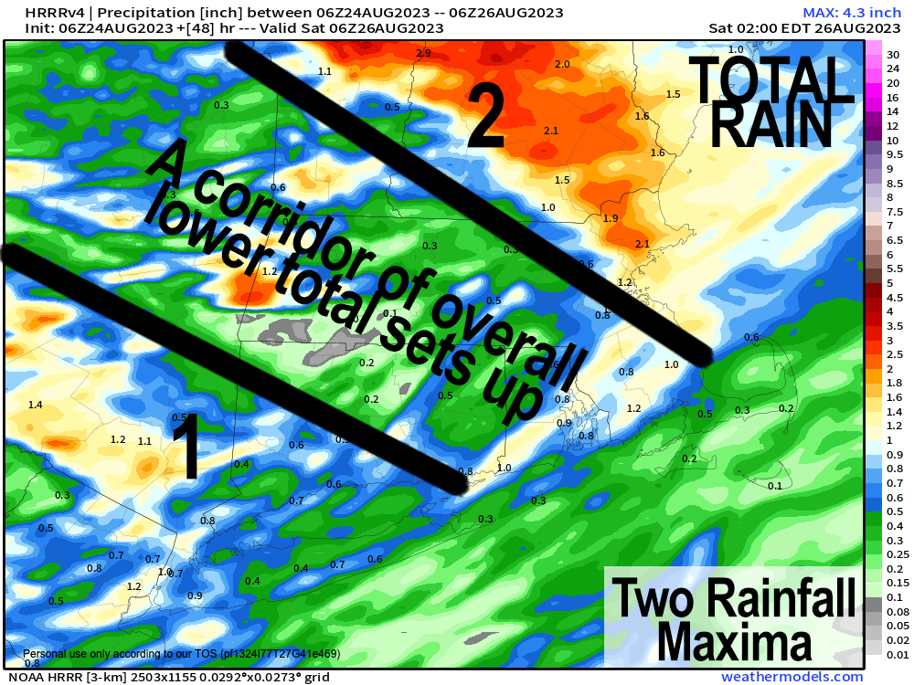
As for our weather, we have a couple of notable wet weather periods upcoming, and the first one is tonight into Friday and tapering through Friday night into Saturday morning.
High pressure to our east lingers and told me that it’s unwilling to leave just yet, and I told it “that’s cool, you have until today, but really, it’s time to move along” and it told me “ok buddy, I hear ya, thanks for giving me a few extra hours near Boston, you’re a good egg” and I said “I am NOT a good egg, I am a person, BUT I do make good eggs” and I proceeded to make like 15 frittatas, so you’re all invited for brunch!
Because said high pressure is slow to leave, it will remain drier for longer today, and sunnier east of the I-91 corridor, because clouds are already slowly creeping east into the greater WMass region.
Highs will be in the upper 60s to low 70s today, and by tonight, we’ll see scattered showers working into the region ahead of a warm frontal passage slated for tomorrow. Lows tonight will drop into the upper 50s to low 60s.
A cluster of thunderstorms may contain a few strong cells early Friday morning, so some of us could be rocking and rolling for morning commute.
Highs again Friday will only be in the upper 60s to low 70s, and we’ll have waves of scattered showers during the day, with heaviest rainfall likely in southwest MA and western CT, and even heavier rainfall well northeast of our region.
After some scattered showers Friday evening into Saturday morning, we should have a cold front swing through the region and knock humidity down for Sunday into Monday, though dewpoints should generally be in the low 60s, which is a bit muggy.
Saturday should feature improving weather with at least partial sunshine by afternoon with highs in the 70s, and Sunday is definitely the pick of the week with mostly sunny skies and highs also in the 70s — condition that should last into Monday well.
By Tuesday, we have to watch how a few tropical systems interact, their exact tracks, and how much moisture from these systems feeds up into New England, but for now, Tuesday night into Wednesday looks quite rainy, and has the potential for flash flooding, so stay tuned for future updates.
Behind Tropical Storm Franklin’s departure through and away to the east of/from Cape Breton, Nova Scotia, much drier air looks to get yanked into our region for late next week, so our autumnal tastes continue to be dropped onto our collective regional tongue, and this writer is looking forward to such seasonal seasonings.
Have a great day!
>>> BE KIND <<<
“Hello babies. Welcome to Earth. It’s hot in the summer and cold in the winter. It’s round and wet and crowded. On the outside, babies, you’ve got a hundred years here. There’s only one rule that I know of, babies: Goddamn it, you’ve got to be kind.”
–Kurt Vonnegut