
Good morning folks, some of us got a lot of rain yesterday (check the rain totals map attached), but again some got very little, as is the case with summertime convection patterns. There was one strong to severe storm that formed out of the Southampton / Holyoke area and lifted northeast into South Hadley and Belchertown with outages down that way, and some tree damage. There was a second that caused flash flooding issues in northern CT. Otherwise, any storms mostly just gushed rain and thunder-rattled houses, and also caused some street flooding where heavy rain overwhelmed the ability of some drains to remove water fast enough.
Going forward, we have decreasing clouds and fog today and isolated shower possible, followed by increasingly sunny conditions into Friday, the potential for strong to severe storms Friday afternoon with a strong cold front, a very warm and mostly fair weekend with increased heat and humidity early next week, along with more strong storms possible Tuesday before we cool things down, but before we dive into all of the weather details below, let’s check a note from our local and delicious sponsor, #TandemBagelCo, with their newest location in West Springfield, MA.
——————–
A NOTE FROM OUR SPONSOR:
DHTWN Is Sponsored by Members, Patrons & Tandem Bagel Company: No matter the weather, Tandem Bagel is always there for you at several valley locations to make your mornings brighter! With bagels baked fresh daily, house-whipped cream cheese, coffee, and tons of lunch options, Tandem is the perfect quick stop for lunch, breakfast, or a coffee and bagel to go. Find them in Easthampton, Northampton, Hadley, Florence (and now West Springfield!), or use their super-streamlined online ordering tool by visiting their website: https://www.tandembagelco.com
——————————————-
***DHTWN DAILY WEATHER REPORT***
——————————————-
NWS ALERTS
–None
DHTWN REMINDER
–The odds of being a human is 1 in 400 trillion… make it count, even in a small way (see Kurt Vonnegut quote at end of post)
DAILY CELESTIAL (STAR):
–OUR STAR ROSE AT: 6:07am this morning
–OUR STAR WILL SET AT: 7:37pm this evening
–TOTAL DAYLIGHT TIME: 13 hours and 30 minutes
DAILY CELESTIAL (MOON):
–OUR MOON WILL SET AT: 6:44pm this evening
–OUR MOON WILL RISE AT: 4:01am tomorrow morning
–MOON SET DIRECTION: West-Northwest
–MOON RISE DIRECTION: East-Northeast
–MOON PHASE: Waning Crescent 7.9%
———————-
DAILY TERRESTRIAL (ZoneCast)
ZONE 1 (Northern Region)
Southern VT, Southwest NH, N. Taconics NY
–High Temps: Upper 70s to Low 80s
–Low Temps: Upper 50s to Low 60s
–Humidity: Dewpoints in the 60s, fairly humid
–Wind: Light northwesterly wind
–Skies: Cloudy with patchy fog early, then decreasing clouds and developing sunshine
–Precipitation: Isolated showers possible later
ZONE 2 (Central Region)
WMass, N. CMass, N. Litchfield County, C./S. Taconics NY
–High Temps: Low to Mid 80s
–Low Temps: Mid 50s to Low 60s
–Humidity: Dewpoints in the 60s, fairly humid
–Wind: Light northwesterly wind
–Skies: Cloudy with patchy fog early, then decreasing clouds and developing sunshine
–Precipitation: Isolated showers possible later
ZONE 3 (Southern Region)
S. CMass, S. Litchfield County, NC.CT, & NE.CT
–High Temps: Low to Mid 80s, some upper 80s possible
–Low Temps: Low to Mid 60s
–Humidity: Dewpoints in the 60s, fairly humid
–Wind: Light northwesterly wind
–Skies: Cloudy with patchy fog early, then decreasing clouds and developing sunshine
–Precipitation: Isolated showers possible later
———————-
WEATHER REPORT
Good morning everybody, after the downpours, showers, and thunderstorms that some of us dealt with yesterday, we’ve got a much less active period of weather coming up today through the first half of Friday.
We’ll have light northwest flow behind the frontal passage last night, and clouds will decrease with time pushing highs into the upper 70s to mid 80s across the greater WMass region with an isolated shower possible at some point this afternoon in any bubbling cumulus clouds.
For tonight, it will be fairly crisp with tolerable humidity and lows in the upper 50s to mid 60s under mostly clear skies as high pressure builds in from the west.
Thursday is looking gorgeous after some patchy fog in the morning, with sunshine and highs in the low to mid 80s, and lows in the upper 50s to low 60s.
Friday is going to be a changeable day as there is already a marginal threat in place for the potential for severe thunderstorms (meaning we may see an isolated one or two storms that could produce large hail and/or damaging wind gusts).
It should start off sunny, but clouds will build as a cold front approaches the region by afternoon, with scattered showers and storms expected by mid afternoon to early evening, but I will refine that as we get closer.
———————
LAST CALL TO WMASS REGIONAL PHOTOGRAPHERS FOR MY 2023 WEATHER WALL CALENDAR…My friend, if you’ve submitted in past years, or fancy yourself a fine photographer of the greater WMass region’s natural beauty (WMass, CMass, S.VT, SW.NH, or northern CT), please click the secure link to my website below to get the details on how you can be seen by over 1000 of your neighbors and be included in my 9th consecutive (and likely last) local/regional weather wall calendar.
The deadline for submission is 9/3/2022, and I really hope you’ll send some photos for consideration!
CLICK SECURE LINK
———————
Highs Friday will be well into the 80s with lows near 60º.
High pressure builds in behind the front over the weekend with mostly sunny skies expected and highs in the low to mid 80s with lows in the upper 50s to low 60s.
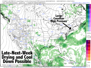
By early next week (Monday and Tuesday) we should warm right up and see a surge in higher humidity with highs in the upper 80s to low 90s ahead of a cold front that looks to move through on Tuesday.
This frontal passage should not only produce strong to possibly severe thunderstorms in a few spots, but it should help to usher in at least a temporary pattern change with cooler temps in the 70s for highs late next week and much lower humidity.
While yesterday’s rain was good for some drought mitigation where it did fall, there were plenty of folks who saw very little rain, too, so at this point we’re going to need the remnants of a tropical storm or three to drop rain across the region, or we’ll need an early transition into Autumn and get some rainy nor’easters in here, because summer convection patterns rarely mitigate drought.
That does it for now, my friends, I hope you have a great day!
Did you know that you can also follow me on Twitter?
AND REMEMBER…
“Hello babies. Welcome to Earth. It’s hot in the summer and cold in the winter. It’s round and wet and crowded. On the outside, babies, you’ve got a hundred years here. There’s only one rule that I know of, babies: Goddamn it, you’ve got to be kind.”
–Kurt Vonnegut