
TABLE OF CONTENTS
* Daily Celestials (Sun/Moon Data)
* Sponsor Note
* Join My Newsletter
(& get my Top12WMassStorms ebook!)
* Morning Discussion
* TIP: Scroll below for sections, or read all
~~~~~~~~~~~~~~~~~~~~~~
YOUR DAILY CELESTIALS
~~~~~~~~~~~~~~~~~~~~~~
STAR:
–OUR STAR ROSE AT: 6:07am this morning
–OUR STAR WILL SET AT: 7:37pm this evening
–TOTAL DAYLIGHT TIME: 13 hours and 30 minutes
MOON:
–OUR MOON WILL RISE AT: 9:41pm this evening
–MOON RISE DIRECTION: East-Northeast
–OUR MOON WILL SET AT: 12:06pm tomorrow afternoon
–MOON SET DIRECTION: West-Northwest
–MOON PHASE: Waning Gibbous (81.3%)
~~~~~~~~~~~~~~~~~~~~~~
A NOTE FROM OUR SPONSOR
~~~~~~~~~~~~~~~~~~~~~~
Dave Hayes The Weather Nut is Sponsored by Individual Community Members, Patrons, and Tandem Bagel Company… No matter the weather, Tandem Bagel is always there for you at several valley locations to make your mornings brighter! With *New Pizza Bagels(!)*, along with bagels baked fresh daily (including Gluten-Free options), house-whipped cream cheese, coffee, and tons of lunch options, Tandem is the perfect quick stop for lunch, breakfast, or a coffee and bagel to go.
You can either 1) visit them in Easthampton, Northampton, Hadley, Florence, and/or West Springfield, 2) hire them to cater your next event, or 3) use their super-streamlined online ordering tool by visiting their website and clicking the “Catering” or “Order Online” links.
~~~~~~~~~~~~~~~~~~~~~~
DAVE’S WEEKLY NEWSLETTER (Top 12 WMass Storms)
DAVE’S MOBILE APP (Late 2024 Release)
~~~~~~~~~~~~~~~~~~~~~~
YOUR MORNING DISCUSSION
~~~~~~~~~~~~~~~~~~~~~~
Good morning peeps, the post-6am sunrises and soon to be experienced sub-7:30pm sunsets are already getting my attention, as August is the month when the light really starts to vacate the premises.
Regardless of the lessening light, we do have increasing sunshine today through Sunday afternoon, after which we’ll see an upper trough start to bring more clouds, humidity, moisture and unsettled conditions our way by very late this weekend through about the middle of next week.
For today and tomorrow, mostly sunny skies are expected with highs in the mid to upper 70s today, and upper 70s to low 80s Saturday, with lows in the low to mid 50s tonight and mid to upper 50s tomorrow night under clear skies with light wind, though could be a bit breezy by this afternoon.
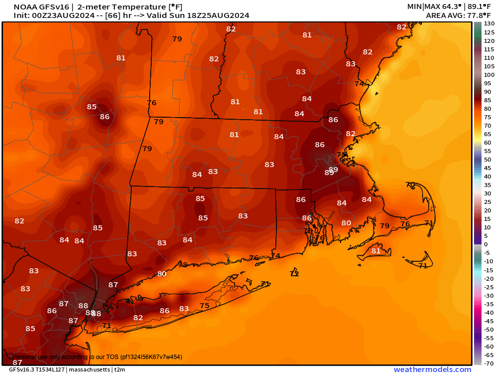
On Sunday, we warm up into the low to mid 80s as high pressure passes south of us, with a sunny start.
However, as an upper trough starts to approach the region, and as humidity starts to increase later on Sunday, we could see some isolated showers or thunderstorms form by later afternoon or at night as lows hang near 60º.
By early to mid week, we should see more humid conditions and periods of showers and thunderstorms, especially on Monday, possibly lasting into Tuesday with highs in thee 75-80º range.
Thereafter, we could also see some heat surging into the region with Thursday looking like it could still hit 90º.
By late week, a potent storm system will be winding up in southern Canada, and depending on its track and speed, we could see a cold front trying to swing showers and thunderstorms into the greater WMass region by Friday or Saturday, with a cool down behind it.
However, we could also see this front sort of stall out over our region, causing showers/storms to persist, so I will keep updating as we get closer.
For now, enjoy this lovely weather and have a great day!
“Follow your bliss and the universe will open doors for you where there were only walls.”
― Joseph Campbell