
Good morning folks, there’s a bit of patchy fog in spots this morning, otherwise we’re mostly cloudy with a few isolated showers in a few locations.
To summarize, we’re expecting an overcast day with scattered afternoon showers, downpours and storms that will last into the evening as a warm front passes through, followed by scattered showers/storms Tuesday, very warm but dry conditions on Wednesday and Thursday, and more showers/storms possible for Friday prior to what could be a drier, nicer weekend, but before we dive into all of the weather details below, let’s check a note from our local and delicious sponsor, #TandemBagelCo, with their newest location in West Springfield, MA.
——————–
A NOTE FROM OUR SPONSOR:
DHTWN Is Sponsored by Members, Patrons & Tandem Bagel Company: No matter the weather, Tandem Bagel is always there for you at several valley locations to make your mornings brighter! With bagels baked fresh daily, house-whipped cream cheese, coffee, and tons of lunch options, Tandem is the perfect quick stop for lunch, breakfast, or a coffee and bagel to go. Find them in Easthampton, Northampton, Hadley, Florence (and now West Springfield!), or use their super-streamlined online ordering tool by visiting their website: https://www.tandembagelco.com
——————————————-
***DHTWN DAILY WEATHER REPORT***
——————————————-
NWS ALERTS
–None
DHTWN REMINDER
–The odds of being a human is 1 in 400 trillion… make it count, even in a small way (see Kurt Vonnegut quote at end of post)
DAILY CELESTIAL (STAR):
–OUR STAR ROSE AT: 6:05am this morning
–OUR STAR WILL SET AT: 7:40pm this evening
–TOTAL DAYLIGHT TIME: 13 hours and 35 minutes
DAILY CELESTIAL (MOON):
–OUR MOON WILL SET AT: 5:21pm this afternoon
–OUR MOON WILL RISE AT: 2:01am tonight
–MOON SET DIRECTION: Northwest
–MOON RISE DIRECTION: Northeast
–MOON PHASE: Waning Crescent 21.1%
———————-
DAILY TERRESTRIAL (ZoneCast)
ZONE 1 (Northern Region)
Southern VT, Southwest NH, N. Taconics NY
–High Temps: Mid to Upper 70s
–Low Temps: Low to Mid 60s
–Humidity: Dewpoints well into the 60s to near 70º, muggy
–Wind: Light southeast wind
–Skies: Mostly Cloudy
–Precipitation: Scattered showers, downpours and t-storms, mainly in the afternoon and evening, and especially east of the CT River in Cheshire County NH
ZONE 2 (Central Region)
WMass, N. CMass, N. Litchfield County, C./S. Taconics NY
–High Temps: Mid to Upper 70s
–Low Temps: Low to Mid 60s
–Humidity: Dewpoints well into the 60s to near 70º, muggy
–Wind: Light southeast wind
–Skies: Mostly Cloudy
–Precipitation: Scattered showers, downpours and t-storms, mainly in the afternoon and evening, and with the heaviest rain potential east of the CT River
ZONE 3 (Southern Region)
S. CMass, S. Litchfield County, NC.CT, & NE.CT
–High Temps: Mid to Upper 70s
–Low Temps: Mid to Upper 60s
–Humidity: Dewpoints well into the 60s to near 70º, muggy
–Wind: Light southeast wind
–Skies: Mostly Cloudy
–Precipitation: Scattered showers, downpours and t-storms, mainly in the afternoon and evening, and with the heaviest rain potential east of the CT River
———————-
WEATHER REPORT
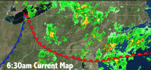
Good morning everybody, I hope things go your way today, and I hope that many of us get a good soaking rainfall today, too.
We have a warm frontal boundary down across the Mid-Atlantic region which will be pushing north and northeast today.
While we’ll see a few isolated to scattered showers this morning, but the bulk of the activity will come during the afternoon, especially towards mid to late afternoon.
Highs will be in the mid to upper 70s with a light southeast wind, and skies will generally be overcast, along with a sticky/muggy feel.
Some showers may produce downpours given how much moisture will be working through the region, but again, some folks won’t see a lot of rain today, as we’ll see clusters of showers and storms with this warm front, not a widespread stratiform rainstorm like a nor’easter (though I’d love to be wrong about this, and get a rain shield to form! Trying to work some reverse psychology on Mutha Nayctha!).
For tonight, additional scattered showers are expected with patchy fog late and lows in the 60s with humid conditions continuing, and even increasing by morning behind the warm front.
On Tuesday, a cold front will be moving through the region in the evening, and so ahead of it we will see some more scattered showers and a few non-severe thunderstorms, but coverage will be overall less than today.
Highs will reach the mid 70s to low 80s, and despite mostly cloudy skies, a few sunny breaks are possible, and it will be quite muggy.
Any shower or storm activity ends before midnight, with lows in the low to mid 60s.
———————
LAST CALL TO WMASS REGIONAL PHOTOGRAPHERS FOR MY 2023 WEATHER WALL CALENDAR…My friend, if you’ve submitted in past years, or fancy yourself a fine photographer of the greater WMass region’s natural beauty (WMass, CMass, S.VT, SW.NH, or northern CT), please click the secure link to my website below to get the details on how you can be seen by over 1000 of your neighbors and be included in my 9th consecutive (and likely last) local/regional weather wall calendar.
The deadline for submission is 9/3/2022, and I really hope you’ll send some photos for consideration!
CLICK SECURE LINK!
———————
By Wednesday, we should be behind (i.e. west of) the cold front to our east, which should allow for mostly sunny skies to develop after any morning fog burns off, with highs in the upper 70s to mid 80s and a spot shower possible in the afternoon.
Lows will drop to the upper 50s to low 60s.
Thursday looks like the pick of the week with sunny skies, very warm temps in the mid to upper 80s, and dry conditions. Lows will drop to either side of 60º.
By Friday, another frontal boundary will likely be pushing into the region with some afternoon showers or storms possible and highs well into the 80s with lows in the 55-60º range.
The weekend looks warm and mostly sunny at the moment as high pressure tries to move in from our west with moderate humidity, and highs in the 80s with lows in the low to mid 60s.
That does it for now, my friends, I hope you have a great day!
Remember that you can also follow me on Twitter.
AND REMEMBER…
“Hello babies. Welcome to Earth. It’s hot in the summer and cold in the winter. It’s round and wet and crowded. On the outside, babies, you’ve got a hundred years here. There’s only one rule that I know of, babies: Goddamn it, you’ve got to be kind.”
–Kurt Vonnegut