
Good morning folks, there’s more numerous fog patches out in the greater WMass region this morning, with Worcester notably at under a quarter mile visibility with very dense fog.
We’ll see these fog patches burn off with time and reveal a mostly sunny day with highs again in the mid 80s to low 90s with dewpoints in the 60s for a muggy feel to be followed by what may be a solid drink of rain Monday morning into the afternoon along with some scattered showers and storms Tuesday with a warm, humid and dry finish to the upcoming work week, but before we dive into all of the weather details below, let’s check a note from our local weekend sponsor, #YankeeMattressFactory, with their main headquarters in Agawam, MA along with stores located around the valley.
——————–
A NOTE FROM OUR WEEKEND SPONSOR:
DHTWN is sponsored by members, patrons, and Yankee Mattress Factory. Yankee Mattress is employee-owned, and mattresses are handmade locally in Agawam, MA. Several years ago I purchased a Yankee mattress and was very pleased with their quality and the buying experience, which was friendly and low pressure. Starting on September 1st and running through October 31st, Yankee Mattress will be partnering with the American Cancer Society to raise money to support breast cancer research and local services. A portion of each mattress sale will go towards their goal of donating $10,000 towards this cause. Visit the Yankee Mattress store closest to you in Agawam, Springfield, Northampton, or Greenfield, or click for more info.
——————————————-
***DHTWN DAILY WEATHER REPORT***
——————————————-
Good morning everybody, we’ve got another summery day ahead after we get some of these fog patches burned off.
Temps are in the 60s and so are our dew point temps, so the air is saturated in a number of spots, hence the fog and/or low clouds.
As the morning wears on, we should see the August sun angle go to work and combine with high pressure to our southeast to produce a mostly sunny day with southerly breezes and highs in the 85-90º range with a few low 80s in the mountains of SVT and some low 90s readings in the southern valley. It will be humid as well, but not oppressively so.
For tonight, humidity continues with lows in the low to mid 60s along with clouds increasing, with a few showers possible by the early morning timeframe.
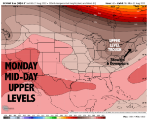
However, as the warm frontal boundary approaches the region later Monday morning, we will hopefully see a fairly large and somewhat cohesive cluster of showers, downpours and even a few thunderstorms tracking northeast through the WMass region by mid to late morning, and lasting well into the afternoon before things lighten up late afternoon into early evening.
Highs tomorrow will only reach the mid to upper 70s with cloudy skies, and lows tomorrow night will dip into the low to mid 60s with scattered showers or a thunderstorm possible, along with patchy fog late.
———————
LAST CALL TO WMASS REGIONAL PHOTOGRAPHERS FOR MY 2023 WEATHER WALL CALENDAR…My friend, if you’ve submitted in past years, or fancy yourself a fine photographer of the greater WMass region’s natural beauty (WMass, CMass, S.VT, SW.NH, or northern CT), please click the secure link to my website below to get the details on how you can be seen by over 1000 of your neighbors and be included in my 9th consecutive (and likely last) local/regional weather wall calendar.
The deadline for submission is 9/3/2022, and I really hope you’ll send some photos for consideration!
CLICK SECURE LINK BELOW:
———————
By Tuesday, the warm front will be well northeast of us, but a cold front will still be to our west.
This means that we will likely see some scattered showers or thunderstorms in the morning and into the afternoon.
Exactly when the front comes through will help determine when we will start drying things out, so I will have to update you on that piece as we get closer.
Highs will reach the upper 70s to low 80s Tuesday with lows in the 60s as showers quit.
The Wednesday through Saturday period looks like another 4-day stretch of fair weather with pretty humid conditions, mostly sunny skies, and highs well into the 80s for highs with a few low 90s readings possible, along with lows in the low to mid 60s.
Let’s hope Monday and Monday night really delivers the rainfall, as it is our best chance that I’ve seen with 24 hours to go in a while.
After that, we’re dry again and unfortunately, the only real shot at drought-denting rains going forward is going to be the remnants of a tropical system, or a direct hit of a tropical system.
I do not wish for the latter, ever, but do hope for the former so we can start to turn things around in southern New England in terms of the drought, which has reached severe levels in most areas of our region.
Here’s hoping for a Fall filled with rainy nor’easters!
Have a great day and remember that you can also follow me on Twitter: https://twitter.com/DHTheWeatherNut
WELCOME TO EARTH, BABIES…
“Hello babies. Welcome to Earth. It’s hot in the summer and cold in the winter. It’s round and wet and crowded. On the outside, babies, you’ve got a hundred years here. There’s only one rule that I know of, babies: Goddamn it, you’ve got to be kind.”
–Kurt Vonnegut