
>>> YOUR DAILY CELESTIALS <<<
STAR:
–OUR STAR ROSE AT: 6:03am this morning
–OUR STAR WILL SET AT: 7:43pm this evening
–TOTAL DAYLIGHT TIME: 13 hours and 40 minutes
MOON:
–OUR MOON WILL SET AT: 9:39pm tonight
–MOON SET DIRECTION: West
–OUR MOON WILL RISE AT: 11:04am tomorrow morning
–MOON RISE DIRECTION: East-Southeast
–MOON PHASE: Waxing Crescent (14.6%)
~~~~~~~~~~~~~~~~~~~~~~
>>> DAVE’S WEEKLY WEATHER NUTSHELL <<<
–Mostly sunny today with some high clouds, as well as some smoke/haze (Air Quality Alerts not expected)
–Very warm, highs low to mid 80s, fairly comfy humidity
–Excellent sunset potential tonight, post pics later!
–Lows low to mid 60s partly cloudy
–Humid Monday, dewpoints 65-70º, highs low to mid 80s
–Clouds increase in the afternoon with a few showers or a thunderstorm, no big deal
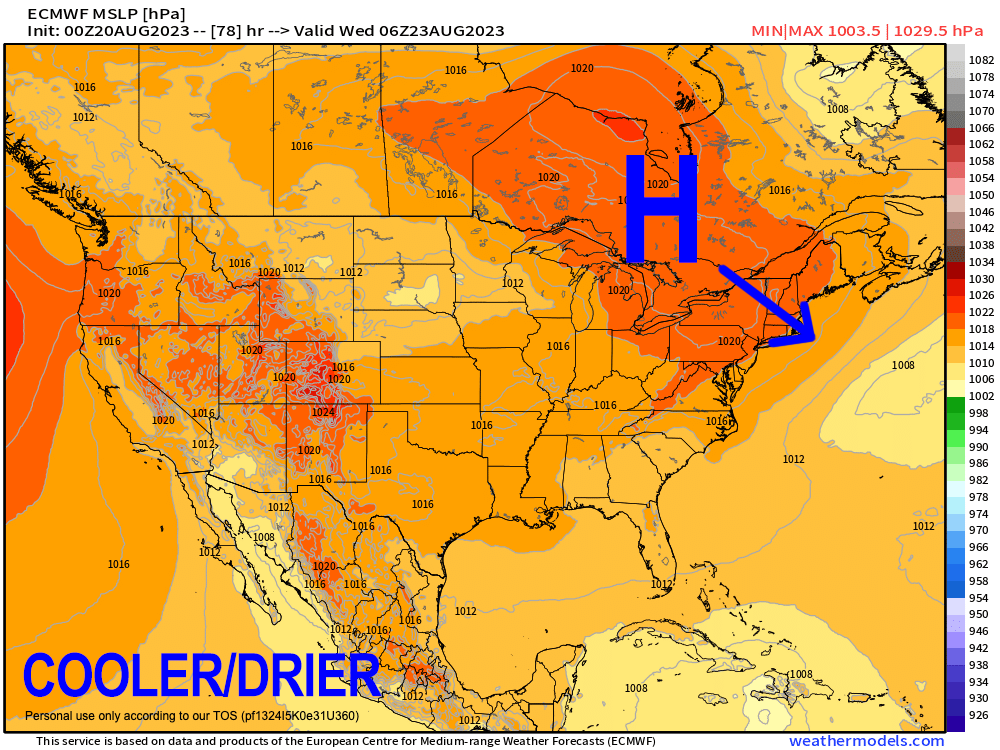
–The Whooshening commences Monday night through Thursday night with a much drier, and cooler air mass
–Highs reach the 70s, lows in the 50s, fair weather expected for now
–Humidity returns Friday, with showers and thunderstorms arriving Friday night into the weekend, which may be mostly inclement with heavy rain possible, but before we get into this afternoon’s severe weather details let’s check a note from our local weekend sponsor, #GerardGhazeyBatesPC, an estate planning law firm in Northampton, MA.
~~~~~~~~~~~~~~~~~~~~~~
>>> A NOTE FROM OUR SPONSOR <<<
Dave Hayes The Weather Nut is Sponsored by Individual Community Members, Patrons & Gerard, Ghazey & Bates, P.C. GGBPC is a Northampton-based law firm regarded as the voice of pragmatic and well-reasoned estate planning, elder law and tax guidance in Western Massachusetts. The firm specializes in estate planning law, and expertly handles other matters such as Elder Law, Tax Law, as well as Real Estate purchase, sales, and refinance transactions. Click to Contact GGBPC today to see how they can help!
>>> MORNING DISCUSSION <<<
Good morning everybody, we’ve got a lot of mostly fair weather ahead between now and Friday noon before our weather takes a turn toward inclemency once again, but let us enjoy the dryness, calmness and overall peacefulness between now and then.
For today, we do have some wildfire smoke from western Canada working through the region, and while there may be some modest compromises in air quality, it should reach the level of triggering an Air Quality Alert, and hopefully will remain mostly aloft, producing a haze in the sky.
We should see a mostly sunny day with some high clouds, and highs in the low to mid 80s with solid sunset chances, so please post pics later!
As it turns out, I am rehearsing from 2pm-10pm today given that I’m in 5 acts this year for Performance 33 at the Pines Theatre in Look Park, Florence, MA Tuesday 4-9:30pm.
The weather is looking AMAZING, so I hope you’ll come for a fun, inexpensive night out (only $13 a ticket for 5 hours of music!), and support the local arts.
Lows tonight will drop into the low to mid 60s as humidity starts to creep up, and by tomorrow it will be quite humid with dewpoints in the mid to upper 60s under partly sunny skies, with clouds building in the afternoon.
We’ll have upper level high pressure to our west, and upper level low pressure to our east, and a wave associated with that upper low will slide southeast along its western flank and through northern and eastern New England, swiping us with some showers and a thunderstorm or two.
Given westerly flow (wind blowing TO the east), and the front tracking southeast, there isn’t a lot of convergence, or wind pushing into itself to cause rising air motion, so serious weather is not expected, plus moisture will be limited.
So, a few showers and a storm or two tomorrow late afternoon and evening, and then a reinforcing shot of cooler/drier air will unleash The Whooshening into our region with three days/nights of expected low-humidity, fair and dry weather with highs in the 70s, lows in the 50s, and no rain Tuesday through Thursday.
By Friday, humidity increases as southwest flow gets re-established with a frontal boundary tracking east toward our region, along with the potential for coastal low pressure to develop south of us, and combine with this front to produce rain, heavy at times Friday night into Saturday, with a few leftover showers possible on Sunday.
We’re going to love this coastal low because it also likely pushes a hurricane in the Atlantic out to sea and away from us.
We have had a combo of higher wind shear and Saharan dust over the Atlantic tropical region, but with time, we are entering the busier part of the Atlantic hurricane season and the water is VERY warm, so I will be monitoring this closely as we push into September and potential impacts on New England.
For now, have a great day!
>>> BE KIND <<<
“Hello babies. Welcome to Earth. It’s hot in the summer and cold in the winter. It’s round and wet and crowded. On the outside, babies, you’ve got a hundred years here. There’s only one rule that I know of, babies: Goddamn it, you’ve got to be kind.”
–Kurt Vonnegut