
Good morning folks, we’ve got a bit of light fog in spots this morning, with areas of mid to high cloudiness and partial sunshine and temps in the upper 50s to 60s.
To summarize, we’re expecting very warm to hot summer weekend with temps peaking today along with an isolated shower or thunderstorm followed by more in the way of scattered showers, downpours and storms late Sunday night through Monday and into Tuesday before we dry things out mid to late week with continued humid conditions, but before we dive into all of the weather details below, let’s check a note from our local weekend sponsor, #YankeeMattressFactory, with their main headquarters in Agawam, MA along with stores located around the valley.
——————–
A NOTE FROM OUR WEEKEND SPONSOR:
DHTWN is sponsored by members, patrons, and Yankee Mattress Factory. Yankee Mattress is employee-owned, and mattresses are handmade locally in Agawam, MA. Several years ago I purchased a Yankee mattress and was very pleased with their quality and the buying experience, which was friendly and low pressure. Starting on September 1st and running through October 31st, Yankee Mattress will be partnering with the American Cancer Society to raise money to support breast cancer research and local services. A portion of each mattress sale will go towards their goal of donating $10,000 towards this cause. Visit the Yankee Mattress store closest to you in Agawam, Springfield, Northampton, or Greenfield, or click for more info: https://yankeemattressfactory.com/
——————————————-
***DHTWN DAILY WEATHER REPORT***
——————————————-
Good morning fine folks, I generally look at everything in life as having pros and cons. Obviously, the pattern we’re in has the con of creating a severe to extreme drought, which is very bad on many levels. The pro of it, though, is that we haven’t had much severe weather to speak of this year as compared to the previous several years, most notably the Summer of 2018 (when I almost pulled my hair out, though nature and my lack of hormonal balance has done most of that work for me already, ba dum crash, I’ll be here all week).
I bring that up to say that while we have a chance at a few strong thunderstorms Monday and/or Tuesday, we’re looking fairly storm-free and absent of severe weather through next week.
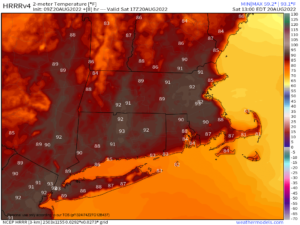
For today, after any morning fog burns off we should end up with a partly to mostly sunny day with very warm to hot temps reaching the mid 80s to low 90s. Isolated showers, downpours or thunderstorms are possible in the afternoon, so while most stay dry, don’t be surprised if you get wet.
For tonight, any shower activity quits with the earlier-and-earlier setting Sun. Lows will bottom out in the upper 50s to low 60s and patchy fog is possible late at night.
For Sunday, another very warm day arrives, but with more clouds around it will be a smidge cooler with highs in the mid to upper 80s, with some 90º spots.
Southerly winds will be light this weekend, and clouds will build Sunday night with lows in the low to mid 60s as humidity continues to increase with a warm frontal boundary floating towards the New England region.
By very early Monday morning, we should see a cluster of showers and thunderstorms track into parts of the greater WMass region, and it could rain hard in a couple of spots.
So, Monday looks mostly cloudy, and cooler with highs in the mid to upper 70s with scattered showers possible with and behind the warm frontal passage. Lows will drop into the low to mid 60s and we still expect scattered showers in the humid pre-frontal trough environment.
On Tuesday, our upper level trough will be pressing into the eastern Great Lakes and northwestern New England, with a surface low dragging its cold front towards the region.
This will help produce more scattered showers and thunderstorms, but the big question is when does the activity scoot east of the region?
Right now, it looks like it could last into the late afternoon, and possibly as late as the early evening, but since this write is performing at Look Park Tuesday evening, I will be doing my best to conjure my best Gandalf The Gray to part the skies, and help the show go on!
Highs Tuesday will reach the upper 70s to low 80s and lows will bottom out in the low 60s as we begin drying up.
Wednesday through Friday still look humid with zonal flow in place, and no secondary Canadian cold fronts to change out the air mass, but we also look to be under the influence of high pressure with mostly sunny skies and highs in the 80s through the period with lows in the 60s.
That’s it for now, I hope you have a great day!
Remember that you can also follow me on Twitter
AND REMEMBER…
“Hello babies. Welcome to Earth. It’s hot in the summer and cold in the winter. It’s round and wet and crowded. On the outside, babies, you’ve got a hundred years here. There’s only one rule that I know of, babies: Goddamn it, you’ve got to be kind.”
–Kurt Vonnegut