
>>> YOUR DAILY CELESTIALS <<<
STAR:
–OUR STAR ROSE AT: 6:01am this morning
–OUR STAR WILL SET AT: 7:46pm this evening
–TOTAL DAYLIGHT TIME: 13 hours and 46 minutes
MOON:
–OUR MOON WILL SET AT: 9:02pm this evening
–MOON SET DIRECTION: West
–OUR MOON WILL RISE AT 8:59am tomorrow morning
–MOON RISE DIRECTION: East
–MOON PHASE: Waxing Crescent (3.8%)
~~~~~~~~~~~~~~~~~~~~~~
>>> DAVE’S WEEKLY WEATHER NUTSHELL <<<
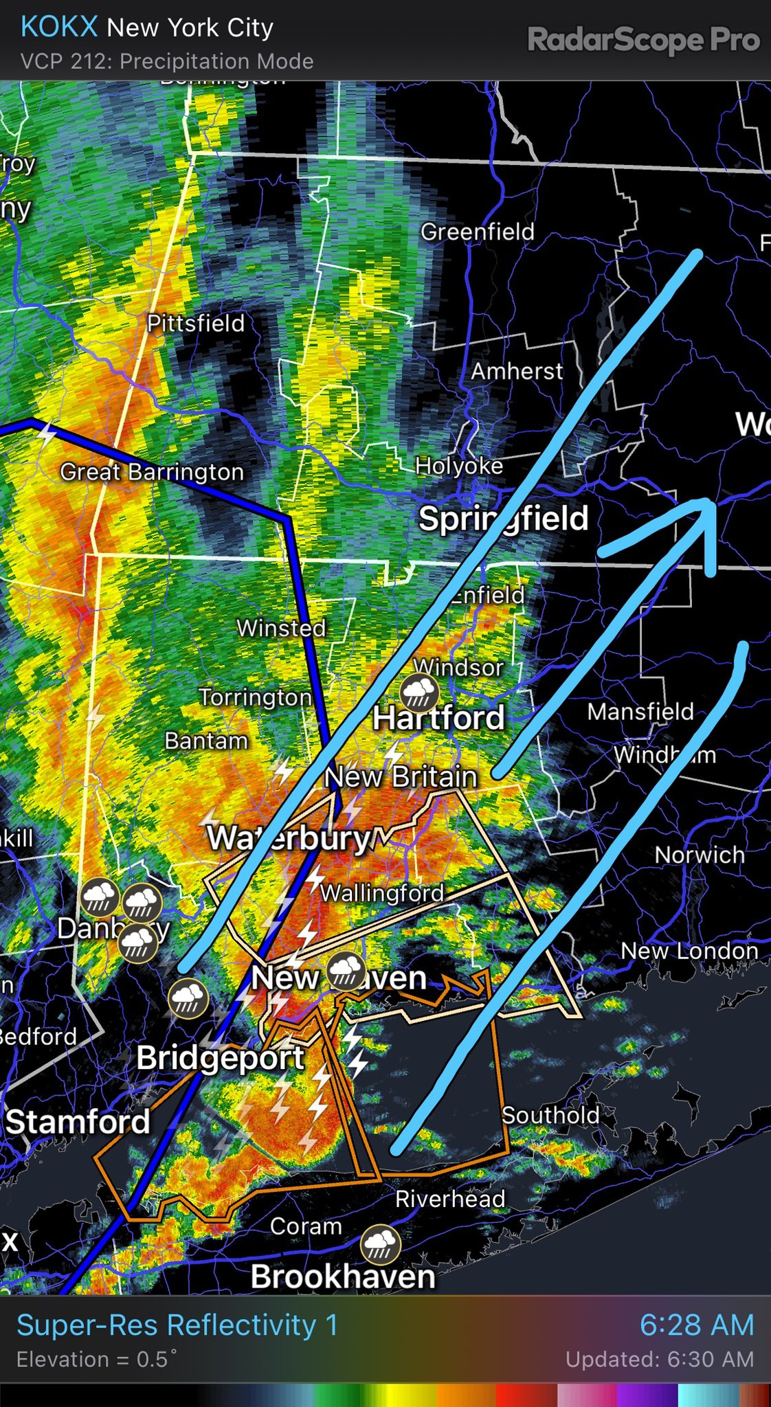
–Slow-going commute for some, especially along and east of the I-91 corridor
–Showers, downpours and thunderstorms will track quickly northeast through the region until about 11am
–Some torrential rainfall and localized strong wind gusts east of the CT River are expected
–Rotation is noted in some storms, can’t rule out a weak tornado in NE.CT or CMass, but unlikely
–Squall line also in the Berkshires with some wind and heavy rain, should be fairly short-lived
–Very humid, dewpoints in the 60s to low 70s, with some patchy fog observed already
–A mostly cloudy day with highs in the 70s to low 80s
–Isolated afternoon showers/storms could also turn strong to severe, but unlikely at this point
–Rain pushes east, and much drier air comes in behind a cold front tonight with dewpoint temps crashing, lows in the 50s
–A much nicer weekend ahead, with perhaps an isolated shower tomorrow, but likely mostly dry with partly sunny skies and westerly gusts to 20mph, highs in the mid 60s to low 70s, cooler!
–Warmer and more humid Sunday with highs mid 70s to low 80s under sunny skies
–Monday clouds up later in the day, humid, some showers possible at night, highs low to mid 80s
–Tuesday into the middle of next week looks cooler, drier and nice at the moment, but before we talk details let’s check a note from our local and delicious sponsor, #TandemBagelCo, with their newest location in the Stop & Shop Plaza on King Street in Northampton, MA.
~~~~~~~~~~~~~~~~~~~~~~
>>> A NOTE FROM OUR SPONSOR <<<
Dave Hayes The Weather Nut is Sponsored by Individual Community Members, Patrons & Tandem Bagel Company… No matter the weather, Tandem Bagel is always there for you at several valley locations to make your mornings brighter! With bagels baked fresh daily (including Gluten-Free options), house-whipped cream cheese, coffee, and tons of lunch options, Tandem is the perfect quick stop for lunch, breakfast, or a coffee and bagel to go. Find them in Easthampton, Northampton, Hadley, Florence, and West Springfield, or use their super-streamlined online ordering tool by visiting their website.
>>> MORNING DISCUSSION <<<
Good morning everybody, we have thunderstorms, showers and downpours moving through the region this morning associated with high humidity and a warm front.
The morning commute will be slow-going for some, as we have a squall line with torrential rain in the Berkshires pressing east, and storms developing in the Pioneer Valley with a supercell producing a strong to severe storm cluster in central and eastern CT heading into far southeast Hampshire County, eastern Hampden County and central MA and RI at 7am.
Strong gusty winds, frequent lightning, street flooding, and localized wind damage are possible in a few of these cells. Patchy fog is currently observed in some spots this early morning as well, but that should burn off.
This activity will clear out of here by very late morning toward the noon hour.
Then we will watch a cold front press east and produce a few more isolated showers and thunderstorms this afternoon before much drier and more comfortable air arrives tonight.
Highs will be in the 70s to low 80s and then lows will drop into the 50s with dewpoints hitting similar values.
This weekend looks pretty nice right now, especially Sunday!
Saturday will be a bit breezy behind the cold front with westerly gusts to 20mph at times, and partly sunny skies and highs in the mid 60s to low 70s with lows in the 50s with more clear skies.
Sunday is the pick of the weekend with highs in the mid 70s to low 80s under mostly sunny skies but humidity will be increasing with lows either side of 60º.
Monday looks very warm and humid with highs in the low to mid 80s, and some showers moving in with a wave rounding the westerly flank of an upper low center off to our northeast.
Highs again reach the low to mid 80s, but behind this wave, temps will crash into the 70s from Tuesday through much of next week with fair weather as far as I can tell right now, but I will update you as we get closer.
Give yourself extra time this morning for travel as visibility will be reduced in heavy rain.
Have a great day!
>>> BE KIND <<<
“Hello babies. Welcome to Earth. It’s hot in the summer and cold in the winter. It’s round and wet and crowded. On the outside, babies, you’ve got a hundred years here. There’s only one rule that I know of, babies: Goddamn it, you’ve got to be kind.”
–Kurt Vonnegut