
TABLE OF CONTENTS
* Daily Celestials (Sun/Moon Data)
* Sponsor Section
* Morning Discussion
* TIP: Scroll to your section, or read all
~~~~~~~~~~~~~~~~~~~~~~
YOUR DAILY CELESTIALS
~~~~~~~~~~~~~~~~~~~~~~
STAR:
–OUR STAR ROSE AT: 6:00am this morning
–OUR STAR WILL SET AT: 7:47pm this evening
–TOTAL DAYLIGHT TIME: 13 hours and 47 minutes
MOON:
–OUR MOON WILL RISE AT: 6:58pm this evening
–MOON RISE DIRECTION: Southeast
–OUR MOON WILL SET AT: 4:09am tomorrow morning
–MOON SET DIRECTION: West-Southwest
–MOON PHASE: Waxing Gibbous (92.7%)
~~~~~~~~~~~~~~~~~~~~~~
>>> A NOTE FROM OUR WEEKEND SPONSOR <<<
Dave Hayes The Weather Nut is Sponsored by Individual Community Members, Patrons, and Gerard, Ghazey & Bates, P.C. GGBPC is a Northampton-based law firm regarded as the voice of pragmatic and well-reasoned estate planning, elder law and tax guidance in Western Massachusetts. The firm specializes in estate planning law, and expertly handles other matters such as Elder Law, Tax Law, as well as Real Estate purchase, sales, and refinance transactions. Contact GGBPC today to see how they can help!
~~~~~~~~~~~~~~~~~~~~~~
YOUR MORNING DISCUSSION
~~~~~~~~~~~~~~~~~~~~~~
Good morning peoples of Earth, this is your Weather Nut of the West, and I bring future good tidings and well wishes for The Whooshening that will befall all of us by Tuesday night through the rest of the week.
Until then, I give you The Stinkening, as in this weather kinda stinks. In one specific way, it does so literally as we deal with the remnant wildfire smoke that was directed southward into our region, peaking yesterday.
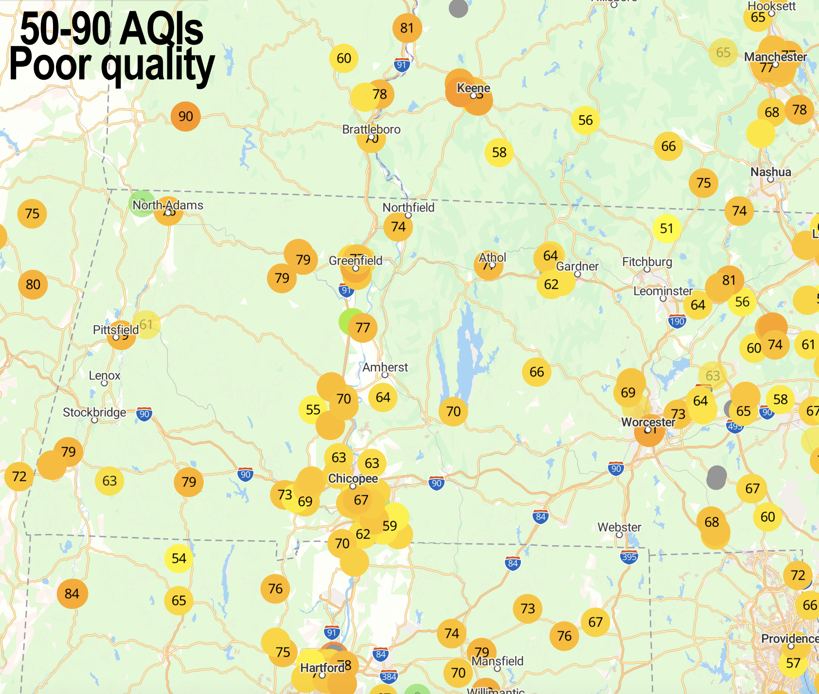
Air Quality Indices are in the 50-90 range this morning which is moderate to unhealthy. It will lower through today and tonight, and so improvements are expected, but kind of a tough morning for asthmatics and other respiratory-issue sufferers.
Some scattered showers are working northeast into the Berkshires and areas west of the I-91 corridor, along with northwest CT, and these should be mainly light to moderate and weaken with time.
Highs today will reach the mid 70s to low 80s under mostly cloudy skies with an occasional shower possible. It will be humid today, tonight, and through Sunday and Monday as well.
Lows tonight dip into the low to mid 60s with patchy fog possible (as we see this morning for a few areas).
Showers will increase in the pre-dawn hours of Sunday morning, and for now Sunday morning looks to be on the wetter side as a wave moves through the region.
A lull is possible by afternoon, but as more humid air moves into the region, periods of showers are still expected in the afternoon, before another wave works in at night into Monday morning with more rainy periods.
Highs Sunday reach the mid to upper 70s with lows in the low to mid 60s.
Monday is the wettest of this stretch as a cold front will be pushing into western PA and NY and start focusing increasing humidity with lift from the front and producing what looks like a pretty wet Monday, with thunderstorms and downpours possible as moisture levels increase ahead of the front.
Highs Monday will rise into the 70s with lows near 60º.
Our upper low associated with this cold front will need to pass east through the region on Tuesday, and upper low always bring some disorganized, loose clusters of showers, so as the front will be east of our region by Tuesday, we should still see some scattered showers into the mid to late afternoon with highs in the mid 60s to low 70s as dewpoints crash into the 40s and 50s.
Tuesday night clears out and super dry and chilly air works in with lows in the upper 40s to low 50s as skies clear.
A truly massive high pressure cell pushes east into our region, and much of the eastern U.S., which drying and cooling west and northwest flow mid to late week.
This will produce highs in the 60s and 70s and lows in the 40s and 50s with MUCH drier air working into the region.
A taste of Autumn is on the way!
Have a great day!
HAIKU OF THE DAY:
Summer’s spine has snapped
Humid smokey surges stink
Whooshenings approach
“Follow your bliss and the universe will open doors for you where there were only walls.”
― Joseph Campbell