
>>> YOUR DAILY CELESTIALS <<<
STAR:
–OUR STAR ROSE AT: 5:59am this morning
–OUR STAR WILL SET AT: 7:48pm this evening
–TOTAL DAYLIGHT TIME: 13 hours and 49 minutes
MOON:
–OUR MOON WILL SET AT: 8:43pm this evening
–MOON SET DIRECTION: West-Northwest
–OUR MOON WILL RISE AT 7:58am tomorrow morning
–MOON RISE DIRECTION: East
–MOON PHASE: Waxing Crescent (1.2%)
~~~~~~~~~~~~~~~~~~~~~~
>>> DAVE’S WEEKLY WEATHER NUTSHELL <<<
–Humid today, with increasing humidity tonight resulting ini dew points rising into the 70s by Friday
–Any patchy fog burns off, and we’re left with mostly cloudy skies today, with some sunny breaks by afternoon with weak high pressure in place, highs upper 70s to low 80s
–A few widely scattered showers will develop and drift northeast this afternoon
–Clouds thicken tonight, and showers will increase overnight, lows 60s
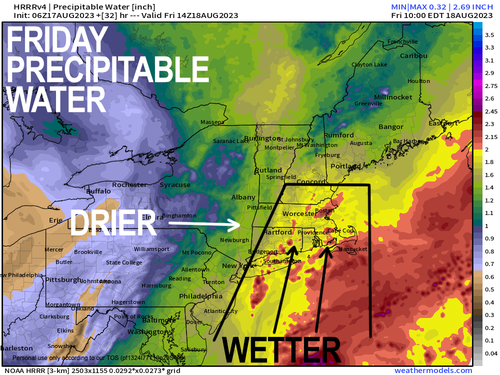
–Friday morning looks rainy, with downpours and thunderstorms as well… similar high temps to today, very humid
–Some storms may producer strong gusty winds, and isolated flash flooding is possible, with weak tornado potential well east of I-91 in Worcester County and NE.CT
–Showers and thunderstorms continue into the afternoon, and quit by around dinner time, and certainly before sunset
–Much drier air rushes into the region Friday night as temps plunge into the 50s, as well as dew points
–Way drier Saturday, with partly sunny skies, and a few isolated instability showers, highs 70-75º, lows in the 50s
–Sunday is sunny with highs 75-80º and dry
–Humidity increases Monday with highs in the low to mid 80s under mostly sunny skies
–Wind shifts from northwest to southwest Tuesday with increasing humidity and scattered showers possible by later Tuesday night to Wednesday morning, but before we talk details let’s check a note from our local and delicious sponsor, #TandemBagelCo, with their newest location in the Stop & Shop Plaza on King Street in Northampton, MA.
~~~~~~~~~~~~~~~~~~~~~~
>>> A NOTE FROM OUR SPONSOR <<<
Dave Hayes The Weather Nut is Sponsored by Individual Community Members, Patrons & Tandem Bagel Company… No matter the weather, Tandem Bagel is always there for you at several valley locations to make your mornings brighter! With bagels baked fresh daily (including Gluten-Free options), house-whipped cream cheese, coffee, and tons of lunch options, Tandem is the perfect quick stop for lunch, breakfast, or a coffee and bagel to go. Find them in Easthampton, Northampton, Hadley, Florence, and West Springfield, or use their super-streamlined online ordering tool by visiting their website.
>>> MORNING DISCUSSION <<<
Good morning everybody, we’ve got weak high pressure in place today, and as such it’s not going to really provide the level of sinking air and compression we need to dry out the cloud deck, though some sunny breaks are expected at times.
It should end up being a more-clouds-than-sun day within a humid air mass, and we should also see some widely scattered showers develop in spots during the afternoon with highs either side of 80º.
As a potent surface low near James Bay Canada and its upper level low pushes further east toward northern New England and southern Quebec, the cyclonic flow around that low (counterclockwise, if you’ll remember) will “pick up” a lollygagging frontal boundary near the south coast and return it northward as a warm front tonight into Friday.
This will cause humidity to increase overnight, along with thickening clouds, and an increase in the number of showers lifting north from the southern coastline.
Lows will only be in the 60s, and we could see some patchy fog as humidity increases.
By Friday morning, many of us should be seeing showers moving through, along with some downpours and thunderstorms.
By later morning into the afternoon, some storms may become severe as modest surface heating combines with deep moisture surge and strong wind shear aloft moving through the region.
Isolated areas of damaging wind gusts and/or flash-street flooding are possible, along with a weak tornado well east of the valley. That tornadic threat is more geared towards CMass, EMass, eastern CT and RI.
By late afternoon into the every early evening sometime is when the cold front should be clearing through the region, sweeping this muggy morass out to sea, with a mini-Whooshening setting up for Friday night as dewpoints dive from the low to mid 70s to the low to mid 50s by Saturday morning! Temps will hit those numbers, too.
The weekend looks nice overall, with Sunday being the sunny/dry pick, and Saturday featuring more partly sunny skies with a few isolated showers given much cooler air aloft moving overhead, which will create some afternoon instability during the peak heating of the day.
Highs are 70-75 Saturday, and 75-80º on Sunday with lows in the 50s.
The Monday to Wednesday timeframe looks mostly dry, but we should see a period of showers work through sometime between Monday night and Wednesday, but I will have to refine that timing as we get closer. The activity will be associated with a shortwave rounding the western flank of tomorrow’s upper low which will over Atlantic Canada by early next week.
Have a great day!
>>> BE KIND <<<
“Hello babies. Welcome to Earth. It’s hot in the summer and cold in the winter. It’s round and wet and crowded. On the outside, babies, you’ve got a hundred years here. There’s only one rule that I know of, babies: Goddamn it, you’ve got to be kind.”
–Kurt Vonnegut