
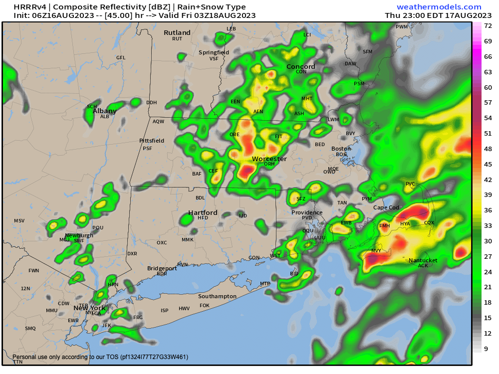
Thursday night showers/storms
>>> YOUR DAILY CELESTIALS <<<
STAR:
–OUR STAR ROSE AT: 5:58am this morning
–OUR STAR WILL SET AT: 7:49pm this evening
–TOTAL DAYLIGHT TIME: 13 hours and 51 minutes
MOON:
–OUR MOON WILL SET AT: 8:22pm this evening
–MOON SET DIRECTION: West-Northwest
–OUR MOON WILL RISE AT 6:56am tomorrow morning
–MOON RISE DIRECTION: East-Northeast
–MOON PHASE: NEW MOON (0.0%)
~~~~~~~~~~~~~~~~~~~~~~
>>> DAVE’S WEEKLY WEATHER NUTSHELL <<<
–A morning set of showers tracks northeast into the Pioneer Valley eastward in MA and CT
–A mixed sky day with clouds and some patchy fog or drizzle early, then with a few sunny breaks later, with a few more scattered showers
–Isolated showers possible after sunset, perhaps a thunderstorm
–Thursday should see more in the way of sunshine, call it partly sunny, but we’ll see some scattered showers during the day as well
–Thursday night sees a warm front push heavier rain showers or a couple of thunderstorms in on the nose of much muggier / moister air
–Friday is a potential severe weather day for some as very moist air along with strong wind shear and potential growing instability with surface heating may combine to produce thunderstorms with heavy rain and strong to damaging wind gusts in a few spots
–We’re basically 75-80º over the next three days for highs with lows in the 50s to 60s
–Any showers die out Friday night and we cool down and lower the humidity, leading to a gorgeous weekend which could extend through Tuesday night, but before we talk details let’s check a note from our local and delicious sponsor, #TandemBagelCo, with their newest location in the Stop & Shop Plaza on King Street in Northampton, MA.
~~~~~~~~~~~~~~~~~~~~~~
>>> A NOTE FROM OUR SPONSOR <<<
Dave Hayes The Weather Nut is Sponsored by Individual Community Members, Patrons & Tandem Bagel Company… No matter the weather, Tandem Bagel is always there for you at several valley locations to make your mornings brighter! With bagels baked fresh daily (including Gluten-Free options), house-whipped cream cheese, coffee, and tons of lunch options, Tandem is the perfect quick stop for lunch, breakfast, or a coffee and bagel to go. Find them in Easthampton, Northampton, Hadley, Florence, and West Springfield, or use their super-streamlined online ordering tool by visiting their website.
>>> MORNING DISCUSSION <<<
Good morning everybody, I’ll start by saying that all upcoming weekend plans are a go!
Much lower humidity, sunny skies, highs in the 70s to low 80s, with lows in the 50s and lower humidity will allow for all outdoor activities to go off without a problem.
Before that, however, we have to get through three days that likely feature more clouds than sun, with occasional scattered showers today, tonight and tomorrow, prior to a warm-cold front combo for Thursday night into Friday that could bring some strong to severe thunderstorms into our region.
High temps during the next three days will be in the 75-80º range, with highs on Saturday only reaching the low to mid 70s (which this writer is THRILLED about), and then Sunday should rebound into the upper 70s to mid 80s, with lows during tonight/tomorrow in the low to mid 60s, and only in the 50s over the weekend.
For today, we have a mid-level system over NY state and its proximity will help spark some occasional isolated to scattered showers, generally tracking northeast this morning, and more easterly this afternoon/evening, with dry periods in between, as well as a few sunny breaks. A couple of showers tonight for a few folks, otherwise just have to watch for patchy fog late.
On Thursday, we’ll see more in the way of some sunny breaks mixed in with clouds, and again will see a few scattered showers, but not a washout during the day.
At night, however, a warm front will lift northward into the region, and showers and thunderstorms will likely break out before midnight and produce heavy rain for some, though the severe weather threat seems to be more relegated to the cold frontal passage Friday afternoon.
At that time (on Friday) much stronger wind shear than we’ve seen in a while could advect into the region ahead of the cold front, and this means we have to be on guard for a potential severe weather impact related to strong straight-line wind gusts and possible wind damage, with a few outages.
I don’t have a specific timeframe in the afternoon/early evening, but will update as we get closer, in terms of when these storms are most likely to come through.
Showers end during the evening, and then much drier and cooler air works into the region with lows in the 50s, which will proceed a GORGEOUS weekend with mostly sunny skies and light winds.
There is a chance for another reinforcing cold front to move through sometime Monday night into early Tuesday, but it’s possible we maintain cooler, drier air with fair weather through into the middle of next week, but I will ply you with weather details as they emerge into more clarity over the coming days.
Have a great day!
>>> BE KIND <<<
“Hello babies. Welcome to Earth. It’s hot in the summer and cold in the winter. It’s round and wet and crowded. On the outside, babies, you’ve got a hundred years here. There’s only one rule that I know of, babies: Goddamn it, you’ve got to be kind.”
–Kurt Vonnegut