
Good morning folks, another cool and crisp morning has visited us with temps in the 50s, with a few upper 40s north of the Rt. 2 corridor.
To summarize, we’ve got one more partly to mostly sunny day with some northeasterly breezes setting up before clouds build overnight with a few showers tomorrow, followed by increasing sunshine late week into the weekend with increasing temps and increasing humidity by early next week with a few thunderstorms possible, but before we dive into all of the weather details below, let’s check a note from our local and delicious sponsor, #TandemBagelCo, with their newest location in West Springfield, MA.
——————–
A NOTE FROM OUR SPONSOR:
DHTWN Is Sponsored by Members, Patrons & Tandem Bagel Company: No matter the weather, Tandem Bagel is always there for you at several valley locations to make your mornings brighter! With bagels baked fresh daily, house-whipped cream cheese, coffee, and tons of lunch options, Tandem is the perfect quick stop for lunch, breakfast, or a coffee and bagel to go. Find them in Easthampton, Northampton, Hadley, Florence (and now West Springfield!), or use their super-streamlined online ordering tool by visiting their website: https://www.tandembagelco.com
——————————————-
***DHTWN DAILY WEATHER REPORT***
——————————————-
NWS ALERTS
–There is an elevated risk for Fire Spread today given northeasterly gusts over 20mph at times with very dry ground fuels present due to the ongoing drought. Operate fires responsibly, and if you smoke butts don’t be a dope, and CAREFULLY extinguish your cigarettes.
DHTWN REMINDER
–The odds of being a human is 1 in 400 trillion… make it count, even in a small way (see Kurt Vonnegut quote at end of post)
DAILY CELESTIAL (STAR):
–OUR STAR ROSE AT: 5:59am this morning
–OUR STAR WILL SET AT: 7:49pm this evening
–TOTAL DAYLIGHT TIME: 13 hours and 50 minutes
DAILY CELESTIAL (MOON):
–OUR MOON WILL RISE AT: 10:26pm tonight
–OUR MOON WILL SET AT: 12:15pm tomorrow afternoon
–MOON RISE DIRECTION: East-Northeast
–MOON SET DIRECTION: West-Northwest
–MOON PHASE: Waning Gibbous 76.7%
———————-
DAILY TERRESTRIAL (ZoneCast)
ZONE 1 (Northern Region)
Southern VT, Southwest NH, N. Taconics NY
–High Temps: Mid 70s to Low 80s
–Low Temps: Mid to Upper 50s
–Humidity: Comfortable with dewpoints in the 40s and 50s, rising toward 60º in CMass tonight
–Wind: East and northeast winds will gust 10-20mph later today
–Skies: Partly to Mostly Sunny
–Precipitation: None expected
ZONE 2 (Central Region)
WMass, N. CMass, N. Litchfield County, C./S. Taconics NY
–High Temps: Upper 70s to Low 80s
–Low Temps: Mid 50s to Low 60s
–Humidity: Comfortable with dewpoints in the 40s and 50s, rising toward 60º in CMass tonight
–Wind: East and northeast winds will gust 10-20mph later today
–Skies: Partly to Mostly Sunny
–Precipitation: None expected
ZONE 3 (Southern Region)
S. CMass, S. Litchfield County, NC.CT, & NE.CT
–High Temps: Upper 70s to Low 80s
–Low Temps: Upper 50s to Low 60s
–Humidity: Comfortable with dewpoints in the 40s and 50s, rising toward 60º in CMass tonight
–Wind: East and northeast winds will gust 10-20mph later today
–Skies: Partly to Mostly Sunny
–Precipitation: None expected
———————-
WEATHER REPORT
Good morning everybody, do you ever wake up with a vehicle called “TheBulletizationMobile(TM)” driving up and down your spinal column and all around your brain, beeping its horn incessantly, demanding that you employ the utilization of double–dashes to list out the salient points of your daily morning weather report for the greater WMass region?
No? Is that just me? Hmmmm, perhaps I should go see my PCP about this emerging issue, but in the meantime, I think I better comply with TBM’s morning mandate, because who knows what it’ll do next!
SUMMAH-RY
–We have a lovely partly to mostly sunny day ahead as exiting high pressure to the east provides enough surface influence to keep us dry with highs mostly in the upper 70s to low 80s
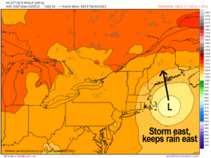
–As a surface low tracks northeast from off of the coast of NC to south of Nantucket, we’ll start developing an onshore wind later today and tomorrow
–Easterly to northeasterly gusts of 10-20mph or so are possible this afternoon and overnight
–Some fair weather cumulus will develop today as well thanks to a colder pool of air aloft as a mid level low tracks overhead
–For tonight, clouds will fill in and it should become mostly cloudy as our mostly-missing storm comes closer to New England, with lows in the mid 50s to low 60s
–For Wednesday, a mostly cloudy day is expected, though some sunny breaks could be scattered about further west near the Berkshires and northwest CT
–Highs will only reach the low to mid 70s, and some scattered showers will be possible
–Best chance of getting up to a quarter or maybe third of an inch of rain is eastern parts of Cheshire County NH, eastern and northern CMass, and NE.CT
–Otherwise, many of us will see little to no rainfall with just a few showers, which is very frustrating, because we need the rain, and it’s hard to develop a coastal storm like this in August… just doesn’t happen a lot
–Lows Wednesday night with a few showers will dip into the mid to upper 50s
–Any lingering showers well east of the I-91 corridor depart Thursday morning, and we’ll be left with northwesterly flow for a day as our coastal low will have tracked east of Nantucket, north into the Gulf of Maine, and will be pulling northeast and away from New England
–Highs will reach the mid 70s to low 80s on Thursday under mostly sunny skies with lows in the 50s
–On Friday, we warm up with reasonable humidity and highs in the mid to upper 80s under mostly sunny skies and lows in the upper 50s to low 60s
–The weekend will be fairly hot as high pressure off of the Carolina coastline flexes/waxes, helping to produce southwest flow and highs into the mid 80s to low 90s and lows in the 60s with fair weather expected
–By early next week, humidity surges and it will become quite muggy, but temps should tamp down into the 80s for highs, and we’ll be watching a trough and frontal system in the Great Lakes start to move toward the region
–It may get through our region by Tuesday, but may linger as well, with scattered showers and thunderstorms expected to take advantage of the increase in humidity, so stay tuned for updates on the start of our next work week
That does it for now, my friends, I hope you have a great day!
Remember that you can also follow me on Twitter.
AND REMEMBER…
“Hello babies. Welcome to Earth. It’s hot in the summer and cold in the winter. It’s round and wet and crowded. On the outside, babies, you’ve got a hundred years here. There’s only one rule that I know of, babies: Goddamn it, you’ve got to be kind.”
–Kurt Vonnegut