
TABLE OF CONTENTS
* Daily Celestials (Sun/Moon Data)
* Sponsor Note
* Join My Newsletter
(& get my Top12WMassStorms ebook!)
* Morning Discussion
* TIP: Scroll below for sections, or read all
~~~~~~~~~~~~~~~~~~~~~~
YOUR DAILY CELESTIALS
~~~~~~~~~~~~~~~~~~~~~~
STAR:
–OUR STAR ROSE AT: 5:58am this morning
–OUR STAR WILL SET AT: 7:50pm this evening
–TOTAL DAYLIGHT TIME: 13 hours and 52 minutes
MOON:
–OUR MOON WILL RISE AT: 5:18pm this afternoon
–MOON RISE DIRECTION: Southeast
–OUR MOON WILL SET AT: 1:42am tomorrow morning
–MOON SET DIRECTION: Southwest
–MOON PHASE: Waxing Gibbous (76.9%)
~~~~~~~~~~~~~~~~~~~~~~
A NOTE FROM OUR SPONSOR
~~~~~~~~~~~~~~~~~~~~~~
Dave Hayes The Weather Nut is Sponsored by Individual Community Members, Patrons, and Tandem Bagel Company… No matter the weather, Tandem Bagel is always there for you at several valley locations to make your mornings brighter! With *New Pizza Bagels(!)*, along with bagels baked fresh daily (including Gluten-Free options), house-whipped cream cheese, coffee, and tons of lunch options, Tandem is the perfect quick stop for lunch, breakfast, or a coffee and bagel to go.
You can either 1) visit them in Easthampton, Northampton, Hadley, Florence, and/or West Springfield, 2) hire them to cater your next event, or 3) use their super-streamlined online ordering tool by visiting their website and clicking the “Catering” or “Order Online” links.
~~~~~~~~~~~~~~~~~~~~~~
DAVE’S WEEKLY NEWSLETTER (Top 12 WMass Storms)
DAVE’S MOBILE APP (Late 2024 Release)
~~~~~~~~~~~~~~~~~~~~~~
YOUR MORNING DISCUSSION
~~~~~~~~~~~~~~~~~~~~~~
Good morning everybody, we’re starting off with patchy fog in a few spots and temps in the 50s to low 60s with fairly low dewpoints as well.
Temps will come up as our August sun angle still has some oomph to it, and highs will rise into the low to mid 80s under partly sunny skies, which will become increasingly hazy this afternoon and evening.
This is because an upper level trough has swung down out of southeast Canada, and is directing a stronger plume of wildfire smoke through our region this afternoon and overnight, so air quality may be compromised as well.
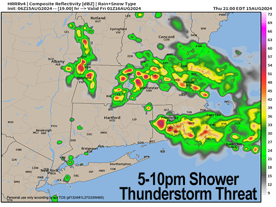
In addition, said upper trough will send some energy our way to combine with warm and humid surface conditions, a bit of wind shear, and a bit of instability so I expect isolated to scattered showers and thunderstorms to develop later this afternoon and evening, especially along and east of the I-91 corridor in southwest NH, WMass, CMass and northeast CT (though a shower or storm is possible west of I-91, too).
Any storms could become strong to severe with larger hail or strong gusty winds.
This activity will die down tonight as the upper low gets a kick in its rear by incoming high pressure from our west.
Lows tonight will sit down to either side of 60º, and our warmest day of the next 5-7 will develop on Friday under mostly sunny skies, with highs temps well into the 80s as humidity creeps up as well. Clouds will increase late and lows will be milder, resting in the low to mid 60s.
Saturday is a transition day back into inclement weather potential as an upper level trough out of the Great Lakes will swing east toward New England.
I expect mostly cloudy skies at this time with highs in the upper 70s to low 80s, though we may start off partly sunny with potential for a mostly dry day.
Still, by late afternoon or the evening into the early night showers should start to filter into the region, with lows in the low to mid 60s.
It is really the Sunday through Monday night period where the greatest chance for periods of scattered showers and thunderstorms will be possible as a cold front slowly works east toward New England, likely passing through our region by Monday night or early Tuesday morning.
Humidity will be up in the 65-70º range Sunday and Monday, with highs in the 70s and lows in the 60s, so it will be quite muggy.
Monday is likely to be the wettest day of the upcoming stretch, and the showers and storms that form along the cold front could provide a solid soaking for the region.
Tuesday is our day of transition back into drier conditions, with early morning showers possible, and lower dewpoint air arriving by Tuesday night and into Wednesday, which will feel wonderful.
Have a great day!
“Follow your bliss and the universe will open doors for you where there were only walls.”
― Joseph Campbell